
Apr 28, 2026
How to Integrate Water Management and Climate Resilience Strategies for Municipalities & Government Agencies
Sustainability Strategy
In This Article
Practical strategies for municipalities to align water management with climate resilience using governance, green‑grey infrastructure, data, and community engagement.
How to Integrate Water Management and Climate Resilience Strategies for Municipalities & Government Agencies
Municipalities face increasing challenges from climate change, aging infrastructure, and urban growth, making it critical to manage water systems more effectively. This article provides actionable strategies to integrate water management and climate resilience, focusing on breaking down departmental silos, using data-driven planning, and combining green and grey infrastructure. Key takeaways include:
Governance Coordination: Form cross-departmental teams to streamline efforts and secure funding.
Risk Assessment: Use tools like the EPA’s CREAT to map vulnerabilities and prioritize investments.
Infrastructure Upgrades: Incorporate floodplain reconnection, rain gardens, and permeable pavements to mitigate risks.
Community Engagement: Involve residents in planning to address local concerns and improve funding opportunities.
Technology and Data: Leverage predictive models and real-time monitoring to guide long-term planning.
The City Water Resilience Approach
Creating Governance Frameworks for Integrated Water Management
Managing water effectively means breaking down silos between departments. Water utilities, stormwater managers, wastewater providers, and planning departments all need to work together to avoid duplicated efforts and funding shortfalls. Without such coordination, municipalities risk missing out on funding opportunities and leaving gaps in their climate resilience strategies.
Coordinating Across Departments
Regional challenges call for regional solutions. Take the example of a coastal county resilience authority that formed a 15-member board, bringing together municipal representatives and independent experts [5]. Within three years, this collaborative structure secured $340 million in infrastructure funding through bonds and federal grants [5]. Interlocal agreements empowered the central authority to oversee grants and implement projects across municipal boundaries, all while preserving local governments' control over building codes and land-use policies.
"Regional problems need regional governance. Municipal-level resilience planning in a shared watershed is inherently incomplete." [5]
Securing stable funding is another critical step. The same coastal authority introduced a resilience fee tied to impervious surface area and property value, generating $14 million annually. This reliable revenue stream supported bond financing and met federal match requirements [5]. With this financial foundation, the authority was able to fund multi-year infrastructure projects and meet federal funding criteria.
Protecting Vulnerable Populations and Critical Infrastructure
Equity must be woven into governance from the outset. For instance, resilience fees can include means-tested exemptions to prevent undue financial burdens on low-income property owners. Similarly, project prioritization should factor in impacts on disadvantaged communities alongside traditional benefit-cost analyses.
"Equity must be structural, not aspirational. Building equity into the governance structure... produced demonstrably more equitable outcomes than voluntary equity commitments." [5]
Monitoring critical infrastructure is equally essential. This involves mapping water distribution, treatment, and stormwater systems to assess their age, material integrity, and vulnerability to risks like subsidence and sea-level rise [7]. Departments must also collaborate to create unified building code enhancements, such as consistent freeboard requirements and stormwater retention standards, ensuring uniformity across jurisdictions [5].
Integrated governance not only secures funding and equitable outcomes but also strengthens data-driven decision-making, laying the groundwork for effective climate adaptation.
Setting Up Long-Term Decision-Making Protocols
Long-term planning should incorporate risk-informed protocols that use climate projections extending to 2100. Developing a prioritized project pipeline - ranked by benefit-cost ratios, equity considerations, and environmental co-benefits - based on multi-jurisdictional vulnerability assessments provides a clear roadmap [5]. Regional monitoring networks, like saltwater intrusion wells, can deliver early warnings, triggering pre-planned management actions across departments [5].
Rather than creating standalone documents, integrate water management and drought preparedness into existing comprehensive, strategic, and land-use plans [4][6]. This ensures that infrastructure investments, zoning policies, and emergency plans align with shared climate data and resilience goals. Additionally, federal and state funding increasingly favors regional, multi-jurisdictional proposals, highlighting the need for coordinated governance frameworks.
These measures not only prepare municipalities for future climate and hydrological risks but also position them to secure funding and implement effective, long-term solutions. Coordination, equity, and data-driven planning are the cornerstones of resilient water management.
Assessing Climate and Hydrological Risks
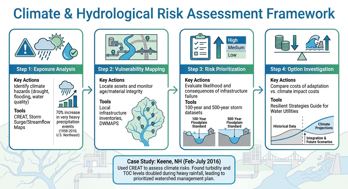
4-Step Climate Risk Assessment Framework for Municipal Water Management
To address climate and hydrological challenges effectively, municipalities should integrate historical records with climate projections. This combined analysis helps identify vulnerabilities in infrastructure, water quality, and supply reliability. By laying this groundwork, communities can make informed decisions about investments and adaptation strategies. The sections below delve into how this information supports detailed mapping and infrastructure risk assessments.
Mapping Watershed-Level Vulnerabilities
A comprehensive risk assessment starts at the watershed level rather than focusing solely on individual assets. Tools like the EPA’s Climate Resilience Evaluation and Awareness Tool (CREAT) allow water managers to input localized data and analyze risks to critical infrastructure such as reservoirs and well-fields [9][10]. For instance, between February and July 2016, officials in Keene, New Hampshire, conducted a climate risk assessment using CREAT. They combined pre-packaged climate data with local weather station statistics from a city dam, incorporating 100-year and 500-year storm datasets [9].
Effective mapping involves layering various types of data. Pair historical storm data with future projections of precipitation, temperature, and sea-level rise [9][7]. Also, account for changes in water quality - Keene’s assessment revealed that turbidity and total organic carbon (TOC) levels doubled during heavy rainfall, increasing treatment costs. As a result, the city prioritized developing a watershed management plan and investigating alternative water treatment methods to reduce waste and chemical usage [9].
For areas prone to wildfires, rising fire risks should be factored into dam operations and emergency planning [9][7]. Collaborative efforts among local water utilities, wastewater providers, and regional water managers are essential for a coordinated watershed-wide assessment [7]. This detailed mapping approach helps identify where infrastructure investments can yield the most resilience.
Finding Infrastructure Weak Points
Identifying vulnerabilities in infrastructure requires more than an inventory - it demands an evaluation of failure likelihood for each asset. By analyzing the age, condition, and location of infrastructure, municipalities can pinpoint risks such as subsidence or flooding [9][7]. Consequence analysis can then prioritize these risks by assessing both the likelihood of failure and its potential impact on critical systems like drainage structures and lift stations [9].
To enhance resilience, consider redesigning key assets using 500-year floodplain data instead of the standard 100-year benchmarks [9]. For known weak points, practical mitigation measures can make a significant difference. Examples include bolting down chemical tanks, elevating electrical equipment, and installing barriers around essential assets [11]. These cost-effective solutions can help prevent major failures during extreme weather events. Insights from this analysis also feed into advanced predictive models, enabling better preparation for future risks.
Combining Historical Data with Climate Projections
Accurate risk assessments depend on merging local and global datasets. Regional models can be enhanced by incorporating localized data, such as extreme weather records from infrastructure-specific weather stations [9]. Instead of relying solely on annual averages, use monthly precipitation data and statistics from extreme weather scenarios to model future conditions more effectively [9].
In the U.S. Northeast, precipitation during "very heavy precipitation events" increased by over 70% between 1958 and 2010 [9]. This trend highlights the inadequacy of historical averages for planning purposes. Municipalities should track how increased rainfall affects water quality indicators like turbidity and TOC to develop predictive models for future treatment needs [9]. This integrated approach enables cost-benefit analyses of potential climate impacts versus the costs of specific adaptation measures [9]. Such comprehensive data integration is crucial for informed decision-making in municipal water management.
Assessment Step | Key Actions | Tools/Data Sources |
|---|---|---|
Exposure Analysis | Identify climate hazards (drought, flooding, water quality) | |
Vulnerability Mapping | Locate assets and monitor age/material integrity | |
Risk Prioritization | Evaluate likelihood and consequences of infrastructure failure | 100-year and 500-year storm datasets [9] |
Option Investigation | Compare costs of adaptation vs. climate impact costs |
Using Ecosystem-Based and Infrastructure-Based Solutions
Blending natural processes with engineered systems creates a balanced approach to municipal water management. These hybrid "green-grey" strategies leverage nature-based solutions to handle fluctuating water loads while relying on traditional infrastructure for peak demands and critical safety functions [12]. Here’s how combining these methods can enhance water management resilience.
Combining Green and Grey Infrastructure
Pairing natural and engineered systems can lead to tangible benefits. Green infrastructure - such as bioswales and rain gardens - absorbs and manages initial rainfall, reducing the need for costly sewer upgrades [12]. A case in point is Pokhara City, Nepal, where planners tackled monsoonal flooding in the Barahi Chowk region by incorporating rain gardens across 3% of impervious areas and permeable pavements over 5%. Using the Storm Water Management Model (SWMM), they found rain gardens reduced peak runoff by 21.5%, while permeable pavements achieved a 26% reduction [1].
This approach works because natural systems are more adaptable to seasonal and climate variations than rigid structures. While grey infrastructure remains essential for handling extreme weather and safeguarding critical facilities, integrating green elements eases the strain on these systems and can even extend their lifespan. Beyond physical integration, restoring natural ecosystems further strengthens climate resilience.
Restoring Ecosystems for Climate Adaptation
Reconnecting rivers to their floodplains offers dual benefits: natural water storage and improved biodiversity. The Cosumnes River in California exemplifies this through levee removal and setback projects. By restoring the river's connection to its historical floodplain, researchers observed that juvenile native fish on the floodplain grew faster than those in the main channel, thanks to increased primary productivity [13].
Managed floodplains also provide robust protection against extreme flooding. The Yolo Bypass in California, a 41-mile-long and 3-mile-wide floodplain, shields Sacramento by channeling up to 14,000 cubic meters per second of flow - four times the capacity of the Sacramento River’s main channel [13]. Designed to flood two out of every three years, the bypass also supports a 25-square-mile wildlife area, offering critical habitats for migratory birds and salmon. With only 5% of historical riparian habitat remaining in California's Central Valley due to traditional flood control, restoration efforts like these are crucial [13].
"Conventional flood control has emphasized structural measures such as levees, reservoirs, and engineered channels - measures that typically simplify river channels and cut them off from their floodplain, both with adverse environmental consequences."
Anna Serra-Llobet et al. [13]
Designing Infiltration-Based Systems
Infiltration systems, grounded in thorough risk assessments, address immediate flooding concerns while supporting long-term groundwater recharge. Low Impact Development (LID) techniques - such as permeable pavements and bioswales - capture, infiltrate, and slow stormwater before it overwhelms urban drainage networks [1]. These systems are most effective when paired with traditional drainage to handle short, intense rainfall events that exceed their capacity.
Floodplain reconnection also facilitates managed aquifer recharge (MAR), where surface water seeps into aquifers during floods [1][13]. This process bolsters long-term water supply without relying on energy-intensive pumping or treatment. To maximize effectiveness, municipalities should prioritize restoring hydrologic connectivity by modifying levees, which is essential for ecological health [13]. Incorporating real-time monitoring and predictive models ensures these systems remain adaptive to changing conditions.
Using Data and Technology for Monitoring and Early Warning
Data and technology play a crucial role in developing strategies that integrate water management with climate resilience. Tools like real-time monitoring systems and predictive models are transforming how municipalities respond to water-related challenges. By combining short-term forecasts with long-term climate projections, agencies can make informed decisions that address immediate needs while planning for future infrastructure investments.
Setting Up Early Warning Systems
Early warning systems use a combination of sensors and climate forecasts to enable timely responses to potential water crises. For instance, municipalities can place stream gauges and sensors on vulnerable roadways to monitor water levels. When these levels exceed safe thresholds, automatic alerts are sent to emergency teams, ensuring a swift response [18][19]. In drought-prone areas, tools like NOAA's Climate Prediction Center track the El Niño Southern Oscillation (ENSO), helping water managers predict seasonal wet or dry conditions. This enables better planning, such as adjusting groundwater extractions [14].
A practical example comes from Tampa Bay Water, which serves over 2.4 million residents in Florida. Starting in 2015, the utility incorporated ENSO outlooks to predict short-term water availability and used downscaled Global Climate Models (GCM) to estimate future demand increases - from 240 million gallons per day (mgd) to 275 mgd by 2035. These insights guided the construction of a $158-million desalination plant and a 15-billion-gallon reservoir, which provided critical backup supplies during droughts in April 2017 and March 2020 [14]. This integration of early warnings into predictive systems highlights how proactive planning can support long-term climate adaptation.
Using Predictive Modeling for Climate Adaptation
Predictive models take early warning systems a step further by simulating various future climate scenarios to refine long-term planning. By downscaling Global Climate Models to regional scales, utilities can achieve more precise projections, especially in areas with unique topographies or microclimates [14]. For example, the U.S. EPA's Climate Resilience Evaluation and Assessment Tool (CREAT) enables utilities to evaluate risks like storm surges and streamflow changes under different climate scenarios. This tool has been instrumental in helping utilities like Miami-Dade Water and Sewer Department and Seattle Public Utilities develop targeted strategies for challenges such as sea-level rise and reduced snowpack [17].
Tool Name | Primary Function | Climate Hazard Addressed |
|---|---|---|
CREAT | Risk assessment and asset evaluation | General climate threats |
Storm surge inundation mapping | Hurricanes/Flooding | |
Streamflow Maps | Low, average, and high flow projections | Drought/Water scarcity |
ENSO Outlooks | Seasonal climate forecasting | Drought/Excessive rainfall |
Creating Feedback Loops for Adaptive Management
To maintain resilient water systems, continuous monitoring and improvement are essential. Monitoring systems are most effective when their data informs actionable changes. For instance, leak detection sensors installed along pipelines and storage facilities can provide instant alerts, allowing for quick repairs and minimizing water loss [16][3]. Municipal dashboards that track water usage across operations help staff identify conservation opportunities and understand consumption patterns [15][3].
Additionally, maintaining an up-to-date inventory of infrastructure, including the age and material condition of pipes, is critical. Aging infrastructure is more susceptible to damage under climate stress, such as subsidence or extreme weather [14][3]. By combining historical data with updated climate projections, agencies can refine drought thresholds and ensure their plans remain relevant and effective [3].
Involving Communities in Water Management and Climate Resilience
Building on earlier discussions about coordinated governance and data-driven risk assessments, engaging communities emerges as a crucial next step. Effective water management strategies thrive on active participation from the people they aim to serve. Municipalities that overlook genuine community involvement often end up with technically sound plans that fail to address local concerns and remain unused [2]. On the other hand, prioritizing community voices leads to stronger funding opportunities, increased public trust, and projects that align with actual needs.
Supporting Water-Based Livelihoods
Connecting water resilience efforts to local economic opportunities creates a win-win scenario: better infrastructure and empowered communities. Municipalities can develop jobs in areas like green infrastructure, ecosystem restoration, and weatherization, which not only improve climate adaptation but also provide stable employment [20]. Hiring local residents - whether as block captains, community health workers, or faith leaders - ensures that planning efforts reach those most affected. These residents bring invaluable insights into vulnerabilities that technical models might miss. By integrating local economic opportunities into resilience projects, municipalities promote inclusive and collaborative decision-making.
Building Collaborative Decision-Making
A coastal city in the Mid-Atlantic region, home to 28,000 residents, offers a compelling example of structured community engagement. In February 2026, the city launched a three-tier process: a community-wide survey with a 22% response rate, six neighborhood workshops with childcare and Spanish translation, and an 18-member advisory committee representing diverse stakeholders, including the NAACP and local business owners. Through this process, residents identified a critical flooding risk tied to a legacy Superfund-adjacent site - an issue that technical models had overlooked. The city’s efforts secured $14.7 million in federal and state grants within 18 months and placed a FEMA BRIC application in the top 15% nationally [2].
"Lead with data, but center the community. The technical vulnerability assessment was essential for grant competitiveness... but the community engagement process determined which projects actually moved forward." - Council Fire [2]
Removing barriers to participation is essential for meaningful engagement. Hosting meetings in accessible locations like community centers, schools, or churches - rather than government buildings - can make a big difference. Offering childcare, food, and translation services ensures broader participation [20]. Beyond traditional public hearings, participatory methods such as community mapping, storytelling circles, and photovoice projects allow residents to share their perspectives on local hazards in their own words [20]. Combining these insights with technical assessments results in more effective and locally relevant strategies.
Ensuring Fair Access to Water Resources
Focusing on frontline communities helps prevent the reinforcement of existing inequities. Vulnerability mapping can pinpoint neighborhoods at the intersection of high hazard exposure, aging infrastructure, and limited financial resources. Using these maps, municipalities can prioritize community-driven concerns when allocating resources [20]. Pairing infrastructure upgrades with affordable housing protections is also critical to avoid "climate gentrification", where resilience improvements inadvertently displace the very residents they aim to protect [20].
The financial benefits of equitable planning are undeniable. FEMA reports that every $1 invested in hazard mitigation saves $6 in disaster recovery costs [20][21]. Federal grants for resilience and water infrastructure often cover 75% to 90% of project costs, making community-centered approaches financially practical [20]. Municipalities that focus on equitable access not only improve infrastructure but also build stronger, more adaptable communities prepared for future climate challenges.
Conclusion
Summary of Actionable Strategies
Bringing together water management and climate resilience demands breaking down institutional barriers between water supply and flood control. Successful municipalities create unified systems where technical data informs engineering choices, and community input shapes which projects gain traction and support. The strategies in this guide - from forming cross-departmental governance teams to using nature-based solutions like rain gardens and living shorelines - work collectively to tackle challenges like tidal flooding, intense rainfall, and lingering pollution. Aligning resilience plans with federal funding requirements, such as benefit-cost analyses and equity scoring, ensures municipalities are prepared for grants and long-term achievements. These strategies lay the groundwork for impactful, measurable results.
Long-Term Benefits of Integrated Approaches
Case studies show that integrated methods not only reduce costs but also open doors to substantial federal and state funding. Beyond financial advantages, these approaches bring added benefits like better water quality, restored habitats, and relief from urban heat. For instance, incorporating green infrastructure across 25% of urban spaces can cut peak runoff by the same percentage, significantly improving flood control while enhancing neighborhood livability [1].
Next Steps for Public Sector Leaders
To build on these benefits, public sector leaders should take immediate action. Start by organizing planning sessions with local water utilities, wastewater managers, and regional stakeholders to align strategies. Conduct operational audits focused on leak detection and repair programs, which are often more cost-efficient than reactive drought measures. Revise building codes to mandate higher freeboard levels - such as three feet above base flood elevation - and limit new critical infrastructure in 500-year floodplains [2]. Establish resilience hubs in accessible community spaces equipped with backup power and cooling systems to protect vulnerable populations during extreme weather. Shift from relying on static historical data to adopting dynamic regional water models to ensure infrastructure investments are future-ready. Taking these steps within an integrated water management framework will help municipalities achieve resilient and sustainable outcomes.
FAQs
Where do we start if departments won’t collaborate?
If working together seems challenging, consider setting up a forum that brings together local water utilities, wastewater providers, and water managers. This allows for joint assessments and planning sessions, encouraging a shared understanding among stakeholders. Such collaboration can lead to the creation of integrated water management plans. Another helpful step is compiling regional inventories of infrastructure and assessing the effects of climate change. These efforts can reveal shared priorities, strengthen trust, and lay the groundwork for continued cooperation.
What data do we need to run a climate risk assessment?
To carry out a climate risk assessment, it's essential to gather data on major hazards, including drought, flooding (whether caused by coastal events, rainfall, or other factors), and water quality challenges. You also need to account for critical assets such as water infrastructure systems - this includes drinking water, wastewater, and stormwater facilities. Additionally, understanding system vulnerabilities, like flood risks, erosion, and the capacity of existing infrastructure, is vital. This information allows municipalities and utilities to pinpoint risks, set priorities, and develop practical resilience plans.
How do we fund green-grey water projects long term?
Municipalities aiming to secure long-term funding for green-grey water projects can tap into a mix of federal, state, and local funding while exploring creative financing tools. Conducting thorough cost-benefit analyses of green infrastructure not only enhances project efficiency but also makes these initiatives more appealing to potential grants and partnerships. By diversifying funding streams and creating a self-sustaining investment strategy, cities can minimize dependence on uncertain federal funding and ensure these projects remain viable over the long haul.
Related Blog Posts
Latest Articles
©2025


FAQ
01
What does it really mean to “redefine profit”?
02
What makes Council Fire different?
03
Who does Council Fire you work with?
04
What does working with Council Fire actually look like?
05
How does Council Fire help organizations turn big goals into action?
06
How does Council Fire define and measure success?
Apr 28, 2026
How to Integrate Water Management and Climate Resilience Strategies for Municipalities & Government Agencies
Sustainability Strategy
In This Article
Practical strategies for municipalities to align water management with climate resilience using governance, green‑grey infrastructure, data, and community engagement.
How to Integrate Water Management and Climate Resilience Strategies for Municipalities & Government Agencies
Municipalities face increasing challenges from climate change, aging infrastructure, and urban growth, making it critical to manage water systems more effectively. This article provides actionable strategies to integrate water management and climate resilience, focusing on breaking down departmental silos, using data-driven planning, and combining green and grey infrastructure. Key takeaways include:
Governance Coordination: Form cross-departmental teams to streamline efforts and secure funding.
Risk Assessment: Use tools like the EPA’s CREAT to map vulnerabilities and prioritize investments.
Infrastructure Upgrades: Incorporate floodplain reconnection, rain gardens, and permeable pavements to mitigate risks.
Community Engagement: Involve residents in planning to address local concerns and improve funding opportunities.
Technology and Data: Leverage predictive models and real-time monitoring to guide long-term planning.
The City Water Resilience Approach
Creating Governance Frameworks for Integrated Water Management
Managing water effectively means breaking down silos between departments. Water utilities, stormwater managers, wastewater providers, and planning departments all need to work together to avoid duplicated efforts and funding shortfalls. Without such coordination, municipalities risk missing out on funding opportunities and leaving gaps in their climate resilience strategies.
Coordinating Across Departments
Regional challenges call for regional solutions. Take the example of a coastal county resilience authority that formed a 15-member board, bringing together municipal representatives and independent experts [5]. Within three years, this collaborative structure secured $340 million in infrastructure funding through bonds and federal grants [5]. Interlocal agreements empowered the central authority to oversee grants and implement projects across municipal boundaries, all while preserving local governments' control over building codes and land-use policies.
"Regional problems need regional governance. Municipal-level resilience planning in a shared watershed is inherently incomplete." [5]
Securing stable funding is another critical step. The same coastal authority introduced a resilience fee tied to impervious surface area and property value, generating $14 million annually. This reliable revenue stream supported bond financing and met federal match requirements [5]. With this financial foundation, the authority was able to fund multi-year infrastructure projects and meet federal funding criteria.
Protecting Vulnerable Populations and Critical Infrastructure
Equity must be woven into governance from the outset. For instance, resilience fees can include means-tested exemptions to prevent undue financial burdens on low-income property owners. Similarly, project prioritization should factor in impacts on disadvantaged communities alongside traditional benefit-cost analyses.
"Equity must be structural, not aspirational. Building equity into the governance structure... produced demonstrably more equitable outcomes than voluntary equity commitments." [5]
Monitoring critical infrastructure is equally essential. This involves mapping water distribution, treatment, and stormwater systems to assess their age, material integrity, and vulnerability to risks like subsidence and sea-level rise [7]. Departments must also collaborate to create unified building code enhancements, such as consistent freeboard requirements and stormwater retention standards, ensuring uniformity across jurisdictions [5].
Integrated governance not only secures funding and equitable outcomes but also strengthens data-driven decision-making, laying the groundwork for effective climate adaptation.
Setting Up Long-Term Decision-Making Protocols
Long-term planning should incorporate risk-informed protocols that use climate projections extending to 2100. Developing a prioritized project pipeline - ranked by benefit-cost ratios, equity considerations, and environmental co-benefits - based on multi-jurisdictional vulnerability assessments provides a clear roadmap [5]. Regional monitoring networks, like saltwater intrusion wells, can deliver early warnings, triggering pre-planned management actions across departments [5].
Rather than creating standalone documents, integrate water management and drought preparedness into existing comprehensive, strategic, and land-use plans [4][6]. This ensures that infrastructure investments, zoning policies, and emergency plans align with shared climate data and resilience goals. Additionally, federal and state funding increasingly favors regional, multi-jurisdictional proposals, highlighting the need for coordinated governance frameworks.
These measures not only prepare municipalities for future climate and hydrological risks but also position them to secure funding and implement effective, long-term solutions. Coordination, equity, and data-driven planning are the cornerstones of resilient water management.
Assessing Climate and Hydrological Risks
4-Step Climate Risk Assessment Framework for Municipal Water Management
To address climate and hydrological challenges effectively, municipalities should integrate historical records with climate projections. This combined analysis helps identify vulnerabilities in infrastructure, water quality, and supply reliability. By laying this groundwork, communities can make informed decisions about investments and adaptation strategies. The sections below delve into how this information supports detailed mapping and infrastructure risk assessments.
Mapping Watershed-Level Vulnerabilities
A comprehensive risk assessment starts at the watershed level rather than focusing solely on individual assets. Tools like the EPA’s Climate Resilience Evaluation and Awareness Tool (CREAT) allow water managers to input localized data and analyze risks to critical infrastructure such as reservoirs and well-fields [9][10]. For instance, between February and July 2016, officials in Keene, New Hampshire, conducted a climate risk assessment using CREAT. They combined pre-packaged climate data with local weather station statistics from a city dam, incorporating 100-year and 500-year storm datasets [9].
Effective mapping involves layering various types of data. Pair historical storm data with future projections of precipitation, temperature, and sea-level rise [9][7]. Also, account for changes in water quality - Keene’s assessment revealed that turbidity and total organic carbon (TOC) levels doubled during heavy rainfall, increasing treatment costs. As a result, the city prioritized developing a watershed management plan and investigating alternative water treatment methods to reduce waste and chemical usage [9].
For areas prone to wildfires, rising fire risks should be factored into dam operations and emergency planning [9][7]. Collaborative efforts among local water utilities, wastewater providers, and regional water managers are essential for a coordinated watershed-wide assessment [7]. This detailed mapping approach helps identify where infrastructure investments can yield the most resilience.
Finding Infrastructure Weak Points
Identifying vulnerabilities in infrastructure requires more than an inventory - it demands an evaluation of failure likelihood for each asset. By analyzing the age, condition, and location of infrastructure, municipalities can pinpoint risks such as subsidence or flooding [9][7]. Consequence analysis can then prioritize these risks by assessing both the likelihood of failure and its potential impact on critical systems like drainage structures and lift stations [9].
To enhance resilience, consider redesigning key assets using 500-year floodplain data instead of the standard 100-year benchmarks [9]. For known weak points, practical mitigation measures can make a significant difference. Examples include bolting down chemical tanks, elevating electrical equipment, and installing barriers around essential assets [11]. These cost-effective solutions can help prevent major failures during extreme weather events. Insights from this analysis also feed into advanced predictive models, enabling better preparation for future risks.
Combining Historical Data with Climate Projections
Accurate risk assessments depend on merging local and global datasets. Regional models can be enhanced by incorporating localized data, such as extreme weather records from infrastructure-specific weather stations [9]. Instead of relying solely on annual averages, use monthly precipitation data and statistics from extreme weather scenarios to model future conditions more effectively [9].
In the U.S. Northeast, precipitation during "very heavy precipitation events" increased by over 70% between 1958 and 2010 [9]. This trend highlights the inadequacy of historical averages for planning purposes. Municipalities should track how increased rainfall affects water quality indicators like turbidity and TOC to develop predictive models for future treatment needs [9]. This integrated approach enables cost-benefit analyses of potential climate impacts versus the costs of specific adaptation measures [9]. Such comprehensive data integration is crucial for informed decision-making in municipal water management.
Assessment Step | Key Actions | Tools/Data Sources |
|---|---|---|
Exposure Analysis | Identify climate hazards (drought, flooding, water quality) | |
Vulnerability Mapping | Locate assets and monitor age/material integrity | |
Risk Prioritization | Evaluate likelihood and consequences of infrastructure failure | 100-year and 500-year storm datasets [9] |
Option Investigation | Compare costs of adaptation vs. climate impact costs |
Using Ecosystem-Based and Infrastructure-Based Solutions
Blending natural processes with engineered systems creates a balanced approach to municipal water management. These hybrid "green-grey" strategies leverage nature-based solutions to handle fluctuating water loads while relying on traditional infrastructure for peak demands and critical safety functions [12]. Here’s how combining these methods can enhance water management resilience.
Combining Green and Grey Infrastructure
Pairing natural and engineered systems can lead to tangible benefits. Green infrastructure - such as bioswales and rain gardens - absorbs and manages initial rainfall, reducing the need for costly sewer upgrades [12]. A case in point is Pokhara City, Nepal, where planners tackled monsoonal flooding in the Barahi Chowk region by incorporating rain gardens across 3% of impervious areas and permeable pavements over 5%. Using the Storm Water Management Model (SWMM), they found rain gardens reduced peak runoff by 21.5%, while permeable pavements achieved a 26% reduction [1].
This approach works because natural systems are more adaptable to seasonal and climate variations than rigid structures. While grey infrastructure remains essential for handling extreme weather and safeguarding critical facilities, integrating green elements eases the strain on these systems and can even extend their lifespan. Beyond physical integration, restoring natural ecosystems further strengthens climate resilience.
Restoring Ecosystems for Climate Adaptation
Reconnecting rivers to their floodplains offers dual benefits: natural water storage and improved biodiversity. The Cosumnes River in California exemplifies this through levee removal and setback projects. By restoring the river's connection to its historical floodplain, researchers observed that juvenile native fish on the floodplain grew faster than those in the main channel, thanks to increased primary productivity [13].
Managed floodplains also provide robust protection against extreme flooding. The Yolo Bypass in California, a 41-mile-long and 3-mile-wide floodplain, shields Sacramento by channeling up to 14,000 cubic meters per second of flow - four times the capacity of the Sacramento River’s main channel [13]. Designed to flood two out of every three years, the bypass also supports a 25-square-mile wildlife area, offering critical habitats for migratory birds and salmon. With only 5% of historical riparian habitat remaining in California's Central Valley due to traditional flood control, restoration efforts like these are crucial [13].
"Conventional flood control has emphasized structural measures such as levees, reservoirs, and engineered channels - measures that typically simplify river channels and cut them off from their floodplain, both with adverse environmental consequences."
Anna Serra-Llobet et al. [13]
Designing Infiltration-Based Systems
Infiltration systems, grounded in thorough risk assessments, address immediate flooding concerns while supporting long-term groundwater recharge. Low Impact Development (LID) techniques - such as permeable pavements and bioswales - capture, infiltrate, and slow stormwater before it overwhelms urban drainage networks [1]. These systems are most effective when paired with traditional drainage to handle short, intense rainfall events that exceed their capacity.
Floodplain reconnection also facilitates managed aquifer recharge (MAR), where surface water seeps into aquifers during floods [1][13]. This process bolsters long-term water supply without relying on energy-intensive pumping or treatment. To maximize effectiveness, municipalities should prioritize restoring hydrologic connectivity by modifying levees, which is essential for ecological health [13]. Incorporating real-time monitoring and predictive models ensures these systems remain adaptive to changing conditions.
Using Data and Technology for Monitoring and Early Warning
Data and technology play a crucial role in developing strategies that integrate water management with climate resilience. Tools like real-time monitoring systems and predictive models are transforming how municipalities respond to water-related challenges. By combining short-term forecasts with long-term climate projections, agencies can make informed decisions that address immediate needs while planning for future infrastructure investments.
Setting Up Early Warning Systems
Early warning systems use a combination of sensors and climate forecasts to enable timely responses to potential water crises. For instance, municipalities can place stream gauges and sensors on vulnerable roadways to monitor water levels. When these levels exceed safe thresholds, automatic alerts are sent to emergency teams, ensuring a swift response [18][19]. In drought-prone areas, tools like NOAA's Climate Prediction Center track the El Niño Southern Oscillation (ENSO), helping water managers predict seasonal wet or dry conditions. This enables better planning, such as adjusting groundwater extractions [14].
A practical example comes from Tampa Bay Water, which serves over 2.4 million residents in Florida. Starting in 2015, the utility incorporated ENSO outlooks to predict short-term water availability and used downscaled Global Climate Models (GCM) to estimate future demand increases - from 240 million gallons per day (mgd) to 275 mgd by 2035. These insights guided the construction of a $158-million desalination plant and a 15-billion-gallon reservoir, which provided critical backup supplies during droughts in April 2017 and March 2020 [14]. This integration of early warnings into predictive systems highlights how proactive planning can support long-term climate adaptation.
Using Predictive Modeling for Climate Adaptation
Predictive models take early warning systems a step further by simulating various future climate scenarios to refine long-term planning. By downscaling Global Climate Models to regional scales, utilities can achieve more precise projections, especially in areas with unique topographies or microclimates [14]. For example, the U.S. EPA's Climate Resilience Evaluation and Assessment Tool (CREAT) enables utilities to evaluate risks like storm surges and streamflow changes under different climate scenarios. This tool has been instrumental in helping utilities like Miami-Dade Water and Sewer Department and Seattle Public Utilities develop targeted strategies for challenges such as sea-level rise and reduced snowpack [17].
Tool Name | Primary Function | Climate Hazard Addressed |
|---|---|---|
CREAT | Risk assessment and asset evaluation | General climate threats |
Storm surge inundation mapping | Hurricanes/Flooding | |
Streamflow Maps | Low, average, and high flow projections | Drought/Water scarcity |
ENSO Outlooks | Seasonal climate forecasting | Drought/Excessive rainfall |
Creating Feedback Loops for Adaptive Management
To maintain resilient water systems, continuous monitoring and improvement are essential. Monitoring systems are most effective when their data informs actionable changes. For instance, leak detection sensors installed along pipelines and storage facilities can provide instant alerts, allowing for quick repairs and minimizing water loss [16][3]. Municipal dashboards that track water usage across operations help staff identify conservation opportunities and understand consumption patterns [15][3].
Additionally, maintaining an up-to-date inventory of infrastructure, including the age and material condition of pipes, is critical. Aging infrastructure is more susceptible to damage under climate stress, such as subsidence or extreme weather [14][3]. By combining historical data with updated climate projections, agencies can refine drought thresholds and ensure their plans remain relevant and effective [3].
Involving Communities in Water Management and Climate Resilience
Building on earlier discussions about coordinated governance and data-driven risk assessments, engaging communities emerges as a crucial next step. Effective water management strategies thrive on active participation from the people they aim to serve. Municipalities that overlook genuine community involvement often end up with technically sound plans that fail to address local concerns and remain unused [2]. On the other hand, prioritizing community voices leads to stronger funding opportunities, increased public trust, and projects that align with actual needs.
Supporting Water-Based Livelihoods
Connecting water resilience efforts to local economic opportunities creates a win-win scenario: better infrastructure and empowered communities. Municipalities can develop jobs in areas like green infrastructure, ecosystem restoration, and weatherization, which not only improve climate adaptation but also provide stable employment [20]. Hiring local residents - whether as block captains, community health workers, or faith leaders - ensures that planning efforts reach those most affected. These residents bring invaluable insights into vulnerabilities that technical models might miss. By integrating local economic opportunities into resilience projects, municipalities promote inclusive and collaborative decision-making.
Building Collaborative Decision-Making
A coastal city in the Mid-Atlantic region, home to 28,000 residents, offers a compelling example of structured community engagement. In February 2026, the city launched a three-tier process: a community-wide survey with a 22% response rate, six neighborhood workshops with childcare and Spanish translation, and an 18-member advisory committee representing diverse stakeholders, including the NAACP and local business owners. Through this process, residents identified a critical flooding risk tied to a legacy Superfund-adjacent site - an issue that technical models had overlooked. The city’s efforts secured $14.7 million in federal and state grants within 18 months and placed a FEMA BRIC application in the top 15% nationally [2].
"Lead with data, but center the community. The technical vulnerability assessment was essential for grant competitiveness... but the community engagement process determined which projects actually moved forward." - Council Fire [2]
Removing barriers to participation is essential for meaningful engagement. Hosting meetings in accessible locations like community centers, schools, or churches - rather than government buildings - can make a big difference. Offering childcare, food, and translation services ensures broader participation [20]. Beyond traditional public hearings, participatory methods such as community mapping, storytelling circles, and photovoice projects allow residents to share their perspectives on local hazards in their own words [20]. Combining these insights with technical assessments results in more effective and locally relevant strategies.
Ensuring Fair Access to Water Resources
Focusing on frontline communities helps prevent the reinforcement of existing inequities. Vulnerability mapping can pinpoint neighborhoods at the intersection of high hazard exposure, aging infrastructure, and limited financial resources. Using these maps, municipalities can prioritize community-driven concerns when allocating resources [20]. Pairing infrastructure upgrades with affordable housing protections is also critical to avoid "climate gentrification", where resilience improvements inadvertently displace the very residents they aim to protect [20].
The financial benefits of equitable planning are undeniable. FEMA reports that every $1 invested in hazard mitigation saves $6 in disaster recovery costs [20][21]. Federal grants for resilience and water infrastructure often cover 75% to 90% of project costs, making community-centered approaches financially practical [20]. Municipalities that focus on equitable access not only improve infrastructure but also build stronger, more adaptable communities prepared for future climate challenges.
Conclusion
Summary of Actionable Strategies
Bringing together water management and climate resilience demands breaking down institutional barriers between water supply and flood control. Successful municipalities create unified systems where technical data informs engineering choices, and community input shapes which projects gain traction and support. The strategies in this guide - from forming cross-departmental governance teams to using nature-based solutions like rain gardens and living shorelines - work collectively to tackle challenges like tidal flooding, intense rainfall, and lingering pollution. Aligning resilience plans with federal funding requirements, such as benefit-cost analyses and equity scoring, ensures municipalities are prepared for grants and long-term achievements. These strategies lay the groundwork for impactful, measurable results.
Long-Term Benefits of Integrated Approaches
Case studies show that integrated methods not only reduce costs but also open doors to substantial federal and state funding. Beyond financial advantages, these approaches bring added benefits like better water quality, restored habitats, and relief from urban heat. For instance, incorporating green infrastructure across 25% of urban spaces can cut peak runoff by the same percentage, significantly improving flood control while enhancing neighborhood livability [1].
Next Steps for Public Sector Leaders
To build on these benefits, public sector leaders should take immediate action. Start by organizing planning sessions with local water utilities, wastewater managers, and regional stakeholders to align strategies. Conduct operational audits focused on leak detection and repair programs, which are often more cost-efficient than reactive drought measures. Revise building codes to mandate higher freeboard levels - such as three feet above base flood elevation - and limit new critical infrastructure in 500-year floodplains [2]. Establish resilience hubs in accessible community spaces equipped with backup power and cooling systems to protect vulnerable populations during extreme weather. Shift from relying on static historical data to adopting dynamic regional water models to ensure infrastructure investments are future-ready. Taking these steps within an integrated water management framework will help municipalities achieve resilient and sustainable outcomes.
FAQs
Where do we start if departments won’t collaborate?
If working together seems challenging, consider setting up a forum that brings together local water utilities, wastewater providers, and water managers. This allows for joint assessments and planning sessions, encouraging a shared understanding among stakeholders. Such collaboration can lead to the creation of integrated water management plans. Another helpful step is compiling regional inventories of infrastructure and assessing the effects of climate change. These efforts can reveal shared priorities, strengthen trust, and lay the groundwork for continued cooperation.
What data do we need to run a climate risk assessment?
To carry out a climate risk assessment, it's essential to gather data on major hazards, including drought, flooding (whether caused by coastal events, rainfall, or other factors), and water quality challenges. You also need to account for critical assets such as water infrastructure systems - this includes drinking water, wastewater, and stormwater facilities. Additionally, understanding system vulnerabilities, like flood risks, erosion, and the capacity of existing infrastructure, is vital. This information allows municipalities and utilities to pinpoint risks, set priorities, and develop practical resilience plans.
How do we fund green-grey water projects long term?
Municipalities aiming to secure long-term funding for green-grey water projects can tap into a mix of federal, state, and local funding while exploring creative financing tools. Conducting thorough cost-benefit analyses of green infrastructure not only enhances project efficiency but also makes these initiatives more appealing to potential grants and partnerships. By diversifying funding streams and creating a self-sustaining investment strategy, cities can minimize dependence on uncertain federal funding and ensure these projects remain viable over the long haul.
Related Blog Posts
FAQ
What does it really mean to “redefine profit”?
What makes Council Fire different?
Who does Council Fire you work with?
What does working with Council Fire actually look like?
How does Council Fire help organizations turn big goals into action?
How does Council Fire define and measure success?