
Jan 30, 2026
How to Build Heat Resilience & Urban Greening for Municipalities & Government Agencies
Sustainability Strategy
In This Article
Guide for municipalities to map heat vulnerability, expand urban greening, secure funding, and track outcomes to reduce heat risks and improve equity.
How to Build Heat Resilience & Urban Greening for Municipalities & Government Agencies
Urban areas in the U.S. are heating up faster than rural regions, creating public health challenges and economic strain. Cities are hotter due to the Urban Heat Island (UHI) effect, where materials like asphalt and concrete trap heat, and the lack of greenery worsens the problem. Vulnerable groups, such as low-income communities and the elderly, face the greatest risks.
Key strategies to combat urban heat include:
Urban greening: Trees and vegetation can reduce air temperatures by up to 10°F and surface temperatures by 25°F, while also improving air quality and lowering energy costs.
Heat resilience plans: Cities should prioritize vulnerable neighborhoods, use data-driven mapping, and integrate cooling measures like shaded areas, cool roofs, and green infrastructure into planning.
Funding opportunities: Federal programs (e.g., Inflation Reduction Act) and local initiatives offer financial support for urban forestry and cooling projects.
Performance tracking: Use tools like sensors and satellite imagery to measure temperature changes, tree coverage, and health outcomes.
Cities like Louisville and Boston are leading by using data to guide investments in tree canopies and heat-resilient infrastructure. With federal funding and community-driven planning, municipalities can protect residents, reduce energy use, and improve urban living conditions.
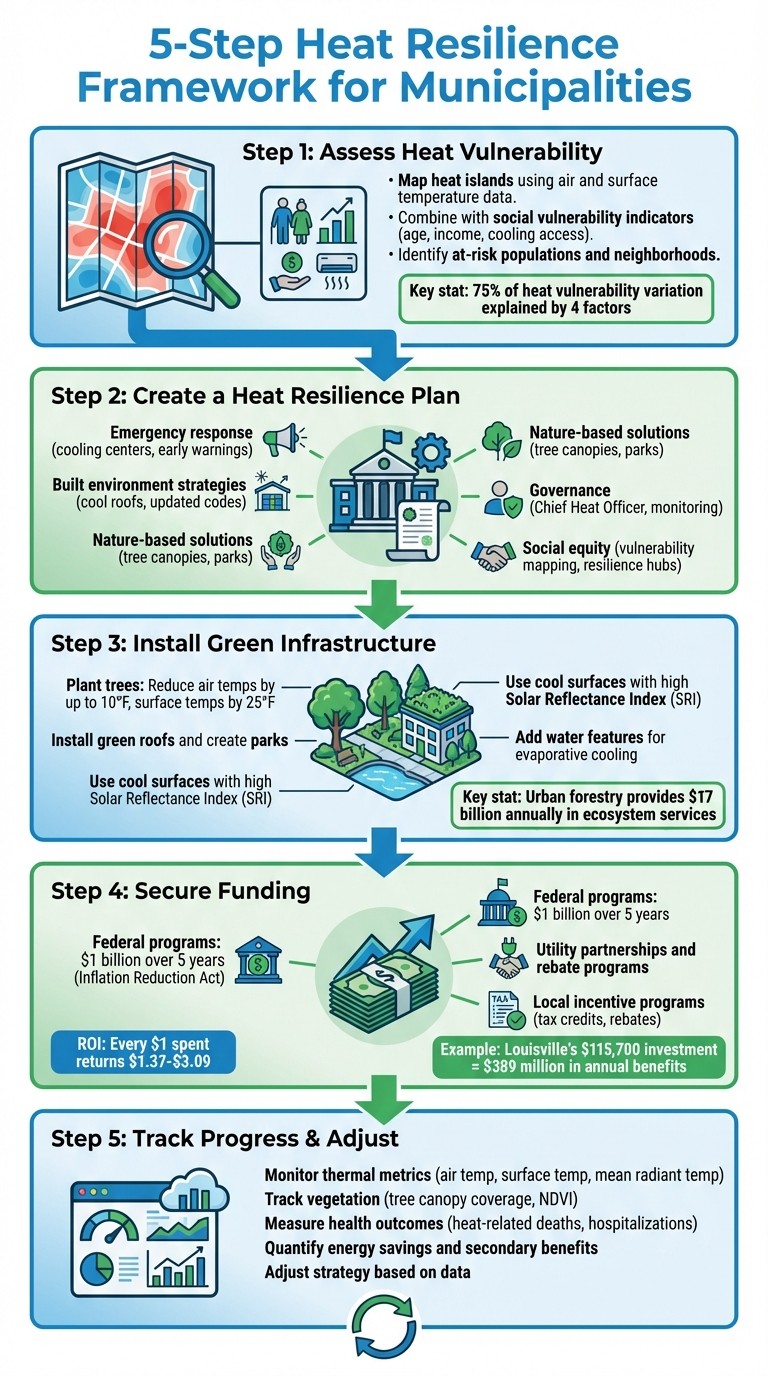
5-Step Heat Resilience Framework for Municipalities
Nature-based Solutions to Tackle Heat in Cities
Step 1: Assess Heat Vulnerability and Set Priorities
To tackle urban heat challenges effectively, municipalities need to map heat vulnerability and identify the populations most at risk. By using data-driven mapping, cities can move past assumptions and combine temperature measurements with social vulnerability data to pinpoint areas that require immediate attention. This approach ensures that interventions target the communities that need them most.
Map Heat Islands and At-Risk Areas
The first step is to establish clear goals for the heat assessment. Some cities may focus on energy impacts by comparing urban temperatures to surrounding rural areas, while others might prioritize public health by identifying hot spots within city limits.
For health-focused interventions, air temperature data is crucial because it reflects the actual heat exposure residents experience. This data can be collected through weather stations or mobile traverses, which use sensors to record temperatures along specific routes. For instance, Madison, Wisconsin, installed 150 temperature and humidity sensors on streetlight and utility poles between 2012 and 2013, creating a detailed city temperature map [8].
Surface temperature data, often gathered via satellites or aircraft, is particularly useful for identifying materials that contribute to heat, such as dark roofs and paved surfaces. Researchers at Arizona State University used MODIS and Landsat satellite data from 2000 to 2014 to monitor Phoenix's surface urban heat island. Their findings revealed that newly urbanized areas on the city's outskirts experienced the greatest temperature increases due to changing land use [8].
By combining air and surface temperature data with social vulnerability indicators - such as age, income, and access to cooling - cities can create detailed, multi-layered maps. Mapping at the neighborhood or census-tract level, rather than relying on city-wide averages, provides actionable insights. It's also important to consider nighttime temperatures, which can pose higher health risks since urban environments often retain heat, making it harder for the body to cool down [6][8].
Evaluate Community Heat Vulnerability
Heat vulnerability arises from the combination of three factors: exposure (the degree of potential harm), sensitivity (such as age or health conditions), and adaptive capacity (the ability to recover) [10]. These factors are influenced by demographic data (poverty, race, education), social conditions (isolation), infrastructure (air conditioning availability), and environmental features (like tree cover) [11].
A good example comes from Atlanta, where Georgia Tech helped map vulnerability across 247 neighborhoods. Their analysis ranked heat, flood, and mortality risks while tracking metrics like the number of trees needed to meet a 50% canopy goal [9]. Such insights not only shape heat-related interventions but also support urban greening initiatives. Research shows that four key factors - social and environmental vulnerability, social isolation, air conditioning access, and the proportion of elderly residents with pre-existing health conditions - account for over 75% of the variation in heat vulnerability [11]. Municipalities can use U.S. Census Bureau data to locate sensitive populations, including elderly residents, infants, and low-income communities [7].
Use Data to Guide Planning Decisions
The final step is transforming collected data into actionable plans. In July 2019, Boston analyzed data from a heat wave where temperatures peaked at 96.8°F. This study revealed that neighborhoods like Chinatown endured high-heat conditions for 37 consecutive hours, with nighttime temperatures exceeding 90°F. These findings directly informed the city's "Heat Resilience Solutions for Boston" plan, which outlined 26 specific strategies, such as targeting investments in environmental justice neighborhoods like Dorchester and Roxbury [12].
"Equitable heat resilience means putting people at the center." - City of Boston [12]
Several free tools can aid in this process. The CDC Heat & Health Tracker provides real-time heat-related illness data alongside National Weather Service forecasts, while the NOAA Climate Explorer offers interactive maps and graphs of past and future climate conditions at the county level [7][10]. By integrating hyper-local temperature data with social vulnerability indices, cities can prioritize investments that protect their most vulnerable residents and deliver meaningful public health improvements.
Step 2: Create a Heat Resilience Plan
Developing a heat resilience plan is essential for addressing both immediate emergencies and long-term strategies. A well-rounded plan combines emergency protocols, nature-based approaches, and updated policies, ensuring communities are protected during heat waves while systematically reducing urban heat over time. Below are the key elements to include in an effective heat resilience plan.
Key Components of a Heat Resilience Plan
A comprehensive plan should address five main areas:
Emergency response: Implement early warning systems, cooling centers, wellness checks, and hydration stations.
Built environment strategies: Use cool and green roofs, install cool pavements, and update building codes.
Nature-based solutions: Expand tree canopies, create parks, and establish green corridors.
Governance: Appoint a Chief Heat Officer and establish monitoring frameworks.
Social equity: Incorporate vulnerability mapping, establish resilience hubs, and provide utility assistance [14].
For example, Miami-Dade County appointed Jane Gilbert as the nation’s first Chief Heat Officer in April 2021. The county collaborated with nearly 300 residents and a Climate and Heat Health Task Force to create an Extreme Heat Action Plan. This plan includes 19 actions, such as retrofitting public housing with energy-efficient cooling systems and installing cool pavements in areas like walkways and parking lots [14]. Similarly, in March 2024, Phoenix passed Ordinance G-7241, requiring contractors to have heat illness prevention plans. The city also launched a grant program for tree planting in low-shade neighborhoods and set cooling standards for rental units through municipal code Chapter 39-5 [14].
"A heat action plan integrates a portfolio of assessments and actions to respond to and reduce heat-related impacts." - Heat Action Platform [14]
Work with the National Weather Service to define local heat wave thresholds and establish when to issue alerts or activate cooling centers [7]. Since the first heat wave of the season often poses the greatest risks, start public education campaigns in May. For outdoor and municipal workers, introduce a 7-to-14-day acclimatization schedule to gradually increase heat exposure [15].
Integrating Heat Resilience into Existing Plans
Incorporating heat resilience into current city frameworks - known as "mainstreaming" - can make interventions more feasible by aligning them with broader public health, air quality, and energy goals [16]. Seamlessly embedding these strategies into existing plans ensures maximum impact.
Update zoning and permitting regulations to require heat resilience documentation and incentivize cool roofs.
Incorporate shaded bus stops, cool pathways, and other heat-related considerations into transportation planning.
Modify public works projects to include green spaces and water bottle refill stations [7][12][16].
Establish an inter-departmental coordination group with representatives from public health, emergency management, transportation, and planning departments. This group should meet regularly and ensure resources like water, fans, and mobile cooling units are ready before the heat season begins [13].
Collaborating with Stakeholders and Building Partnerships
Engaging community members and stakeholders is crucial for creating an equitable and effective plan. Include municipal leaders, technical experts, and residents from heat-vulnerable areas, such as outdoor workers, older adults, and those with chronic health conditions or language barriers [12]. To encourage participation, offer stipends, provide childcare during meetings, and schedule sessions at accessible locations like community centers [10].
"By centering people and personal experiences alongside policies focused on infrastructure and buildings, we can deliver a wider range of strategies that can better address individual and systemic injustice and inequity." - City of Boston [12]
Partnerships with scientific and technical organizations can also enhance the plan. For example, Philadelphia collaborates with the National Weather Service to launch educational campaigns during heat alerts, ensuring timely public health messaging [7]. If funding is limited for monitoring project outcomes, consider partnering with local universities or high schools, as researchers often seek long-term data for academic purposes [10]. Toronto Public Health has also taken a proactive approach by hosting an annual Media Day in May to brief news outlets on the city’s heat response programs and resources [7].
Step 3: Install Green Infrastructure and Heat-Resistant Features
Once you've identified vulnerabilities and crafted a plan, the next step is to implement green infrastructure and heat-resistant materials. These additions help lower temperatures, improve air quality, and manage stormwater, creating a foundation for strategies that use natural systems to cool urban spaces.
Plant Trees, Install Green Roofs, and Create Parks
Trees serve as natural air conditioners in cities, capable of lowering air temperatures by up to 10°F and surface temperatures by as much as 25°F through shading and evapotranspiration [5]. Urban forestry in the U.S. provides an estimated $17 billion annually in ecosystem services, with every dollar spent on tree management yielding returns of $1.37 to $3.09 [5].
Start by conducting a tree canopy assessment using satellite imagery or remote sensing to pinpoint areas with sparse tree coverage and high heat exposure. Creating an urban forestry master plan that prioritizes these heat-prone zones - often overlapping with historically underserved neighborhoods - can ensure resources are directed where they're needed most. Choose tree species from approved lists that emphasize non-invasive, low-maintenance, and climate-adaptive varieties. This approach makes it easier to integrate tree planting into routine street upgrades and capital improvement projects.
Green roofs are another effective solution, cooling buildings directly while contributing to ambient cooling and reducing air pollution [4]. Financial incentives like Washington, D.C.'s RiverSmart Rooftops Green Roof Rebate Program and Philadelphia's Green Roof Tax Credit Program can help promote adoption of these systems.
Use Cool Surfaces and Heat-Resistant Materials
Dark roofs and pavements can intensify urban heat, raising temperatures by as much as 40% [1]. Cool surfaces, which use reflective materials to deflect sunlight and release absorbed heat, offer a practical way to combat this. Municipalities can enforce Solar Reflectance Index (SRI) standards through building codes and zoning regulations. For example, Atlanta's 2014 zoning requirements for certain districts mandated an initial SRI of 78 for low-sloped roofs [17].
Jurisdiction | Building Type | Minimum 3-Year Aged SRI |
|---|---|---|
Los Angeles, CA | Nonresidential (Low-sloped) | 82 |
Philadelphia, PA | Commercial/Industrial | 78 |
Phoenix, AZ | Commercial | 64 |
Baltimore, MD | New Construction (Low-sloped) | 78 |
Honolulu, HI | Residential (Low-sloped) | 64 |
Requiring clear labeling for roofing products - such as solar reflectance and emittance ratings verified by the Cool Roof Rating Council - ensures materials meet quality standards. For existing roofs, applying reflective coatings can significantly increase their albedo. In Salt Lake City, Utah, a project featuring an 865,000-square-foot white reflective vinyl roof demonstrated cooler surface temperatures compared to surrounding dark roofs, as shown through thermal imaging [1]. Additionally, permeable pavements, which allow water to seep through and evaporate, provide cooling benefits while reducing thermal pollution in runoff. Coordination with designers is essential to prevent tree roots from interfering with these systems.
Add Water Features and Natural Ventilation
Urban areas often lack the natural evaporation found in undeveloped landscapes, which contributes to elevated temperatures. Adding water features not only restores moisture but also helps cool the surrounding environment while managing stormwater. Combining cooling elements with water quality projects - such as incorporating trees and vegetation into roadside planters or green infiltration systems - can address both temperature reduction and stormwater management.
When designing these features, prioritize native, drought-resistant shade trees and groundcover to ensure they remain effective during heat waves. Tools like i-Tree can quantify benefits such as stormwater control and temperature reduction, making it easier to justify long-term investments. Incorporating these measures into routine street upgrades and capital projects ensures consistent funding and ongoing improvements.
Step 4: Secure Funding for Heat Resilience Projects
Securing funding is just as crucial as identifying vulnerabilities and implementing resilient infrastructure. Once green infrastructure is in place, ensuring financial support for its maintenance and expansion becomes the next priority.
Explore Funding Opportunities
There are numerous funding sources available to support urban greening and heat resilience projects:
Federal programs: Federal funding plays a major role in supporting urban greening efforts. For example, the U.S. Forest Service Urban and Community Forestry Program is a key source of federal dollars, with over $1 billion allocated over five years through the Inflation Reduction Act and Bipartisan Infrastructure Law specifically for urban forestry [5]. Additionally, the National Integrated Heat Health Information System (NIHHIS) has provided funding for extreme heat tabletop exercises from 2022 to 2025 [18].
Utility partnerships: Collaborations with utility companies can also be a valuable funding source. For instance, the Los Angeles Department of Water and Power works with City Plants to provide free shade trees to residents [2]. Similarly, the Sacramento Municipal Utility District partners with the Sacramento Tree Foundation to offer rebates for planting shade trees [2].
Local incentive programs: These initiatives often encourage property owners to contribute to citywide goals. For example, the District of Columbia’s RiverSmart Rooftops Green Roof Rebate Program offers financial support for green roof installations [4]. Philadelphia’s Green Roof Tax Credit Program allows businesses to offset construction costs against their taxes [4]. Some cities also fund greening efforts through stormwater fees on impervious surfaces or fines for tree removal [2].
Funding Type | Example Program | Primary Benefit |
|---|---|---|
Tax Credit | Philadelphia Green Roof Tax Credit | Reduces private-sector greening costs |
Rebate | DC RiverSmart Rooftops | Supports green roof installations |
Utility Partnership | Sacramento Municipal Utility District | Rebates for shade trees to lower energy bills |
Federal Grant | U.S. Forest Service Urban & Community Forestry | Funds master planning and tree planting |
Stormwater Fees | Various Municipalities | Funds green infrastructure via impervious fees |
These funding options can be seamlessly integrated into your heat resilience strategy, offering both economic and social benefits.
Build a Strong Case for Investment
A compelling case for investment often hinges on converting environmental goals into measurable financial and societal benefits:
Quantify the benefits: Highlighting the financial returns of green initiatives can make funding proposals more persuasive. For example, Louisville’s $115,700 investment in a tree canopy assessment revealed over $389 million in annual benefits from temperature regulation, energy savings, stormwater management, and increased property values [4]. Tools like i-Tree, developed by the U.S. Forest Service, can help calculate the monetary value of environmental benefits such as energy conservation, air quality improvements, and property value growth [4]. Urban forestry in the U.S. generates $17 billion annually in ecosystem services, with every $1 spent on tree management yielding returns between $1.37 and $3.09[5].
Connect greening to public health: Linking green infrastructure to health outcomes can further justify funding. For instance, heat-related hospitalizations in the U.S. surged by 51% in 2023 compared to 2018 [5]. Showing how trees can lower air temperatures by up to 10°F and surface temperatures by up to 25°F[5] ties these projects directly to reduced healthcare costs, strengthening the case for investment.
Emphasize Long-Term Benefits
Highlighting the sustained economic and social returns of heat resilience projects can secure ongoing funding:
Energy savings through shaded buildings: Trees that shade homes and businesses help cut cooling costs, reducing peak energy demand and benefiting both residents and utility companies.
Integrate green infrastructure into capital projects: Incorporating features like tree planting, permeable pavements, and green infiltration systems into routine street upgrades ensures that heat resilience becomes a standard part of infrastructure planning, spreading costs across existing budgets.
Address equity goals: Prioritizing areas disproportionately affected by heat can unlock funding tied to equity initiatives. Tools like the Tree Equity Score can help identify vulnerable neighborhoods [2]. Many grant programs now favor projects that address historical inequities, making equity analysis a critical component of successful applications. Partnering with organizations like park and stormwater agencies can also help share costs and expand green infrastructure on public lands [4].
Step 5: Track Progress and Adjust Your Approach
Monitoring project performance is essential to assess whether investments are delivering the desired outcomes.
Choose the Right Performance Metrics
To track progress effectively, use a combination of thermal, health, and vegetation metrics. Tools like sensors, satellite imagery, and modeling can help monitor Air Temperature (Ta), Land Surface Temperature (LST), and Mean Radiant Temperature (MRT). Additionally, comfort indicators such as the Universal Thermal Climate Index (UTCI) or Physiological Equivalent Temperature (PET) provide insights into how residents experience heat [19][21].
For vegetation, metrics like Tree Canopy Coverage and the Normalized Difference Vegetation Index (NDVI), measured through remote sensing, can quantify greening efforts [19][21]. Health metrics are equally important: collaborate with public health agencies to track data on heat-related deaths, hospitalizations, and ambulance responses. Heat remains the top weather-related cause of death in the U.S., with an average of 702 fatalities annually between 2004 and 2018 [20][22]. These figures highlight the importance of health data in evaluating project success.
Measure Benefits
Deploy heat sensors strategically to gather real-time data, which helps in tracking temperature reductions at specific sites [12]. Tools like i-Tree can quantify the monetary and environmental benefits of tree canopies. For example, Louisville demonstrated that its tree canopy generates over $389 million annually in benefits [4]. Additionally, monitor secondary benefits such as improved stormwater management and enhanced biodiversity to strengthen the case for further investment [21].
Energy savings are another critical metric. Shaded buildings can significantly cut cooling costs and reduce peak energy demand. Utility billing data can provide a clear picture of these savings [21][3]. These measurements not only demonstrate progress but also help identify when strategies need fine-tuning.
Adjust Your Strategy Based on Results
If metrics reveal gaps in performance, adapt your approach. For instance, low tree survival rates may require revising species selections to prioritize climate-resilient, drought-tolerant, and non-invasive varieties. Tools like the Tree Equity Score or NIHHIS Heat Equity Mapper can pinpoint neighborhoods lacking sufficient tree cover. If voluntary measures fall short, consider implementing minimum vegetative cover standards [2][4][6].
A proactive example comes from Chicago, where an enhanced heat response program reduced heat-related deaths from 700 to just 100 [7]. Regular assessments, such as remote sensing of canopy coverage, can identify areas where interventions are underperforming, ensuring resources are directed where they are most needed [2].
Conclusion: Creating Cooler, Greener Cities
Core Steps for Municipal Success
Building heat resilience begins with thorough, data-driven evaluations and continues with consistent monitoring. Cities that excel in this area start by identifying their most vulnerable neighborhoods through detailed tree canopy assessments and heat mapping. From there, they craft comprehensive plans that weave greening efforts into the fabric of current city operations. Strategic tree management proves to be a highly effective investment, and federal programs offer considerable support to help cities implement these initiatives.
The best results come from blending nature-based solutions with smart policy measures. For instance, trees can reduce air temperatures by as much as 10°F and surface temperatures by up to 25°F, addressing both public health concerns and equity issues [5]. However, relying solely on voluntary programs isn’t enough. Cities that succeed combine incentives - like rebates and free tree distribution programs - with regulatory tools, such as zoning rules that require a minimum level of vegetation. Los Angeles serves as a strong example, working through its City Plants initiative to provide free shade trees to residents while also pursuing ambitious long-term canopy goals [2].
Why Leadership and Vision Matter
Achieving lasting success in heat resilience hinges on forward-thinking leadership that embeds these strategies into routine city planning.
Bold, coordinated leadership and sustained commitment are essential for effective heat resilience. Without decisive action, cities like Boston could face a dramatic rise in scorching days, with annual occurrences of temperatures over 90°F jumping from 10 per year historically to as many as 46–60 days by the 2070s [12]. Strong leadership is particularly critical in addressing temperature disparities in neighborhoods that have historically lacked adequate tree coverage.
Louisville offers a compelling example of this kind of leadership. In 2014, Mayor Fischer allocated $115,700 for a detailed tree canopy assessment. These strategic evaluations help identify critical gaps and provide the data necessary to direct investments down to the street level [4]. Such evidence-based leadership transforms heat resilience from a peripheral concern into a key element of urban planning. With heat-related hospitalizations surging by 51% in 2023 compared to 2018 [5], the need for bold action has never been clearer. This kind of visionary leadership turns urban planning into a proactive defense against rising temperatures.
FAQs
How can municipalities identify and prioritize areas for urban greening and heat resilience projects?
Municipalities can tackle urban heat and enhance green spaces by identifying neighborhoods that face the greatest heat exposure and lack vegetation. Using tools like tree canopy studies, heat island mapping, and land cover analysis, they can pinpoint areas where green infrastructure - such as parks, trees, or green roofs - can make the biggest difference.
It's also essential to address equity by prioritizing underserved communities or neighborhoods with environmental or socioeconomic challenges. Pairing these data-driven insights with feedback from local residents allows cities to plan projects that not only reduce urban heat but also improve overall quality of life for those who need it most.
What funding options are available for cities to support heat resilience and urban greening projects?
Cities have access to a variety of funding sources to bolster heat resilience and urban greening initiatives, many of which stem from federal programs and grants. One prominent option is the Hazard Mitigation Assistance (HMA) grants, which support projects like green infrastructure and heat-resistant urban designs aimed at mitigating the effects of rising temperatures in urban areas. Similarly, the Inflation Reduction Act and the Bipartisan Infrastructure Law offer funding for efforts such as community heat monitoring and upgrading infrastructure to better withstand extreme heat.
Programs like the Center for Collaborative Heat Monitoring provide grants to empower communities to collect and analyze heat-related data, helping them develop localized solutions. Federal agencies, including the EPA, also play a role by offering funding and technical support for strategies such as urban forestry, green roofs, and cool pavements. These resources allow cities to design and implement targeted projects that effectively address their specific climate challenges.
What are the best ways for cities to measure and track the success of their heat resilience efforts?
Cities can evaluate the impact of their heat resilience strategies by blending technology-driven insights with community input. Creating scorecards to measure policy outcomes - such as reductions in surface temperatures, expanded green spaces, or the adoption of cooling solutions like green roofs - offers clear markers of progress.
Key areas to track include shifts in urban temperature levels, public health data like the frequency of heat-related illnesses, and patterns in energy consumption. Gathering regular feedback from residents and maintaining tools like heat alerts or early warning systems can further refine these efforts. Together, these approaches allow cities to pinpoint weaknesses, make informed adjustments, and showcase the real-world benefits of their resilience plans.
Related Blog Posts
Latest Articles
©2025


FAQ
01
What does it really mean to “redefine profit”?
02
What makes Council Fire different?
03
Who does Council Fire you work with?
04
What does working with Council Fire actually look like?
05
How does Council Fire help organizations turn big goals into action?
06
How does Council Fire define and measure success?
Jan 30, 2026
How to Build Heat Resilience & Urban Greening for Municipalities & Government Agencies
Sustainability Strategy
In This Article
Guide for municipalities to map heat vulnerability, expand urban greening, secure funding, and track outcomes to reduce heat risks and improve equity.
How to Build Heat Resilience & Urban Greening for Municipalities & Government Agencies
Urban areas in the U.S. are heating up faster than rural regions, creating public health challenges and economic strain. Cities are hotter due to the Urban Heat Island (UHI) effect, where materials like asphalt and concrete trap heat, and the lack of greenery worsens the problem. Vulnerable groups, such as low-income communities and the elderly, face the greatest risks.
Key strategies to combat urban heat include:
Urban greening: Trees and vegetation can reduce air temperatures by up to 10°F and surface temperatures by 25°F, while also improving air quality and lowering energy costs.
Heat resilience plans: Cities should prioritize vulnerable neighborhoods, use data-driven mapping, and integrate cooling measures like shaded areas, cool roofs, and green infrastructure into planning.
Funding opportunities: Federal programs (e.g., Inflation Reduction Act) and local initiatives offer financial support for urban forestry and cooling projects.
Performance tracking: Use tools like sensors and satellite imagery to measure temperature changes, tree coverage, and health outcomes.
Cities like Louisville and Boston are leading by using data to guide investments in tree canopies and heat-resilient infrastructure. With federal funding and community-driven planning, municipalities can protect residents, reduce energy use, and improve urban living conditions.
5-Step Heat Resilience Framework for Municipalities
Nature-based Solutions to Tackle Heat in Cities
Step 1: Assess Heat Vulnerability and Set Priorities
To tackle urban heat challenges effectively, municipalities need to map heat vulnerability and identify the populations most at risk. By using data-driven mapping, cities can move past assumptions and combine temperature measurements with social vulnerability data to pinpoint areas that require immediate attention. This approach ensures that interventions target the communities that need them most.
Map Heat Islands and At-Risk Areas
The first step is to establish clear goals for the heat assessment. Some cities may focus on energy impacts by comparing urban temperatures to surrounding rural areas, while others might prioritize public health by identifying hot spots within city limits.
For health-focused interventions, air temperature data is crucial because it reflects the actual heat exposure residents experience. This data can be collected through weather stations or mobile traverses, which use sensors to record temperatures along specific routes. For instance, Madison, Wisconsin, installed 150 temperature and humidity sensors on streetlight and utility poles between 2012 and 2013, creating a detailed city temperature map [8].
Surface temperature data, often gathered via satellites or aircraft, is particularly useful for identifying materials that contribute to heat, such as dark roofs and paved surfaces. Researchers at Arizona State University used MODIS and Landsat satellite data from 2000 to 2014 to monitor Phoenix's surface urban heat island. Their findings revealed that newly urbanized areas on the city's outskirts experienced the greatest temperature increases due to changing land use [8].
By combining air and surface temperature data with social vulnerability indicators - such as age, income, and access to cooling - cities can create detailed, multi-layered maps. Mapping at the neighborhood or census-tract level, rather than relying on city-wide averages, provides actionable insights. It's also important to consider nighttime temperatures, which can pose higher health risks since urban environments often retain heat, making it harder for the body to cool down [6][8].
Evaluate Community Heat Vulnerability
Heat vulnerability arises from the combination of three factors: exposure (the degree of potential harm), sensitivity (such as age or health conditions), and adaptive capacity (the ability to recover) [10]. These factors are influenced by demographic data (poverty, race, education), social conditions (isolation), infrastructure (air conditioning availability), and environmental features (like tree cover) [11].
A good example comes from Atlanta, where Georgia Tech helped map vulnerability across 247 neighborhoods. Their analysis ranked heat, flood, and mortality risks while tracking metrics like the number of trees needed to meet a 50% canopy goal [9]. Such insights not only shape heat-related interventions but also support urban greening initiatives. Research shows that four key factors - social and environmental vulnerability, social isolation, air conditioning access, and the proportion of elderly residents with pre-existing health conditions - account for over 75% of the variation in heat vulnerability [11]. Municipalities can use U.S. Census Bureau data to locate sensitive populations, including elderly residents, infants, and low-income communities [7].
Use Data to Guide Planning Decisions
The final step is transforming collected data into actionable plans. In July 2019, Boston analyzed data from a heat wave where temperatures peaked at 96.8°F. This study revealed that neighborhoods like Chinatown endured high-heat conditions for 37 consecutive hours, with nighttime temperatures exceeding 90°F. These findings directly informed the city's "Heat Resilience Solutions for Boston" plan, which outlined 26 specific strategies, such as targeting investments in environmental justice neighborhoods like Dorchester and Roxbury [12].
"Equitable heat resilience means putting people at the center." - City of Boston [12]
Several free tools can aid in this process. The CDC Heat & Health Tracker provides real-time heat-related illness data alongside National Weather Service forecasts, while the NOAA Climate Explorer offers interactive maps and graphs of past and future climate conditions at the county level [7][10]. By integrating hyper-local temperature data with social vulnerability indices, cities can prioritize investments that protect their most vulnerable residents and deliver meaningful public health improvements.
Step 2: Create a Heat Resilience Plan
Developing a heat resilience plan is essential for addressing both immediate emergencies and long-term strategies. A well-rounded plan combines emergency protocols, nature-based approaches, and updated policies, ensuring communities are protected during heat waves while systematically reducing urban heat over time. Below are the key elements to include in an effective heat resilience plan.
Key Components of a Heat Resilience Plan
A comprehensive plan should address five main areas:
Emergency response: Implement early warning systems, cooling centers, wellness checks, and hydration stations.
Built environment strategies: Use cool and green roofs, install cool pavements, and update building codes.
Nature-based solutions: Expand tree canopies, create parks, and establish green corridors.
Governance: Appoint a Chief Heat Officer and establish monitoring frameworks.
Social equity: Incorporate vulnerability mapping, establish resilience hubs, and provide utility assistance [14].
For example, Miami-Dade County appointed Jane Gilbert as the nation’s first Chief Heat Officer in April 2021. The county collaborated with nearly 300 residents and a Climate and Heat Health Task Force to create an Extreme Heat Action Plan. This plan includes 19 actions, such as retrofitting public housing with energy-efficient cooling systems and installing cool pavements in areas like walkways and parking lots [14]. Similarly, in March 2024, Phoenix passed Ordinance G-7241, requiring contractors to have heat illness prevention plans. The city also launched a grant program for tree planting in low-shade neighborhoods and set cooling standards for rental units through municipal code Chapter 39-5 [14].
"A heat action plan integrates a portfolio of assessments and actions to respond to and reduce heat-related impacts." - Heat Action Platform [14]
Work with the National Weather Service to define local heat wave thresholds and establish when to issue alerts or activate cooling centers [7]. Since the first heat wave of the season often poses the greatest risks, start public education campaigns in May. For outdoor and municipal workers, introduce a 7-to-14-day acclimatization schedule to gradually increase heat exposure [15].
Integrating Heat Resilience into Existing Plans
Incorporating heat resilience into current city frameworks - known as "mainstreaming" - can make interventions more feasible by aligning them with broader public health, air quality, and energy goals [16]. Seamlessly embedding these strategies into existing plans ensures maximum impact.
Update zoning and permitting regulations to require heat resilience documentation and incentivize cool roofs.
Incorporate shaded bus stops, cool pathways, and other heat-related considerations into transportation planning.
Modify public works projects to include green spaces and water bottle refill stations [7][12][16].
Establish an inter-departmental coordination group with representatives from public health, emergency management, transportation, and planning departments. This group should meet regularly and ensure resources like water, fans, and mobile cooling units are ready before the heat season begins [13].
Collaborating with Stakeholders and Building Partnerships
Engaging community members and stakeholders is crucial for creating an equitable and effective plan. Include municipal leaders, technical experts, and residents from heat-vulnerable areas, such as outdoor workers, older adults, and those with chronic health conditions or language barriers [12]. To encourage participation, offer stipends, provide childcare during meetings, and schedule sessions at accessible locations like community centers [10].
"By centering people and personal experiences alongside policies focused on infrastructure and buildings, we can deliver a wider range of strategies that can better address individual and systemic injustice and inequity." - City of Boston [12]
Partnerships with scientific and technical organizations can also enhance the plan. For example, Philadelphia collaborates with the National Weather Service to launch educational campaigns during heat alerts, ensuring timely public health messaging [7]. If funding is limited for monitoring project outcomes, consider partnering with local universities or high schools, as researchers often seek long-term data for academic purposes [10]. Toronto Public Health has also taken a proactive approach by hosting an annual Media Day in May to brief news outlets on the city’s heat response programs and resources [7].
Step 3: Install Green Infrastructure and Heat-Resistant Features
Once you've identified vulnerabilities and crafted a plan, the next step is to implement green infrastructure and heat-resistant materials. These additions help lower temperatures, improve air quality, and manage stormwater, creating a foundation for strategies that use natural systems to cool urban spaces.
Plant Trees, Install Green Roofs, and Create Parks
Trees serve as natural air conditioners in cities, capable of lowering air temperatures by up to 10°F and surface temperatures by as much as 25°F through shading and evapotranspiration [5]. Urban forestry in the U.S. provides an estimated $17 billion annually in ecosystem services, with every dollar spent on tree management yielding returns of $1.37 to $3.09 [5].
Start by conducting a tree canopy assessment using satellite imagery or remote sensing to pinpoint areas with sparse tree coverage and high heat exposure. Creating an urban forestry master plan that prioritizes these heat-prone zones - often overlapping with historically underserved neighborhoods - can ensure resources are directed where they're needed most. Choose tree species from approved lists that emphasize non-invasive, low-maintenance, and climate-adaptive varieties. This approach makes it easier to integrate tree planting into routine street upgrades and capital improvement projects.
Green roofs are another effective solution, cooling buildings directly while contributing to ambient cooling and reducing air pollution [4]. Financial incentives like Washington, D.C.'s RiverSmart Rooftops Green Roof Rebate Program and Philadelphia's Green Roof Tax Credit Program can help promote adoption of these systems.
Use Cool Surfaces and Heat-Resistant Materials
Dark roofs and pavements can intensify urban heat, raising temperatures by as much as 40% [1]. Cool surfaces, which use reflective materials to deflect sunlight and release absorbed heat, offer a practical way to combat this. Municipalities can enforce Solar Reflectance Index (SRI) standards through building codes and zoning regulations. For example, Atlanta's 2014 zoning requirements for certain districts mandated an initial SRI of 78 for low-sloped roofs [17].
Jurisdiction | Building Type | Minimum 3-Year Aged SRI |
|---|---|---|
Los Angeles, CA | Nonresidential (Low-sloped) | 82 |
Philadelphia, PA | Commercial/Industrial | 78 |
Phoenix, AZ | Commercial | 64 |
Baltimore, MD | New Construction (Low-sloped) | 78 |
Honolulu, HI | Residential (Low-sloped) | 64 |
Requiring clear labeling for roofing products - such as solar reflectance and emittance ratings verified by the Cool Roof Rating Council - ensures materials meet quality standards. For existing roofs, applying reflective coatings can significantly increase their albedo. In Salt Lake City, Utah, a project featuring an 865,000-square-foot white reflective vinyl roof demonstrated cooler surface temperatures compared to surrounding dark roofs, as shown through thermal imaging [1]. Additionally, permeable pavements, which allow water to seep through and evaporate, provide cooling benefits while reducing thermal pollution in runoff. Coordination with designers is essential to prevent tree roots from interfering with these systems.
Add Water Features and Natural Ventilation
Urban areas often lack the natural evaporation found in undeveloped landscapes, which contributes to elevated temperatures. Adding water features not only restores moisture but also helps cool the surrounding environment while managing stormwater. Combining cooling elements with water quality projects - such as incorporating trees and vegetation into roadside planters or green infiltration systems - can address both temperature reduction and stormwater management.
When designing these features, prioritize native, drought-resistant shade trees and groundcover to ensure they remain effective during heat waves. Tools like i-Tree can quantify benefits such as stormwater control and temperature reduction, making it easier to justify long-term investments. Incorporating these measures into routine street upgrades and capital projects ensures consistent funding and ongoing improvements.
Step 4: Secure Funding for Heat Resilience Projects
Securing funding is just as crucial as identifying vulnerabilities and implementing resilient infrastructure. Once green infrastructure is in place, ensuring financial support for its maintenance and expansion becomes the next priority.
Explore Funding Opportunities
There are numerous funding sources available to support urban greening and heat resilience projects:
Federal programs: Federal funding plays a major role in supporting urban greening efforts. For example, the U.S. Forest Service Urban and Community Forestry Program is a key source of federal dollars, with over $1 billion allocated over five years through the Inflation Reduction Act and Bipartisan Infrastructure Law specifically for urban forestry [5]. Additionally, the National Integrated Heat Health Information System (NIHHIS) has provided funding for extreme heat tabletop exercises from 2022 to 2025 [18].
Utility partnerships: Collaborations with utility companies can also be a valuable funding source. For instance, the Los Angeles Department of Water and Power works with City Plants to provide free shade trees to residents [2]. Similarly, the Sacramento Municipal Utility District partners with the Sacramento Tree Foundation to offer rebates for planting shade trees [2].
Local incentive programs: These initiatives often encourage property owners to contribute to citywide goals. For example, the District of Columbia’s RiverSmart Rooftops Green Roof Rebate Program offers financial support for green roof installations [4]. Philadelphia’s Green Roof Tax Credit Program allows businesses to offset construction costs against their taxes [4]. Some cities also fund greening efforts through stormwater fees on impervious surfaces or fines for tree removal [2].
Funding Type | Example Program | Primary Benefit |
|---|---|---|
Tax Credit | Philadelphia Green Roof Tax Credit | Reduces private-sector greening costs |
Rebate | DC RiverSmart Rooftops | Supports green roof installations |
Utility Partnership | Sacramento Municipal Utility District | Rebates for shade trees to lower energy bills |
Federal Grant | U.S. Forest Service Urban & Community Forestry | Funds master planning and tree planting |
Stormwater Fees | Various Municipalities | Funds green infrastructure via impervious fees |
These funding options can be seamlessly integrated into your heat resilience strategy, offering both economic and social benefits.
Build a Strong Case for Investment
A compelling case for investment often hinges on converting environmental goals into measurable financial and societal benefits:
Quantify the benefits: Highlighting the financial returns of green initiatives can make funding proposals more persuasive. For example, Louisville’s $115,700 investment in a tree canopy assessment revealed over $389 million in annual benefits from temperature regulation, energy savings, stormwater management, and increased property values [4]. Tools like i-Tree, developed by the U.S. Forest Service, can help calculate the monetary value of environmental benefits such as energy conservation, air quality improvements, and property value growth [4]. Urban forestry in the U.S. generates $17 billion annually in ecosystem services, with every $1 spent on tree management yielding returns between $1.37 and $3.09[5].
Connect greening to public health: Linking green infrastructure to health outcomes can further justify funding. For instance, heat-related hospitalizations in the U.S. surged by 51% in 2023 compared to 2018 [5]. Showing how trees can lower air temperatures by up to 10°F and surface temperatures by up to 25°F[5] ties these projects directly to reduced healthcare costs, strengthening the case for investment.
Emphasize Long-Term Benefits
Highlighting the sustained economic and social returns of heat resilience projects can secure ongoing funding:
Energy savings through shaded buildings: Trees that shade homes and businesses help cut cooling costs, reducing peak energy demand and benefiting both residents and utility companies.
Integrate green infrastructure into capital projects: Incorporating features like tree planting, permeable pavements, and green infiltration systems into routine street upgrades ensures that heat resilience becomes a standard part of infrastructure planning, spreading costs across existing budgets.
Address equity goals: Prioritizing areas disproportionately affected by heat can unlock funding tied to equity initiatives. Tools like the Tree Equity Score can help identify vulnerable neighborhoods [2]. Many grant programs now favor projects that address historical inequities, making equity analysis a critical component of successful applications. Partnering with organizations like park and stormwater agencies can also help share costs and expand green infrastructure on public lands [4].
Step 5: Track Progress and Adjust Your Approach
Monitoring project performance is essential to assess whether investments are delivering the desired outcomes.
Choose the Right Performance Metrics
To track progress effectively, use a combination of thermal, health, and vegetation metrics. Tools like sensors, satellite imagery, and modeling can help monitor Air Temperature (Ta), Land Surface Temperature (LST), and Mean Radiant Temperature (MRT). Additionally, comfort indicators such as the Universal Thermal Climate Index (UTCI) or Physiological Equivalent Temperature (PET) provide insights into how residents experience heat [19][21].
For vegetation, metrics like Tree Canopy Coverage and the Normalized Difference Vegetation Index (NDVI), measured through remote sensing, can quantify greening efforts [19][21]. Health metrics are equally important: collaborate with public health agencies to track data on heat-related deaths, hospitalizations, and ambulance responses. Heat remains the top weather-related cause of death in the U.S., with an average of 702 fatalities annually between 2004 and 2018 [20][22]. These figures highlight the importance of health data in evaluating project success.
Measure Benefits
Deploy heat sensors strategically to gather real-time data, which helps in tracking temperature reductions at specific sites [12]. Tools like i-Tree can quantify the monetary and environmental benefits of tree canopies. For example, Louisville demonstrated that its tree canopy generates over $389 million annually in benefits [4]. Additionally, monitor secondary benefits such as improved stormwater management and enhanced biodiversity to strengthen the case for further investment [21].
Energy savings are another critical metric. Shaded buildings can significantly cut cooling costs and reduce peak energy demand. Utility billing data can provide a clear picture of these savings [21][3]. These measurements not only demonstrate progress but also help identify when strategies need fine-tuning.
Adjust Your Strategy Based on Results
If metrics reveal gaps in performance, adapt your approach. For instance, low tree survival rates may require revising species selections to prioritize climate-resilient, drought-tolerant, and non-invasive varieties. Tools like the Tree Equity Score or NIHHIS Heat Equity Mapper can pinpoint neighborhoods lacking sufficient tree cover. If voluntary measures fall short, consider implementing minimum vegetative cover standards [2][4][6].
A proactive example comes from Chicago, where an enhanced heat response program reduced heat-related deaths from 700 to just 100 [7]. Regular assessments, such as remote sensing of canopy coverage, can identify areas where interventions are underperforming, ensuring resources are directed where they are most needed [2].
Conclusion: Creating Cooler, Greener Cities
Core Steps for Municipal Success
Building heat resilience begins with thorough, data-driven evaluations and continues with consistent monitoring. Cities that excel in this area start by identifying their most vulnerable neighborhoods through detailed tree canopy assessments and heat mapping. From there, they craft comprehensive plans that weave greening efforts into the fabric of current city operations. Strategic tree management proves to be a highly effective investment, and federal programs offer considerable support to help cities implement these initiatives.
The best results come from blending nature-based solutions with smart policy measures. For instance, trees can reduce air temperatures by as much as 10°F and surface temperatures by up to 25°F, addressing both public health concerns and equity issues [5]. However, relying solely on voluntary programs isn’t enough. Cities that succeed combine incentives - like rebates and free tree distribution programs - with regulatory tools, such as zoning rules that require a minimum level of vegetation. Los Angeles serves as a strong example, working through its City Plants initiative to provide free shade trees to residents while also pursuing ambitious long-term canopy goals [2].
Why Leadership and Vision Matter
Achieving lasting success in heat resilience hinges on forward-thinking leadership that embeds these strategies into routine city planning.
Bold, coordinated leadership and sustained commitment are essential for effective heat resilience. Without decisive action, cities like Boston could face a dramatic rise in scorching days, with annual occurrences of temperatures over 90°F jumping from 10 per year historically to as many as 46–60 days by the 2070s [12]. Strong leadership is particularly critical in addressing temperature disparities in neighborhoods that have historically lacked adequate tree coverage.
Louisville offers a compelling example of this kind of leadership. In 2014, Mayor Fischer allocated $115,700 for a detailed tree canopy assessment. These strategic evaluations help identify critical gaps and provide the data necessary to direct investments down to the street level [4]. Such evidence-based leadership transforms heat resilience from a peripheral concern into a key element of urban planning. With heat-related hospitalizations surging by 51% in 2023 compared to 2018 [5], the need for bold action has never been clearer. This kind of visionary leadership turns urban planning into a proactive defense against rising temperatures.
FAQs
How can municipalities identify and prioritize areas for urban greening and heat resilience projects?
Municipalities can tackle urban heat and enhance green spaces by identifying neighborhoods that face the greatest heat exposure and lack vegetation. Using tools like tree canopy studies, heat island mapping, and land cover analysis, they can pinpoint areas where green infrastructure - such as parks, trees, or green roofs - can make the biggest difference.
It's also essential to address equity by prioritizing underserved communities or neighborhoods with environmental or socioeconomic challenges. Pairing these data-driven insights with feedback from local residents allows cities to plan projects that not only reduce urban heat but also improve overall quality of life for those who need it most.
What funding options are available for cities to support heat resilience and urban greening projects?
Cities have access to a variety of funding sources to bolster heat resilience and urban greening initiatives, many of which stem from federal programs and grants. One prominent option is the Hazard Mitigation Assistance (HMA) grants, which support projects like green infrastructure and heat-resistant urban designs aimed at mitigating the effects of rising temperatures in urban areas. Similarly, the Inflation Reduction Act and the Bipartisan Infrastructure Law offer funding for efforts such as community heat monitoring and upgrading infrastructure to better withstand extreme heat.
Programs like the Center for Collaborative Heat Monitoring provide grants to empower communities to collect and analyze heat-related data, helping them develop localized solutions. Federal agencies, including the EPA, also play a role by offering funding and technical support for strategies such as urban forestry, green roofs, and cool pavements. These resources allow cities to design and implement targeted projects that effectively address their specific climate challenges.
What are the best ways for cities to measure and track the success of their heat resilience efforts?
Cities can evaluate the impact of their heat resilience strategies by blending technology-driven insights with community input. Creating scorecards to measure policy outcomes - such as reductions in surface temperatures, expanded green spaces, or the adoption of cooling solutions like green roofs - offers clear markers of progress.
Key areas to track include shifts in urban temperature levels, public health data like the frequency of heat-related illnesses, and patterns in energy consumption. Gathering regular feedback from residents and maintaining tools like heat alerts or early warning systems can further refine these efforts. Together, these approaches allow cities to pinpoint weaknesses, make informed adjustments, and showcase the real-world benefits of their resilience plans.
Related Blog Posts
FAQ
What does it really mean to “redefine profit”?
What makes Council Fire different?
Who does Council Fire you work with?
What does working with Council Fire actually look like?
How does Council Fire help organizations turn big goals into action?
How does Council Fire define and measure success?