
Jan 29, 2026
How to Design Coastal Resilience & Flood Mitigation for Universities & Research Institutions
Sustainability Strategy
In This Article
Practical guidance on assessing coastal flood risks, using nature-based defenses and engineered solutions, and aligning campus policy and stakeholders for long-term protection.
How to Design Coastal Resilience & Flood Mitigation for Universities & Research Institutions
Universities near coastlines face growing risks from rising sea levels and extreme weather. Flooding can damage critical infrastructure, disrupt operations, and jeopardize research. To address these challenges, campuses must adopt specialized strategies that combine advanced modeling, tailored infrastructure, and nature-based solutions. Key measures include:
Assessing Risks: Use tools like hydrodynamic models and hazard mapping to identify vulnerable areas, such as underground utilities and basements.
Targeted Infrastructure: Install floodwalls, submarine doors, and improved drainage systems to protect high-risk facilities.
Nature-Based Solutions: Implement living shorelines, rain gardens, and bioswales to manage stormwater and reduce wave energy.
Future Planning: Incorporate localized climate projections to guide construction and upgrades, ensuring long-term protection.
Stakeholder Collaboration: Work with local governments, students, and experts to align campus efforts with regional resilience goals.
Proactive investment in these strategies can save universities from future repair costs, protect academic resources, and maintain operational continuity during climate-related events.
How to Assess Coastal Flood Risks on Campus
Using Hazard Mapping and Modeling Tools
Universities need reliable tools to model how flooding might impact their campuses. By combining various technologies, they can create a comprehensive understanding of potential risks.
Hydrodynamic models like XBeach simulate how waves move across campus grounds, overtop barriers, and flood specific areas [6]. Similarly, the Advanced CIRCulation (ADCIRC) model predicts storm surge patterns and tidal impacts. While these models require significant computational resources, surrogate models - using methods like Gene Expression Programming - allow for quicker testing of thousands of scenarios [6].
The U.S. Geological Survey provides the Coastal Change Hazards Portal, which organizes data into three main categories: present-day storm scenarios that show dune erosion and inundation, historical shoreline change patterns, and assessments of vulnerability to sea-level rise [4][5]. This portal uses the Coastal Vulnerability Index (CVI) to assess risk factors such as tidal range, wave height, and coastal slope.
For tailored campus planning, universities should downscale global climate models to create localized projections that align with municipal regulations [3][2]. These projections make broad climate data actionable for campus planners. Universities can develop dynamic two-dimensional models that incorporate campus-specific details - like new building projects and underground utilities - into city-scale flood risk assessments. This approach ensures that risks from precipitation, river flooding, and sea-level rise are examined holistically [3]. With these advanced tools highlighting flood patterns, the next step involves identifying vulnerable campus infrastructure.
Identifying Physical and Operational Weak Points
Physical inspections and on-ground assessments complement modeling efforts, helping to create a complete risk profile. Once the modeling tools are in place, the focus shifts to identifying specific vulnerabilities on campus. This requires both advanced analysis and careful physical evaluations.
One effective method is what MIT refers to as a "Building Porosity Hunt" - a detailed inspection of campus structures to locate areas where water might enter during floods [3]. This includes examining basement windows, utility access points, loading docks, and other openings below potential flood levels. Special attention should be given to underground utility systems, as flooding in these areas can disrupt power, heating, and cooling across multiple buildings.
The assessment should also evaluate whether existing drainage and stormwater systems can handle intense "cloud burst" rainfall (lasting 1–3 hours) as well as prolonged 24-hour rain events [3]. Many campuses discover that their infrastructure was designed for outdated weather patterns and cannot handle current or future conditions. Critical facilities like labs, libraries, and power systems often require immediate protection because they house vital research, equipment, and services.
Using the Coastal Vulnerability Index provides a structured way to quantify risks based on physical factors such as slope and geomorphology, while also considering the campus's natural adaptability [4]. This helps prioritize areas needing immediate attention versus those that can be addressed in the long term. These physical assessments are essential for integrating future climate projections into campus planning.
Using Future Climate Projections in Planning
Relying solely on historical flood data is no longer sufficient. Climate change is altering the frequency and intensity of flooding, making forward-looking projections critical for effective campus planning.
Projections show that extreme rainfall events are becoming more frequent. Coastal defenses, such as the Charles River Dam protecting MIT's campus, were not designed to account for rising sea levels and may face overtopping risks within the next 20 to 30 years [3].
It’s important to evaluate risks over multiple timeframes - such as 2030, 2050, and 2100 - to align with the varying lifespans of campus assets [7]. For example, a building constructed today may still be in use when sea levels are 4 feet higher than they are now. These projections should also factor in local subsidence (land sinking), which can accelerate the rate of relative sea-level rise in certain areas [7].
The financial argument for using these projections is clear. Investing in adaptation now is far cheaper than dealing with future flood damage. Studies estimate that the cost of inaction can be 4 to 10 times higher than the cost of implementing hazard mitigation measures [7]. To stay ahead of these changes, universities should update their campus flood risk models at least every three years. This ensures that planning reflects new construction, updated environmental data, and the latest climate science [3]. Regular updates keep strategies relevant as both the campus and environmental conditions evolve.
W3 Seminar - Coastal resilience by design: Nature-based solutions across scales
Designing Nature-Based Flood Protection Systems
Nature-Based Flood Protection Features for University Campuses
Nature-based solutions safeguard campuses by reducing wave energy, improving stormwater management, and supporting ecosystems that align with infrastructure and educational goals.
Installing Living Shorelines and Coastal Dunes
Living shorelines offer a natural alternative to traditional concrete seawalls, using materials like native plants, sand, rocks, and oyster shells to absorb and dissipate wave energy. Unlike hard barriers that reflect waves and exacerbate erosion, these systems work with the environment [10].
In August 2024, Eckerd College in St. Petersburg, Florida, completed a 200-foot living shoreline to replace an aging seawall. Led by Associate Professor Jesse Sherry and supported by over 80 student volunteers, the project included a gradual slope with seagrasses and muhly grass on one side and a terraced design with rocks and mangroves on the other. Funding came from a $150,000 grant from the Tampa Bay Estuary Program in 2021 and $350,000 in state grants in 2023. The design also incorporated stormwater drainage, routing runoff through the newly planted vegetation [10].
Choosing the right design requires site-specific analysis, considering factors such as erosion rates, wave energy, wind patterns, and soil type [11]. For limited spaces, terraced designs with rocks and mangroves are effective, while gradual slopes work best in larger areas. Mangroves are especially beneficial as they can build land over time, helping to address sea-level rise. Biodegradable materials are recommended to stabilize plantings until they take root [10].
Coastal dunes provide another layer of protection for beachfront facilities. For example, the U.S. Army Corps of Engineers restored Swan Island in Chesapeake Bay to protect Ewell, Maryland. This project used 60,000 cubic yards of dredged sediments and native dune plants to absorb wave energy and prevent further erosion [9].
Using Green Infrastructure for Stormwater Management
Rain gardens and bioswales help manage stormwater at its source, reducing the strain on traditional drainage systems. These features filter runoff, allowing water to seep into the ground rather than overwhelming storm drains during heavy rains.
In July 2023, the University of Texas at Arlington (UTA) released a Green Infrastructure Report after collaborating with the U.S. Environmental Protection Agency in 2022. Through a design workshop, students and faculty developed strategies to handle intense rainstorms and heat stress on campus. The resulting framework included a prioritization matrix for green infrastructure projects, considering factors like watershed location, ecological benefits, cost, and community impact. This ensured new investments aligned with the university's sustainability goals [8].
Rain gardens and bioswales are particularly effective around parking lots, building perimeters, roads, and pathways. These systems slow water flow, allowing sediments and pollutants to settle before entering larger water systems. Natural features like salt marshes also help by absorbing rainwater, reducing flooding, and improving water quality [9].
Universities can participate in the EPA's "Campus RainWorks Challenge", which supports green infrastructure design and provides technical assistance for implementation [8].
These approaches not only protect campuses but also create opportunities for research and teaching, fostering resilience through education.
Examples of Nature-Based Solutions at Universities
Practical examples highlight how campuses integrate resilience projects with academic goals.
At Eckerd College, students participated directly in constructing the living shoreline [10]. Meanwhile, UTA developed a green infrastructure framework that set clear criteria for prioritizing future investments, fostering collaboration among campus stakeholders [8]. By treating campuses as "living laboratories", universities can align flood protection efforts with research and teaching, creating dual-purpose projects.
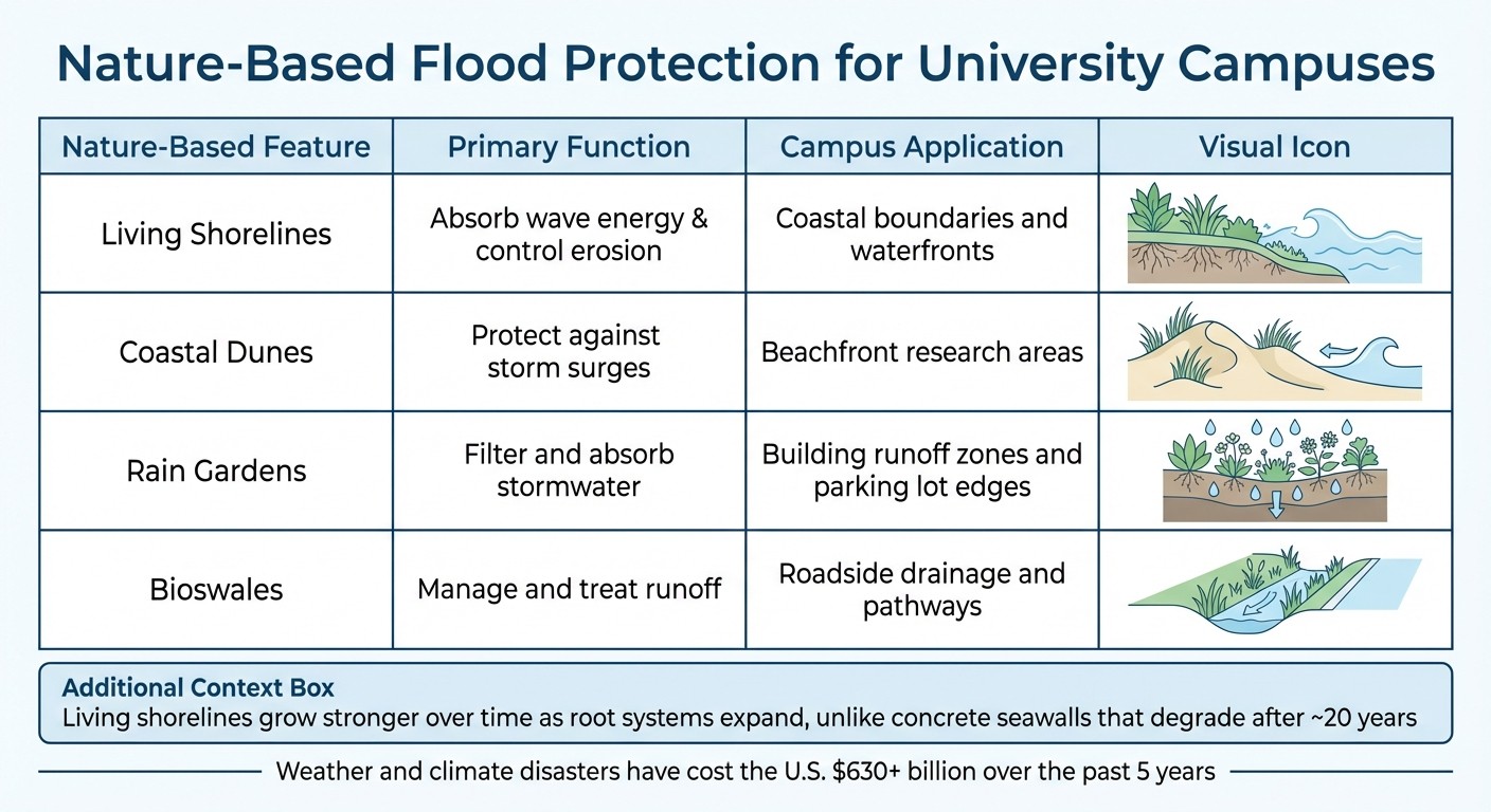
Key nature-based features and their campus uses include:
| Nature-Based Feature | Primary Function | Campus Application |
| --- | --- | --- |
| <strong>Living Shorelines</strong> | Absorb wave energy & control erosion | Coastal boundaries and waterfronts |
| <strong>Coastal Dunes</strong> | Protect against storm surges | Beachfront research areas |
| <strong>Rain Gardens</strong> | Filter and absorb stormwater | Building runoff zones and parking lot edges |
| <strong>Bioswales</strong> | Manage and treat runoff | Roadside drainage and pathways
The financial argument for nature-based solutions is strong. Over the past five years, weather and climate-related disasters have cost the U.S. more than $630 billion [9]. With 40% of the population living in coastal areas, these strategies are especially relevant for institutions in vulnerable regions. Unlike concrete seawalls that degrade after about 20 years, living shorelines grow stronger as root systems expand and ecosystems mature [10].
Combining Physical and Policy-Based Resilience Methods
Protecting a campus effectively requires a blend of physical infrastructure and strategic planning. While physical barriers protect vital assets against immediate threats, policy measures such as zoning changes and emergency protocols address long-term risks and improve response strategies. By merging these approaches, universities can establish comprehensive solutions that evolve alongside changing climate conditions. The combination of built defenses and policy-driven strategies lays a strong foundation for the detailed methods discussed below.
Physical Solutions: Building Flood Defenses
Hard infrastructure plays a key role in safeguarding critical campus assets during severe weather events. While engineered defenses offer immediate protection, their long-term success depends on careful planning. For instance, after Tropical Storm Allison, Rice University introduced specialized flood defenses, including submarine doors, manual "swing logs", and floodwalls around basement windows. These measures proved their worth during Hurricane Ike in 2008 when the campus remained dry and operational, even as surrounding areas experienced heavy flooding [1].
Physical defenses should focus on essential infrastructure such as biomedical labs, animal facilities, and underground utility systems. Hybrid green-gray systems, which combine natural vegetation with engineered structures, provide additional benefits. They can significantly reduce wave impacts, allowing for lower seawall heights and cutting construction costs. Research indicates that flooding behind a seawall is nearly eliminated when vegetation density and area exceed approximately 11,500 stems, regardless of wave strength or seawall height [6].
Policy Measures: Planning and Zoning Changes
Policy-driven strategies complement physical defenses by reducing risk exposure through thoughtful planning and regulatory measures. For example, the Massachusetts Institute of Technology (MIT) developed the "MIT Campus Flood Risk Model", a collaboration involving the MIT Office of Sustainability and the City of Cambridge. This model integrates campus-specific data with city-scale projections to guide decisions on construction and infrastructure renewal [2][3].
"MIT uses the City of Cambridge projections as a planning basis for campus resiliency and adaptation because these represent the best available, locally-scaled projections; align the campus with local regulatory resiliency planning standards; and enable effective planning across campus and City scales." - MIT Sustainability [3]
Additionally, floodplain management policies offer a cost-effective way to reduce risks for new infrastructure. Adopting National Flood Insurance Program (NFIP) standards and higher building practices ensures stronger protection. For example, regulations requiring that structures meet updated floodplain standards if repair costs exceed 50% of their market value help phase out older, vulnerable buildings over time [12].
Combining Physical and Policy Approaches
Integrating physical and policy-based measures creates stronger, more effective resilience strategies. The table below outlines how these approaches work together:
| Policy Measure | Physical Counterpart | Resilience Benefit |
| --- | --- | --- |
| <strong>Zoning/Building Standards</strong> | Elevated foundations & floodwalls | Keeps new buildings above projected surge levels <a href="https://fema.gov/case-study/mitigation-measures-protected-university-floods" target="_blank" style="text-decoration: none;" rel="nofollow noopener noreferrer" data-framer-link="Link:{"url":"https://fema.gov/case-study/mitigation-measures-protected-university-floods","type":"url"}" data-framer-open-in-new-tab=""><sup>[1]</sup></a><a href="https://www.fema.gov/floodplain-management/manage-risk" target="_blank" style="text-decoration: none;" rel="nofollow noopener noreferrer" data-framer-link="Link:{"url":"https://www.fema.gov/floodplain-management/manage-risk","type":"url"}" data-framer-open-in-new-tab=""><sup>[12]</sup></a> |
| <strong>Emergency Protocols</strong> | Flood alert systems & sensors | Provides time to deploy barriers like flood logs <a href="https://fema.gov/case-study/mitigation-measures-protected-university-floods" target="_blank" style="text-decoration: none;" rel="nofollow noopener noreferrer" data-framer-link="Link:{"url":"https://fema.gov/case-study/mitigation-measures-protected-university-floods","type":"url"}" data-framer-open-in-new-tab=""><sup>[1]</sup></a><a href="https://sustainability.mit.edu/climate-action/build-resilience/flood-risks" target="_blank" style="text-decoration: none;" rel="nofollow noopener noreferrer" data-framer-link="Link:{"url":"https://sustainability.mit.edu/climate-action/build-resilience/flood-risks","type":"url"}" data-framer-open-in-new-tab=""><sup>[3]</sup></a> |
| <strong>Floodplain Management</strong> | Underground barriers & submarine doors | Lowers insurance risks and protects critical utilities in basements <a href="https://fema.gov/case-study/mitigation-measures-protected-university-floods" target="_blank" style="text-decoration: none;" rel="nofollow noopener noreferrer" data-framer-link="Link:{"url":"https://fema.gov/case-study/mitigation-measures-protected-university-floods","type":"url"}" data-framer-open-in-new-tab=""><sup>[1]</sup></a><a href="https://www.fema.gov/floodplain-management/manage-risk" target="_blank" style="text-decoration: none;" rel="nofollow noopener noreferrer" data-framer-link="Link:{"url":"https://www.fema.gov/floodplain-management/manage-risk","type":"url"}" data-framer-open-in-new-tab=""><sup>[12]</sup></a> |
| <strong>Land-Use Planning</strong> | Green infrastructure & detention ponds | Manages water runoff and prevents city drainage systems from being overwhelmed <a href="https://fema.gov/case-study/mitigation-measures-protected-university-floods" target="_blank" style="text-decoration: none;" rel="nofollow noopener noreferrer" data-framer-link="Link:{"url":"https://fema.gov/case-study/mitigation-measures-protected-university-floods","type":"url"}" data-framer-open-in-new-tab=""><sup>[1]</sup></a><a href="https://sustainability.mit.edu/climate-action/build-resilience/flood-risks" target="_blank" style="text-decoration: none;" rel="nofollow noopener noreferrer" data-framer-link="Link:{"url":"https://sustainability.mit.edu/climate-action/build-resilience/flood-risks","type":"url"}" data-framer-open-in-new-tab=""><sup>[3]</sup></a> |
| Policy Measure | Physical Counterpart | Resilience Benefit |
| --- | --- | --- |
| <strong>Zoning/Building Standards</strong> | Elevated foundations & floodwalls | Keeps new buildings above projected surge levels <a href="https://fema.gov/case-study/mitigation-measures-protected-university-floods" target="_blank" style="text-decoration: none;" rel="nofollow noopener noreferrer" data-framer-link="Link:{"url":"https://fema.gov/case-study/mitigation-measures-protected-university-floods","type":"url"}" data-framer-open-in-new-tab=""><sup>[1]</sup></a><a href="https://www.fema.gov/floodplain-management/manage-risk" target="_blank" style="text-decoration: none;" rel="nofollow noopener noreferrer" data-framer-link="Link:{"url":"https://www.fema.gov/floodplain-management/manage-risk","type":"url"}" data-framer-open-in-new-tab=""><sup>[12]</sup></a> |
| <strong>Emergency Protocols</strong> | Flood alert systems & sensors | Provides time to deploy barriers like flood logs <a href="https://fema.gov/case-study/mitigation-measures-protected-university-floods" target="_blank" style="text-decoration: none;" rel="nofollow noopener noreferrer" data-framer-link="Link:{"url":"https://fema.gov/case-study/mitigation-measures-protected-university-floods","type":"url"}" data-framer-open-in-new-tab=""><sup>[1]</sup></a><a href="https://sustainability.mit.edu/climate-action/build-resilience/flood-risks" target="_blank" style="text-decoration: none;" rel="nofollow noopener noreferrer" data-framer-link="Link:{"url":"https://sustainability.mit.edu/climate-action/build-resilience/flood-risks","type":"url"}" data-framer-open-in-new-tab=""><sup>[3]</sup></a> |
| <strong>Floodplain Management</strong> | Underground barriers & submarine doors | Lowers insurance risks and protects critical utilities in basements <a href="https://fema.gov/case-study/mitigation-measures-protected-university-floods" target="_blank" style="text-decoration: none;" rel="nofollow noopener noreferrer" data-framer-link="Link:{"url":"https://fema.gov/case-study/mitigation-measures-protected-university-floods","type":"url"}" data-framer-open-in-new-tab=""><sup>[1]</sup></a><a href="https://www.fema.gov/floodplain-management/manage-risk" target="_blank" style="text-decoration: none;" rel="nofollow noopener noreferrer" data-framer-link="Link:{"url":"https://www.fema.gov/floodplain-management/manage-risk","type":"url"}" data-framer-open-in-new-tab=""><sup>[12]</sup></a> |
| <strong>Land-Use Planning</strong> | Green infrastructure & detention ponds | Manages water runoff and prevents city drainage systems from being overwhelmed <a href="https://fema.gov/case-study/mitigation-measures-protected-university-floods" target="_blank" style="text-decoration: none;" rel="nofollow noopener noreferrer" data-framer-link="Link:{"url":"https://fema.gov/case-study/mitigation-measures-protected-university-floods","type":"url"}" data-framer-open-in-new-tab=""><sup>[1]</sup></a><a href="https://sustainability.mit.edu/climate-action/build-resilience/flood-risks" target="_blank" style="text-decoration: none;" rel="nofollow noopener noreferrer" data-framer-link="Link:{"url":"https://sustainability.mit.edu/climate-action/build-resilience/flood-risks","type":"url"}" data-framer-open-in-new-tab=""><sup>[3]</sup></a> |This integrated approach allows campuses to serve as "test beds" for climate adaptation, turning scientific research into actionable plans for immediate and long-term resilience [2].
Working with Stakeholders to Build Resilience Solutions
Creating coastal resilience strategies demands input from both technical experts and community members. Students, faculty, local government bodies, and residents each provide valuable insights that enhance flood mitigation efforts. While technical risk assessments lay the groundwork, the success of resilience planning hinges on active collaboration with stakeholders. Universities that prioritize early engagement with these groups can craft solutions that meet genuine needs, build trust, and encourage shared responsibility. Research indicates that resilience plans are most effective when campus strategies align with local regulations [3] and incorporate a variety of perspectives [13].
Running Workshops and Scenario Planning Sessions
Tabletop exercises are a practical way to evaluate flood preparedness strategies before emergencies occur. Collaborative sessions involving university staff and city officials can uncover communication gaps and fine-tune emergency protocols [3]. These workshops also serve to simplify complex climate science, turning it into actionable guidance for campus managers [2][3].
Both immediate and long-term scenarios should be addressed during these sessions to inform infrastructure planning [7]. With roughly 18% of high flood-risk populations falling into "high social vulnerability" categories, targeted engagement is crucial. Adopting a "No Adverse Impact" approach ensures that campus mitigation efforts do not inadvertently increase flood risks for surrounding communities [7].
"The most successful campus resilience plans will be those that fully embrace the catalytic nature of resilience assessment and planning, and that incorporate diversity and inclusiveness throughout the process." - Second Nature [13]
Using Tools to Visualize Flood Risks
Visualization tools can transform dense climate data into accessible planning resources. Interactive dashboards, for example, allow users to explore flood risks through maps and graphics, making the information far more digestible than lengthy technical documents. These dashboards should illustrate multiple flood scenarios, such as 24-hour rain events, short-term flash floods, watershed drainage patterns, and the combined effects of storm surges and sea level rise. They should also account for local factors like land subsidence, which can exacerbate sea level rise [3][7].
The financial argument for addressing flood risks is clear. Studies show that the cost of inaction can be 4 to 10 times higher than proactive investments in hazard mitigation. For instance, allocating $50 billion toward adaptation strategies over the next two decades could prevent approximately $135 billion in losses over the lifespan of those measures [7].
Working with Experts for Data-Driven Planning
Technical expertise is essential for turning plans into action. Council Fire collaborates with campuses to advance climate resilience by combining stakeholder engagement with data-driven strategies. Their methods use systems thinking and strategic communication to translate ambitious goals into measurable outcomes across areas like infrastructure, natural resource management, and community well-being.
Collaboration among researchers, climate scientists, engineers, and local government officials ensures that resilience plans address key areas, including ecosystem services, infrastructure, equity, governance, health, and economic impacts [3][13]. Forming dedicated Resilience Planning Working Groups can foster continuous cooperation between university teams and their surrounding communities [13].
"Resilience is not just about survival and bouncing back from disruptions; it is about being able to thrive." - Second Nature [13]
Regional partnerships can further amplify campus efforts. By working closely with state agencies and neighboring municipalities, universities can contribute to broader strategies that reduce flood risks across entire regions. This approach ensures that campus and community resilience initiatives are not only aligned but also mutually reinforcing [3]. Such collaboration lays the groundwork for comprehensive, community-focused resilience planning.
Conclusion: Building Long-Term Coastal Resilience for Universities
Universities are increasingly vulnerable to rising sea levels and more intense rainstorms, posing significant flood risks that demand urgent attention and forward-thinking strategies [3]. Leading institutions are already paving the way with innovative approaches to safeguard their campuses.
A strong example of a data-driven strategy comes from MIT, which routinely updates campus-wide flood models and incorporates climate projections into all new construction projects [2][3]. By transforming complex climate data into practical measures, MIT ensures the protection of critical infrastructure and high-value research facilities, demonstrating the power of proactive planning.
Economic foresight has also proven essential. Rice University’s $2.75 million investment in flood mitigation measures between 2002 and 2003, with substantial support from FEMA, highlights the importance of timely action. These upgrades paid off during Hurricane Ike, enabling the campus to remain operational [1]. Doug Tomlinson, Assistant Vice President in Rice University’s Project Management and Engineering Department, noted:
"The FEMA money helped us tremendously to get our drainage up to date and it works like it is designed to do. This campus drains a lot better than it did in the past." [1]
Looking ahead, universities must turn risk assessments and nature-based solutions into actionable, long-term plans. This includes aligning campus development with local standards and climate projections, conducting building porosity assessments to pinpoint vulnerabilities, and embedding flood risk modeling into capital renewal projects. Collaboration with state agencies and neighboring municipalities is equally vital. For instance, while MIT benefits from the Charles River Dam, its effectiveness relies on the coordinated efforts of 14 municipalities [3]. Campuses can also act as testing grounds, bringing researchers and experts together to create cost-effective, site-specific solutions.
The time to act is now. Investing in comprehensive resilience planning today will help avoid far greater costs in the future, ensuring the protection of campus infrastructure, research, and community well-being. Bold steps taken now will secure a more resilient future for universities.
FAQs
What are the best nature-based strategies to manage flooding on university campuses?
Nature-based strategies incorporate natural elements to address flooding challenges while delivering additional environmental and social advantages. Examples of green infrastructure include wetlands, bioswales, green roofs, permeable pavements, and stream restoration. These features are designed to absorb and slow stormwater runoff, helping to lower the risk of surface flooding during intense rainfall.
For coastal campuses, methods such as natural shoreline stabilization, dune restoration, and wetland restoration can guard against storm surges and erosion. Beyond their practicality, these solutions contribute to better water quality, support wildlife habitats, and reduce urban heat effects. By weaving these strategies into campus planning, universities can strengthen their defenses against climate-related risks while promoting ecological health and community benefits.
How can universities assess and plan for coastal flood risks effectively?
Universities can take proactive steps to address coastal flood risks by leveraging localized climate projections and conducting thorough flood risk assessments. These tools are essential for identifying vulnerabilities, such as how rising sea levels or more frequent extreme weather events might affect campus infrastructure. For instance, downscaled climate models and geographic information systems (GIS) allow institutions to visualize potential flood scenarios and highlight areas most at risk.
Resources like FEMA's flood mapping guidance and NOAA's sea level rise models offer critical data to enhance the accuracy of these assessments. By integrating these tools with input from stakeholders and findings from ongoing research, universities can craft strategies tailored to their specific geographic and structural needs. This approach not only helps safeguard campuses but also supports long-term resilience against evolving climate challenges.
Why is it important to collaborate with stakeholders when creating campus resilience plans?
Collaborating with stakeholders is a key step in crafting effective campus resilience plans. It brings together a range of perspectives, expertise, and resources, which is crucial for addressing complex challenges. By including university leaders, local governments, community members, and environmental experts, institutions can develop strategies that align with local conditions, meet regulatory standards, and address community priorities. This approach ensures resilience efforts are both actionable and meaningful.
Involving stakeholders also fosters a sense of shared responsibility, which is vital for the long-term success of these initiatives. Collaborative efforts enable thorough risk assessments and the creation of adaptable infrastructure capable of handling climate-related challenges like flooding or rising sea levels. Beyond strengthening campuses, this approach also builds deeper connections with the surrounding community, creating safer and more sustainable environments for everyone.
Related Blog Posts
How to Build a Climate Resilience Plan for Universities & Research Institutions
How to Integrate Climate Risk into Infrastructure Planning for Universities & Research Institutions
How to Design Coastal Resilience & Flood Mitigation for Municipalities & Government Agencies
How to Design Coastal Resilience & Flood Mitigation for NGOs & Nonprofits
Latest Articles
©2025


FAQ
01
What does it really mean to “redefine profit”?
02
What makes Council Fire different?
03
Who does Council Fire you work with?
04
What does working with Council Fire actually look like?
05
How does Council Fire help organizations turn big goals into action?
06
How does Council Fire define and measure success?
Jan 29, 2026
How to Design Coastal Resilience & Flood Mitigation for Universities & Research Institutions
Sustainability Strategy
In This Article
Practical guidance on assessing coastal flood risks, using nature-based defenses and engineered solutions, and aligning campus policy and stakeholders for long-term protection.
How to Design Coastal Resilience & Flood Mitigation for Universities & Research Institutions
Universities near coastlines face growing risks from rising sea levels and extreme weather. Flooding can damage critical infrastructure, disrupt operations, and jeopardize research. To address these challenges, campuses must adopt specialized strategies that combine advanced modeling, tailored infrastructure, and nature-based solutions. Key measures include:
Assessing Risks: Use tools like hydrodynamic models and hazard mapping to identify vulnerable areas, such as underground utilities and basements.
Targeted Infrastructure: Install floodwalls, submarine doors, and improved drainage systems to protect high-risk facilities.
Nature-Based Solutions: Implement living shorelines, rain gardens, and bioswales to manage stormwater and reduce wave energy.
Future Planning: Incorporate localized climate projections to guide construction and upgrades, ensuring long-term protection.
Stakeholder Collaboration: Work with local governments, students, and experts to align campus efforts with regional resilience goals.
Proactive investment in these strategies can save universities from future repair costs, protect academic resources, and maintain operational continuity during climate-related events.
How to Assess Coastal Flood Risks on Campus
Using Hazard Mapping and Modeling Tools
Universities need reliable tools to model how flooding might impact their campuses. By combining various technologies, they can create a comprehensive understanding of potential risks.
Hydrodynamic models like XBeach simulate how waves move across campus grounds, overtop barriers, and flood specific areas [6]. Similarly, the Advanced CIRCulation (ADCIRC) model predicts storm surge patterns and tidal impacts. While these models require significant computational resources, surrogate models - using methods like Gene Expression Programming - allow for quicker testing of thousands of scenarios [6].
The U.S. Geological Survey provides the Coastal Change Hazards Portal, which organizes data into three main categories: present-day storm scenarios that show dune erosion and inundation, historical shoreline change patterns, and assessments of vulnerability to sea-level rise [4][5]. This portal uses the Coastal Vulnerability Index (CVI) to assess risk factors such as tidal range, wave height, and coastal slope.
For tailored campus planning, universities should downscale global climate models to create localized projections that align with municipal regulations [3][2]. These projections make broad climate data actionable for campus planners. Universities can develop dynamic two-dimensional models that incorporate campus-specific details - like new building projects and underground utilities - into city-scale flood risk assessments. This approach ensures that risks from precipitation, river flooding, and sea-level rise are examined holistically [3]. With these advanced tools highlighting flood patterns, the next step involves identifying vulnerable campus infrastructure.
Identifying Physical and Operational Weak Points
Physical inspections and on-ground assessments complement modeling efforts, helping to create a complete risk profile. Once the modeling tools are in place, the focus shifts to identifying specific vulnerabilities on campus. This requires both advanced analysis and careful physical evaluations.
One effective method is what MIT refers to as a "Building Porosity Hunt" - a detailed inspection of campus structures to locate areas where water might enter during floods [3]. This includes examining basement windows, utility access points, loading docks, and other openings below potential flood levels. Special attention should be given to underground utility systems, as flooding in these areas can disrupt power, heating, and cooling across multiple buildings.
The assessment should also evaluate whether existing drainage and stormwater systems can handle intense "cloud burst" rainfall (lasting 1–3 hours) as well as prolonged 24-hour rain events [3]. Many campuses discover that their infrastructure was designed for outdated weather patterns and cannot handle current or future conditions. Critical facilities like labs, libraries, and power systems often require immediate protection because they house vital research, equipment, and services.
Using the Coastal Vulnerability Index provides a structured way to quantify risks based on physical factors such as slope and geomorphology, while also considering the campus's natural adaptability [4]. This helps prioritize areas needing immediate attention versus those that can be addressed in the long term. These physical assessments are essential for integrating future climate projections into campus planning.
Using Future Climate Projections in Planning
Relying solely on historical flood data is no longer sufficient. Climate change is altering the frequency and intensity of flooding, making forward-looking projections critical for effective campus planning.
Projections show that extreme rainfall events are becoming more frequent. Coastal defenses, such as the Charles River Dam protecting MIT's campus, were not designed to account for rising sea levels and may face overtopping risks within the next 20 to 30 years [3].
It’s important to evaluate risks over multiple timeframes - such as 2030, 2050, and 2100 - to align with the varying lifespans of campus assets [7]. For example, a building constructed today may still be in use when sea levels are 4 feet higher than they are now. These projections should also factor in local subsidence (land sinking), which can accelerate the rate of relative sea-level rise in certain areas [7].
The financial argument for using these projections is clear. Investing in adaptation now is far cheaper than dealing with future flood damage. Studies estimate that the cost of inaction can be 4 to 10 times higher than the cost of implementing hazard mitigation measures [7]. To stay ahead of these changes, universities should update their campus flood risk models at least every three years. This ensures that planning reflects new construction, updated environmental data, and the latest climate science [3]. Regular updates keep strategies relevant as both the campus and environmental conditions evolve.
W3 Seminar - Coastal resilience by design: Nature-based solutions across scales
Designing Nature-Based Flood Protection Systems
Nature-Based Flood Protection Features for University Campuses
Nature-based solutions safeguard campuses by reducing wave energy, improving stormwater management, and supporting ecosystems that align with infrastructure and educational goals.
Installing Living Shorelines and Coastal Dunes
Living shorelines offer a natural alternative to traditional concrete seawalls, using materials like native plants, sand, rocks, and oyster shells to absorb and dissipate wave energy. Unlike hard barriers that reflect waves and exacerbate erosion, these systems work with the environment [10].
In August 2024, Eckerd College in St. Petersburg, Florida, completed a 200-foot living shoreline to replace an aging seawall. Led by Associate Professor Jesse Sherry and supported by over 80 student volunteers, the project included a gradual slope with seagrasses and muhly grass on one side and a terraced design with rocks and mangroves on the other. Funding came from a $150,000 grant from the Tampa Bay Estuary Program in 2021 and $350,000 in state grants in 2023. The design also incorporated stormwater drainage, routing runoff through the newly planted vegetation [10].
Choosing the right design requires site-specific analysis, considering factors such as erosion rates, wave energy, wind patterns, and soil type [11]. For limited spaces, terraced designs with rocks and mangroves are effective, while gradual slopes work best in larger areas. Mangroves are especially beneficial as they can build land over time, helping to address sea-level rise. Biodegradable materials are recommended to stabilize plantings until they take root [10].
Coastal dunes provide another layer of protection for beachfront facilities. For example, the U.S. Army Corps of Engineers restored Swan Island in Chesapeake Bay to protect Ewell, Maryland. This project used 60,000 cubic yards of dredged sediments and native dune plants to absorb wave energy and prevent further erosion [9].
Using Green Infrastructure for Stormwater Management
Rain gardens and bioswales help manage stormwater at its source, reducing the strain on traditional drainage systems. These features filter runoff, allowing water to seep into the ground rather than overwhelming storm drains during heavy rains.
In July 2023, the University of Texas at Arlington (UTA) released a Green Infrastructure Report after collaborating with the U.S. Environmental Protection Agency in 2022. Through a design workshop, students and faculty developed strategies to handle intense rainstorms and heat stress on campus. The resulting framework included a prioritization matrix for green infrastructure projects, considering factors like watershed location, ecological benefits, cost, and community impact. This ensured new investments aligned with the university's sustainability goals [8].
Rain gardens and bioswales are particularly effective around parking lots, building perimeters, roads, and pathways. These systems slow water flow, allowing sediments and pollutants to settle before entering larger water systems. Natural features like salt marshes also help by absorbing rainwater, reducing flooding, and improving water quality [9].
Universities can participate in the EPA's "Campus RainWorks Challenge", which supports green infrastructure design and provides technical assistance for implementation [8].
These approaches not only protect campuses but also create opportunities for research and teaching, fostering resilience through education.
Examples of Nature-Based Solutions at Universities
Practical examples highlight how campuses integrate resilience projects with academic goals.
At Eckerd College, students participated directly in constructing the living shoreline [10]. Meanwhile, UTA developed a green infrastructure framework that set clear criteria for prioritizing future investments, fostering collaboration among campus stakeholders [8]. By treating campuses as "living laboratories", universities can align flood protection efforts with research and teaching, creating dual-purpose projects.
Key nature-based features and their campus uses include:
| Nature-Based Feature | Primary Function | Campus Application |
| --- | --- | --- |
| <strong>Living Shorelines</strong> | Absorb wave energy & control erosion | Coastal boundaries and waterfronts |
| <strong>Coastal Dunes</strong> | Protect against storm surges | Beachfront research areas |
| <strong>Rain Gardens</strong> | Filter and absorb stormwater | Building runoff zones and parking lot edges |
| <strong>Bioswales</strong> | Manage and treat runoff | Roadside drainage and pathways
The financial argument for nature-based solutions is strong. Over the past five years, weather and climate-related disasters have cost the U.S. more than $630 billion [9]. With 40% of the population living in coastal areas, these strategies are especially relevant for institutions in vulnerable regions. Unlike concrete seawalls that degrade after about 20 years, living shorelines grow stronger as root systems expand and ecosystems mature [10].
Combining Physical and Policy-Based Resilience Methods
Protecting a campus effectively requires a blend of physical infrastructure and strategic planning. While physical barriers protect vital assets against immediate threats, policy measures such as zoning changes and emergency protocols address long-term risks and improve response strategies. By merging these approaches, universities can establish comprehensive solutions that evolve alongside changing climate conditions. The combination of built defenses and policy-driven strategies lays a strong foundation for the detailed methods discussed below.
Physical Solutions: Building Flood Defenses
Hard infrastructure plays a key role in safeguarding critical campus assets during severe weather events. While engineered defenses offer immediate protection, their long-term success depends on careful planning. For instance, after Tropical Storm Allison, Rice University introduced specialized flood defenses, including submarine doors, manual "swing logs", and floodwalls around basement windows. These measures proved their worth during Hurricane Ike in 2008 when the campus remained dry and operational, even as surrounding areas experienced heavy flooding [1].
Physical defenses should focus on essential infrastructure such as biomedical labs, animal facilities, and underground utility systems. Hybrid green-gray systems, which combine natural vegetation with engineered structures, provide additional benefits. They can significantly reduce wave impacts, allowing for lower seawall heights and cutting construction costs. Research indicates that flooding behind a seawall is nearly eliminated when vegetation density and area exceed approximately 11,500 stems, regardless of wave strength or seawall height [6].
Policy Measures: Planning and Zoning Changes
Policy-driven strategies complement physical defenses by reducing risk exposure through thoughtful planning and regulatory measures. For example, the Massachusetts Institute of Technology (MIT) developed the "MIT Campus Flood Risk Model", a collaboration involving the MIT Office of Sustainability and the City of Cambridge. This model integrates campus-specific data with city-scale projections to guide decisions on construction and infrastructure renewal [2][3].
"MIT uses the City of Cambridge projections as a planning basis for campus resiliency and adaptation because these represent the best available, locally-scaled projections; align the campus with local regulatory resiliency planning standards; and enable effective planning across campus and City scales." - MIT Sustainability [3]
Additionally, floodplain management policies offer a cost-effective way to reduce risks for new infrastructure. Adopting National Flood Insurance Program (NFIP) standards and higher building practices ensures stronger protection. For example, regulations requiring that structures meet updated floodplain standards if repair costs exceed 50% of their market value help phase out older, vulnerable buildings over time [12].
Combining Physical and Policy Approaches
Integrating physical and policy-based measures creates stronger, more effective resilience strategies. The table below outlines how these approaches work together:
| Policy Measure | Physical Counterpart | Resilience Benefit |
| --- | --- | --- |
| <strong>Zoning/Building Standards</strong> | Elevated foundations & floodwalls | Keeps new buildings above projected surge levels <a href="https://fema.gov/case-study/mitigation-measures-protected-university-floods" target="_blank" style="text-decoration: none;" rel="nofollow noopener noreferrer" data-framer-link="Link:{"url":"https://fema.gov/case-study/mitigation-measures-protected-university-floods","type":"url"}" data-framer-open-in-new-tab=""><sup>[1]</sup></a><a href="https://www.fema.gov/floodplain-management/manage-risk" target="_blank" style="text-decoration: none;" rel="nofollow noopener noreferrer" data-framer-link="Link:{"url":"https://www.fema.gov/floodplain-management/manage-risk","type":"url"}" data-framer-open-in-new-tab=""><sup>[12]</sup></a> |
| <strong>Emergency Protocols</strong> | Flood alert systems & sensors | Provides time to deploy barriers like flood logs <a href="https://fema.gov/case-study/mitigation-measures-protected-university-floods" target="_blank" style="text-decoration: none;" rel="nofollow noopener noreferrer" data-framer-link="Link:{"url":"https://fema.gov/case-study/mitigation-measures-protected-university-floods","type":"url"}" data-framer-open-in-new-tab=""><sup>[1]</sup></a><a href="https://sustainability.mit.edu/climate-action/build-resilience/flood-risks" target="_blank" style="text-decoration: none;" rel="nofollow noopener noreferrer" data-framer-link="Link:{"url":"https://sustainability.mit.edu/climate-action/build-resilience/flood-risks","type":"url"}" data-framer-open-in-new-tab=""><sup>[3]</sup></a> |
| <strong>Floodplain Management</strong> | Underground barriers & submarine doors | Lowers insurance risks and protects critical utilities in basements <a href="https://fema.gov/case-study/mitigation-measures-protected-university-floods" target="_blank" style="text-decoration: none;" rel="nofollow noopener noreferrer" data-framer-link="Link:{"url":"https://fema.gov/case-study/mitigation-measures-protected-university-floods","type":"url"}" data-framer-open-in-new-tab=""><sup>[1]</sup></a><a href="https://www.fema.gov/floodplain-management/manage-risk" target="_blank" style="text-decoration: none;" rel="nofollow noopener noreferrer" data-framer-link="Link:{"url":"https://www.fema.gov/floodplain-management/manage-risk","type":"url"}" data-framer-open-in-new-tab=""><sup>[12]</sup></a> |
| <strong>Land-Use Planning</strong> | Green infrastructure & detention ponds | Manages water runoff and prevents city drainage systems from being overwhelmed <a href="https://fema.gov/case-study/mitigation-measures-protected-university-floods" target="_blank" style="text-decoration: none;" rel="nofollow noopener noreferrer" data-framer-link="Link:{"url":"https://fema.gov/case-study/mitigation-measures-protected-university-floods","type":"url"}" data-framer-open-in-new-tab=""><sup>[1]</sup></a><a href="https://sustainability.mit.edu/climate-action/build-resilience/flood-risks" target="_blank" style="text-decoration: none;" rel="nofollow noopener noreferrer" data-framer-link="Link:{"url":"https://sustainability.mit.edu/climate-action/build-resilience/flood-risks","type":"url"}" data-framer-open-in-new-tab=""><sup>[3]</sup></a> |
This integrated approach allows campuses to serve as "test beds" for climate adaptation, turning scientific research into actionable plans for immediate and long-term resilience [2].
Working with Stakeholders to Build Resilience Solutions
Creating coastal resilience strategies demands input from both technical experts and community members. Students, faculty, local government bodies, and residents each provide valuable insights that enhance flood mitigation efforts. While technical risk assessments lay the groundwork, the success of resilience planning hinges on active collaboration with stakeholders. Universities that prioritize early engagement with these groups can craft solutions that meet genuine needs, build trust, and encourage shared responsibility. Research indicates that resilience plans are most effective when campus strategies align with local regulations [3] and incorporate a variety of perspectives [13].
Running Workshops and Scenario Planning Sessions
Tabletop exercises are a practical way to evaluate flood preparedness strategies before emergencies occur. Collaborative sessions involving university staff and city officials can uncover communication gaps and fine-tune emergency protocols [3]. These workshops also serve to simplify complex climate science, turning it into actionable guidance for campus managers [2][3].
Both immediate and long-term scenarios should be addressed during these sessions to inform infrastructure planning [7]. With roughly 18% of high flood-risk populations falling into "high social vulnerability" categories, targeted engagement is crucial. Adopting a "No Adverse Impact" approach ensures that campus mitigation efforts do not inadvertently increase flood risks for surrounding communities [7].
"The most successful campus resilience plans will be those that fully embrace the catalytic nature of resilience assessment and planning, and that incorporate diversity and inclusiveness throughout the process." - Second Nature [13]
Using Tools to Visualize Flood Risks
Visualization tools can transform dense climate data into accessible planning resources. Interactive dashboards, for example, allow users to explore flood risks through maps and graphics, making the information far more digestible than lengthy technical documents. These dashboards should illustrate multiple flood scenarios, such as 24-hour rain events, short-term flash floods, watershed drainage patterns, and the combined effects of storm surges and sea level rise. They should also account for local factors like land subsidence, which can exacerbate sea level rise [3][7].
The financial argument for addressing flood risks is clear. Studies show that the cost of inaction can be 4 to 10 times higher than proactive investments in hazard mitigation. For instance, allocating $50 billion toward adaptation strategies over the next two decades could prevent approximately $135 billion in losses over the lifespan of those measures [7].
Working with Experts for Data-Driven Planning
Technical expertise is essential for turning plans into action. Council Fire collaborates with campuses to advance climate resilience by combining stakeholder engagement with data-driven strategies. Their methods use systems thinking and strategic communication to translate ambitious goals into measurable outcomes across areas like infrastructure, natural resource management, and community well-being.
Collaboration among researchers, climate scientists, engineers, and local government officials ensures that resilience plans address key areas, including ecosystem services, infrastructure, equity, governance, health, and economic impacts [3][13]. Forming dedicated Resilience Planning Working Groups can foster continuous cooperation between university teams and their surrounding communities [13].
"Resilience is not just about survival and bouncing back from disruptions; it is about being able to thrive." - Second Nature [13]
Regional partnerships can further amplify campus efforts. By working closely with state agencies and neighboring municipalities, universities can contribute to broader strategies that reduce flood risks across entire regions. This approach ensures that campus and community resilience initiatives are not only aligned but also mutually reinforcing [3]. Such collaboration lays the groundwork for comprehensive, community-focused resilience planning.
Conclusion: Building Long-Term Coastal Resilience for Universities
Universities are increasingly vulnerable to rising sea levels and more intense rainstorms, posing significant flood risks that demand urgent attention and forward-thinking strategies [3]. Leading institutions are already paving the way with innovative approaches to safeguard their campuses.
A strong example of a data-driven strategy comes from MIT, which routinely updates campus-wide flood models and incorporates climate projections into all new construction projects [2][3]. By transforming complex climate data into practical measures, MIT ensures the protection of critical infrastructure and high-value research facilities, demonstrating the power of proactive planning.
Economic foresight has also proven essential. Rice University’s $2.75 million investment in flood mitigation measures between 2002 and 2003, with substantial support from FEMA, highlights the importance of timely action. These upgrades paid off during Hurricane Ike, enabling the campus to remain operational [1]. Doug Tomlinson, Assistant Vice President in Rice University’s Project Management and Engineering Department, noted:
"The FEMA money helped us tremendously to get our drainage up to date and it works like it is designed to do. This campus drains a lot better than it did in the past." [1]
Looking ahead, universities must turn risk assessments and nature-based solutions into actionable, long-term plans. This includes aligning campus development with local standards and climate projections, conducting building porosity assessments to pinpoint vulnerabilities, and embedding flood risk modeling into capital renewal projects. Collaboration with state agencies and neighboring municipalities is equally vital. For instance, while MIT benefits from the Charles River Dam, its effectiveness relies on the coordinated efforts of 14 municipalities [3]. Campuses can also act as testing grounds, bringing researchers and experts together to create cost-effective, site-specific solutions.
The time to act is now. Investing in comprehensive resilience planning today will help avoid far greater costs in the future, ensuring the protection of campus infrastructure, research, and community well-being. Bold steps taken now will secure a more resilient future for universities.
FAQs
What are the best nature-based strategies to manage flooding on university campuses?
Nature-based strategies incorporate natural elements to address flooding challenges while delivering additional environmental and social advantages. Examples of green infrastructure include wetlands, bioswales, green roofs, permeable pavements, and stream restoration. These features are designed to absorb and slow stormwater runoff, helping to lower the risk of surface flooding during intense rainfall.
For coastal campuses, methods such as natural shoreline stabilization, dune restoration, and wetland restoration can guard against storm surges and erosion. Beyond their practicality, these solutions contribute to better water quality, support wildlife habitats, and reduce urban heat effects. By weaving these strategies into campus planning, universities can strengthen their defenses against climate-related risks while promoting ecological health and community benefits.
How can universities assess and plan for coastal flood risks effectively?
Universities can take proactive steps to address coastal flood risks by leveraging localized climate projections and conducting thorough flood risk assessments. These tools are essential for identifying vulnerabilities, such as how rising sea levels or more frequent extreme weather events might affect campus infrastructure. For instance, downscaled climate models and geographic information systems (GIS) allow institutions to visualize potential flood scenarios and highlight areas most at risk.
Resources like FEMA's flood mapping guidance and NOAA's sea level rise models offer critical data to enhance the accuracy of these assessments. By integrating these tools with input from stakeholders and findings from ongoing research, universities can craft strategies tailored to their specific geographic and structural needs. This approach not only helps safeguard campuses but also supports long-term resilience against evolving climate challenges.
Why is it important to collaborate with stakeholders when creating campus resilience plans?
Collaborating with stakeholders is a key step in crafting effective campus resilience plans. It brings together a range of perspectives, expertise, and resources, which is crucial for addressing complex challenges. By including university leaders, local governments, community members, and environmental experts, institutions can develop strategies that align with local conditions, meet regulatory standards, and address community priorities. This approach ensures resilience efforts are both actionable and meaningful.
Involving stakeholders also fosters a sense of shared responsibility, which is vital for the long-term success of these initiatives. Collaborative efforts enable thorough risk assessments and the creation of adaptable infrastructure capable of handling climate-related challenges like flooding or rising sea levels. Beyond strengthening campuses, this approach also builds deeper connections with the surrounding community, creating safer and more sustainable environments for everyone.
Related Blog Posts
How to Build a Climate Resilience Plan for Universities & Research Institutions
How to Integrate Climate Risk into Infrastructure Planning for Universities & Research Institutions
How to Design Coastal Resilience & Flood Mitigation for Municipalities & Government Agencies
How to Design Coastal Resilience & Flood Mitigation for NGOs & Nonprofits
FAQ
What does it really mean to “redefine profit”?
What makes Council Fire different?
Who does Council Fire you work with?
What does working with Council Fire actually look like?
How does Council Fire help organizations turn big goals into action?
How does Council Fire define and measure success?