
Jan 27, 2026
How to Design Coastal Resilience & Flood Mitigation for Municipalities & Government Agencies
Sustainability Strategy
In This Article
Practical guidance for municipalities to assess coastal flood risks, update policies, combine engineering and nature-based defenses, engage communities, and secure funding.
How to Design Coastal Resilience & Flood Mitigation for Municipalities & Government Agencies
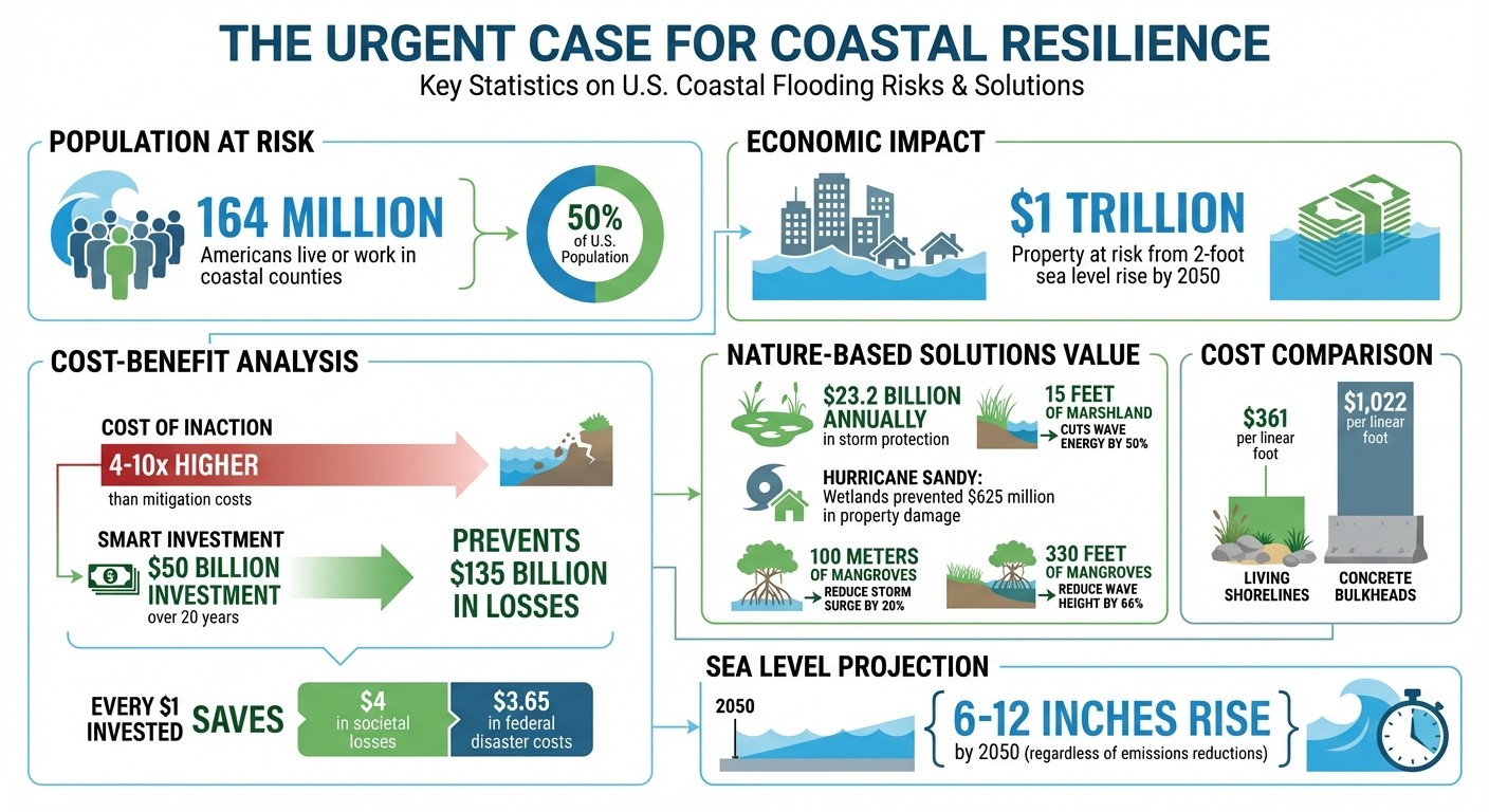
Coastal resilience and flood mitigation are critical as rising sea levels and extreme weather events put millions at risk. With over 164 million Americans living in coastal areas and $1 trillion in property potentially underwater by 2050, municipalities and government agencies must act now to protect lives, infrastructure, and economies. Here’s how:
Assess Risks: Use tools like NOAA’s Sea Level Calculator and Coastal Vulnerability Index to identify high-risk areas and critical infrastructure.
Plan Policies: Update zoning laws, building codes, and land use standards to reduce future risks. Align local plans with federal programs for funding.
Implement Solutions: Combine engineering defenses like seawalls with nature-based approaches such as wetlands and mangroves to reduce flooding.
Engage Communities: Include residents, especially vulnerable groups, in planning and decision-making to ensure equitable solutions.
Secure Funding: Leverage grants from FEMA, NOAA, and other federal programs to finance projects. Track results to measure impact and refine strategies.
Coastal Flooding Statistics and Economic Impact in the United States
New Guides to Support the Uptake of NBS to Reduce Flood Risks in Coastal Communities
Assessing Coastal Vulnerabilities and Risks
Conducting a thorough risk assessment is a crucial step in developing effective strategies to enhance coastal resilience. By pinpointing areas under the greatest threat and analyzing evolving risks, stakeholders can prioritize investments and implement protection measures that address the most pressing challenges. This groundwork supports strategic policy decisions and engineering solutions tailored to specific needs.
Using Data-Driven Risk Assessment Tools
A variety of advanced tools are available to assess coastal vulnerabilities with precision. NOAA's Sea Level Calculator offers insights by comparing historical flood data with future projections, highlighting the increasing frequency and severity of flooding as sea levels rise [3]. The Coastal Vulnerability Index (CVI) evaluates relative risk by analyzing six key factors: tidal range, wave height, coastal slope, shoreline changes, geomorphology, and historical rates of sea level rise [2].
For more detailed analysis, NOAA's Digital Coast Platform provides resources like Lidar, elevation data, and high-resolution land cover maps. These tools help identify vulnerable areas and critical infrastructure, including businesses and jobs located in coastal inundation zones prone to hurricane storm surges or tsunamis [3]. Additionally, the Coastal Change Hazards Portal supplies science-backed data on storm scenarios, shoreline change rates, and sea level rise vulnerabilities [2].
Local data plays a significant role as well. For example, accounting for land subsidence - where the ground sinks - can reveal heightened flooding risks in specific areas [1]. To stay informed and share knowledge, professionals can join the Coastal Inundation Community of Practice, which facilitates peer-to-peer learning and provides updates on the latest science and solutions for managing flooding risks [3]. Together, these tools and resources create a comprehensive risk profile to guide planning and decision-making.
Identifying High-Risk Infrastructure and Communities
Coastal risks are not evenly distributed, and neither are the resources to address them. A key starting point is identifying and prioritizing critical lifelines - essential infrastructure such as water supply systems, energy grids, evacuation routes, and wastewater treatment facilities [1]. These systems are often immovable and include assets like gas and oil facilities, thermal power plants, and bridges [1].
Beyond infrastructure, it’s vital to consider social vulnerability. Many vulnerable populations live in areas adjacent to shorefront properties and face socioeconomic barriers that limit their ability to adapt. The U.S. Climate Resilience Toolkit underscores this issue:
"Socioeconomic disparities create uneven exposures and sensitivities to growing coastal risks and limit adaptation options for some communities." [1]
Economic assets also warrant attention. Ports, tourist attractions, and fishing sites are critical drivers of both local and national economies and must be mapped and safeguarded [1]. Following the "No Adverse Impact" (NAI) principle, as recommended by the Association of State Floodplain Managers, ensures that new infrastructure projects do not inadvertently increase flood risks for surrounding properties [1]. Moreover, assessing impacts over extended timeframes - often spanning 100 years and using 2100 as a benchmark for long-term decisions - helps prepare for future challenges [1].
Developing Policy and Planning Frameworks
Building coastal resilience requires strong policy frameworks capable of guiding decisions for decades. Municipalities and government agencies must craft strategies that integrate land use planning, building standards, and infrastructure development, all while addressing immediate threats and preparing for long-term changes. With over $1 trillion in U.S. property and structures at risk of flooding from a sea level rise of two feet - potentially occurring as soon as 2050 - the need for immediate policy action is pressing [1].
The economic argument for proactive planning is clear. Research indicates that the costs of ignoring coastal hazards can be 4 to 10 times higher than the cost of implementing hazard mitigation measures. For instance, a $50 billion investment over 20 years could prevent $135 billion in losses [1].
Creating Resilience Plans
Developing an effective resilience plan begins with defining a planning horizon, such as 100 years (e.g., until 2100), and evaluating local sea level trends and land subsidence [1]. By considering multiple timeframes, communities can balance short-term projects with long-term investments.
The "No Adverse Impact" principle is a valuable tool for updating land use, zoning, and building standards. This approach ensures that new developments do not worsen flood risks and encourages policies that reflect both current and projected flood data [1].
Updating building codes is one of the most direct ways to improve resilience. Municipalities can raise freeboard requirements - extra elevation above base flood levels - for new structures and major renovations in high-risk areas. Similarly, zoning changes can limit development in zones prone to significant flooding, steering growth toward safer regions.
Policies must also address social vulnerabilities. Targeted assistance, such as subsidized elevation programs or relocation support, can protect at-risk communities. Decision-makers should prioritize "win-win" initiatives that offer multiple benefits. For example, ecosystem restoration not only enhances natural flood defenses but also creates jobs with wages exceeding the national average, providing economic opportunities for low-income coastal residents [1]. Transparent communication throughout the planning process, supported by accessible data and clear protocols, fosters public trust and helps stakeholders understand the rationale behind policy decisions.
Local strategies gain strength when aligned with broader state and federal guidelines, enabling access to critical resources and funding.
Aligning with Federal and State Guidelines
Once local resilience plans are defined, municipalities can enhance their efforts by tapping into federal and state frameworks. Federal agencies offer essential tools and funding opportunities to support local initiatives. For example, FEMA’s Flood Map Service Center provides detailed flood hazard data to guide zoning and building code updates, while NOAA’s Sea Level Rise Viewer helps communities visualize future flooding scenarios.
Aligning with federal guidelines unlocks substantial funding sources. Programs like FEMA’s Hazard Mitigation Grant Program and the Building Resilient Infrastructure and Communities (BRIC) initiative offer competitive grants for pre-disaster mitigation projects. At the state level, many coastal resilience frameworks provide additional resources and help set regional priorities. By coordinating local plans with both state and federal standards, municipalities can secure multiple funding streams and ensure their strategies meet established technical benchmarks. This collaboration also promotes knowledge sharing among communities, allowing successful projects to be replicated and common pitfalls to be avoided.
Another critical aspect of planning is reviewing drainage systems to ensure they can handle increased precipitation and high-tide flooding [1]. Policies should mandate regular assessments of stormwater infrastructure as part of capital improvement plans, ensuring upgrades keep pace with evolving conditions.
Finally, municipalities need clear policies to categorize responses to coastal risks. These responses typically fall into three categories: protection (e.g., building barriers), accommodation (e.g., elevating or flood-proofing structures), and managed retreat. Establishing transparent criteria for each approach ensures consistent decision-making. As the U.S. Climate Resilience Toolkit emphasizes:
"technical and financial feasibility may limit how well and how long coastal infrastructure can be protected in place before it needs to be moved, taken down, or abandoned" [1].
Implementing Engineering and Nature-Based Solutions
Once policy frameworks are in place, the next step is to combine traditional engineering methods with nature-based solutions to safeguard communities. This dual approach offers both immediate security and the ability to adapt over time.
Structural defenses like seawalls, levees, and flood barriers are critical for densely populated urban areas where space is limited, and safety is paramount. These structures are designed to redirect or resist wave energy, protecting vital infrastructure such as hospitals, power plants, and business districts.
Nature-based solutions, on the other hand, take a different approach by absorbing and dissipating wave energy. For instance, 15 feet of marshland can cut wave energy by half, while 330 feet of mangroves can reduce wave height by 66%. Coastal wetlands in the U.S. provide an estimated $23.2 billion in annual storm protection and played a crucial role during Hurricane Sandy, preventing about $625 million in property damages [5].
The cost advantage of these green solutions is also noteworthy. Living shorelines, for example, cost about $361 per linear foot - less than half the price of concrete bulkheads [5]. The sections below explore these approaches in detail, starting with hard engineering solutions for high-density areas.
Hard Engineering Solutions
In regions requiring immediate and reliable protection, hard engineering remains indispensable. Urban areas with limited space often turn to structural defenses like seawalls, levees, and tidal gates. These measures block storm surges, contain floodwaters, and manage water levels in low-lying zones. Elevated infrastructure, such as raised roads and utilities, ensures critical services stay operational during extreme weather. Along the North Sea coast, 85% of the shoreline relies on engineered structures to meet stringent safety standards [4].
However, these structures aren't without challenges. They can be rigid in design, and if water levels surpass their limits, the consequences can be severe. Additionally, maintenance and upgrades are costly. As of mid-2019, concrete bulkheads averaged $1,022 per linear foot, requiring significant investment to adapt to rising sea levels [5].
Nature-Based and Green Infrastructure
In areas with available space, nature-based solutions provide a sustainable and cost-effective alternative. Restoring wetlands, for instance, creates natural buffers that absorb floodwaters and enhance local ecosystems. On Alabama’s Gulf Coast, a $28 million project installed over nine miles of oyster reefs and marshes, effectively reducing erosion and managing wave energy [5].
Dune systems, mangroves, and salt marshes also play a vital role. These natural barriers absorb wave impact, stabilize coastlines, and even support local fisheries. Between 2004 and 2012, the U.S. Army Corps of Engineers undertook a project in Tampa, Florida, to restore mangroves, salt marshes, and oyster reefs, helping to manage sediment and protect shorelines. Additionally, green stormwater infrastructure - like bioswales, rain gardens, and permeable pavements - helps mitigate inland flooding caused by heavy rainfall. When implementing these projects, selecting salt-tolerant vegetation is essential to withstand storm surges and rising groundwater salinity [6].
Hybrid Strategies for Maximum Impact
The most effective flood protection strategies often blend hard engineering with nature-based solutions, leveraging the strengths of both. Nature-based features act as the first line of defense, absorbing wave energy before it reaches structural barriers. This layered approach reduces stress on hard defenses, extending their lifespan and lowering maintenance costs [8].
A compelling example of this hybrid approach can be found in Babcock Ranch, Florida. During Hurricane Ian in September 2022, while millions of nearby residents lost power, this community maintained electricity and internet services. The developers, Kitson & Partners, incorporated nature-based measures by restoring wetlands to function as retention ponds and landscaping with 75% native, flood-resistant plants [8].
Another example is the San Francisco Bay Living Shorelines Project, which established native eelgrass and oyster beds between 2011 and the present for $2.1 million. The project reduced wave energy by 30–50% and accumulated 15–24 centimeters of sediment to support shoreline adaptation. In the Gulf of Mexico, wetland and reef restoration projects have demonstrated a $7 return in flood reduction benefits for every $1 invested [5].
Strategy Type | Primary Function | Best Application |
|---|---|---|
Hard Engineering | Blocking storm surges and preventing inundation | Urban areas, critical infrastructure, limited space |
Nature-Based | Absorbing wave energy, reducing erosion, floodwater control | Areas with open land, low-density development |
Hybrid/Integrated | Combining structural strength with ecological benefits | Mixed-use areas, long-term planning, cost efficiency |
Hybrid solutions require collaboration between technical and environmental experts. This integrated approach not only reduces costs over time but also adapts to changing conditions, offering benefits that extend beyond flood protection [10]. Together, these strategies strengthen earlier planning efforts, ensuring communities are resilient against future challenges.
Engaging Communities and Building Stakeholder Collaboration
Community engagement is the bridge that connects technical frameworks and risk assessments to real-world solutions that address local needs. While technical and policy measures establish the groundwork, it’s the involvement of local communities that turns resilience plans into tangible, actionable outcomes.
For technical solutions to succeed, they must have strong community backing. Early involvement of stakeholders helps build support for final plans and funding strategies [6]. Clear and accessible data, along with transparent protocols, fosters public trust - an essential ingredient when nearly 164 million people, or about 50% of the U.S. population, live or work in coastal counties [7].
"Use data sources and protocols that are easy for citizens to access and review: this transparency will build confidence in your planning." - U.S. Climate Resilience Toolkit [7]
Special attention is needed for low-income and minority communities, which often face the highest flood risks. Historically excluded from public engagement processes, these groups require targeted solutions to address their unique vulnerabilities. Tying resilience efforts to local economic opportunities - such as creating jobs through ecosystem restoration - can not only strengthen community support but also offer pathways out of poverty [7].
Community Involvement in Resilience Planning
Gathering meaningful community input takes more than just hosting public meetings. Municipalities should integrate stormwater, riverine, and coastal flooding data into a single, user-friendly overlay. This consolidated view provides residents with a comprehensive understanding of their vulnerabilities and emphasizes the need for holistic solutions [6].
Recent flooding events highlight the importance of proactive measures. Breaking down complex technical concepts into plain language can help communities weigh trade-offs and set priorities [7]. For example, when introducing new funding mechanisms like stormwater utility fees, linking the revenue directly to community concerns - such as improved water quality or reduced local flooding - can foster broader support [6].
The financial benefits of resilience planning are hard to ignore. For every $1 invested in hazard mitigation, the U.S. economy saves $4 in societal losses from future disasters, and the U.S. Treasury saves an additional $3.65 in avoided federal disaster recovery costs [11]. Over the next 20 years, investing $50 billion in adaptation strategies could prevent approximately $135 billion in losses during the lifespan of those measures [7]. Sharing these numbers with stakeholders underscores that resilience planning is not just about safety - it’s also a smart economic decision.
Adopting a "No Adverse Impact" (NAI) approach ensures that flood mitigation efforts in one area do not inadvertently increase risks for neighboring properties or jurisdictions [7]. This principle resonates with communities because it promotes fairness and encourages collaboration across municipal and property boundaries.
Early Warning Systems and Emergency Preparedness
While community input is vital, effective early warning and emergency preparedness systems are equally critical for ensuring everyone is informed and ready to act.
Even with strong infrastructure, extreme events can overwhelm defenses, making early warning systems and preparedness plans indispensable. These systems must be accessible to all, especially vulnerable populations who face barriers to evacuation or limited options for adaptation [7].
Public education campaigns play a key role in preparedness. These campaigns should explain how to use warning systems, identify evacuation routes, and prepare emergency supplies. To ensure the message reaches everyone, they must use clear language, multiple communication channels, and trusted community leaders [11].
"Underserved populations are less able to participate in, or have been excluded from public engagement processes and are less likely to have their needs considered in hazard mitigation planning processes." - Coastal States Organization [11]
Municipalities also need to evaluate whether local drainage systems and critical infrastructure can handle the demands of extreme weather. Evacuation routes must remain functional during emergencies, and dry flood-proofing for essential facilities should account for the time required to safely evacuate personnel [7]. These practical considerations can make the difference between a well-executed response and a dangerous situation.
"Successful strategies include the capacity to change as on-the-ground conditions change or new information becomes available." - NOAA [6]
Adaptability is key. Emergency preparedness plans must evolve with changing conditions and new insights. Regular drills and updates ensure that both officials and residents are ready to respond effectively. This ongoing engagement strengthens resilience efforts, helping communities minimize harm and recover more quickly when flooding occurs.
Securing Funding and Measuring Impact
Effective resilience planning hinges on securing adequate funding and evaluating results. Robust coastal resilience policies, as previously discussed, need financial backing and measurable outcomes to ensure long-term success. Municipalities must carefully identify funding sources, allocate resources strategically, and monitor whether investments achieve the desired impact. Here's how communities can approach funding and performance measurement effectively.
Leveraging Grants and Federal Programs
Federal funding opportunities have expanded significantly, thanks to initiatives like the Bipartisan Infrastructure Law (BIL) and the Inflation Reduction Act (IRA). These programs have paved the way for substantial investments in coastal restoration and natural infrastructure. For instance, the National Coastal Resilience Fund provided $139 million across 94 projects in 2024, with $96 million coming from the BIL. In 2023, the fund allocated $189 million across 136 projects, supported by $93.7 million from the BIL and $44.7 million from the IRA [13].
Several federal programs stand out for their support of resilience efforts, including NOAA's Coastal Resilience Grants, FEMA's Building Resilient Infrastructure and Communities (BRIC) program, the Hazard Mitigation Grant Program (HMGP), and the EPA's Clean Water State Revolving Fund. Additionally, the National Fish and Wildlife Foundation's National Coastal Resilience Fund offers grants ranging from $25,000 to $50 million, alongside technical assistance [12][15]. To streamline the search for funding, municipalities can utilize tools like the American Flood Coalition's Flood Funding Finder, the EPA's Clearinghouse for Environmental Finance, and the National Wildlife Federation's Nature-based Solutions Funding Database.
A practical example of strategic funding comes from Bourne, Massachusetts. After approving its 2017 Hazard Mitigation Plan, the town partnered with the Southeast New England Program (SNEP) and consultants to create a Coastal Resilience Financing Assessment. This initiative proposed a resilience enterprise fund, providing consistent seed money and local matching funds for federal grants. Instead of addressing individual projects piecemeal, the town adopted a more comprehensive funding strategy. As Town Engineer Timothy Lydon explained:
"We'd get really in the weeds about local projects - [such as] one catch basin in front of one house that floods."
This shift allowed Bourne to plan holistically, fostering collaboration across public and private sectors while reducing administrative barriers in areas like water quality, flooding, and economic development [14]. Once funding is secured, municipalities must ensure these investments translate into measurable resilience outcomes.
Measuring Performance
Securing funds is only part of the equation. Municipalities must also track the effectiveness of resilience projects to justify continued funding and refine strategies over time.
One widely used metric is "averted losses", which quantifies the cost of damages avoided due to a project. For example, investing $50 billion over two decades can prevent approximately $135 billion in damages. Similarly, every 100 meters of mangrove forests can reduce storm surges by about 20% [7][9]. Coastal wetlands in the U.S. provide storm protection valued at $23.2 billion annually, and during Hurricane Sandy, these natural barriers helped prevent $625 million in direct flood damages [9].
Beyond financial metrics, tools like the National Fish and Wildlife Foundation's Coastal Resilience Dashboard provide insights into environmental and social benefits. These include metrics such as wave height reduction, storm surge mitigation, and habitat restoration [16]. Another critical measure is adaptive capacity - the ability to adjust projects based on evolving climate data. This involves assessing the lifespan of assets against rising sea levels. As NOAA emphasizes:
"Successful strategies include the capacity to change as on-the-ground conditions change or new information becomes available" [6].
Participating in FEMA's Community Rating System (CRS) offers another avenue for quantifying resilience improvements. Municipalities can earn credits through CRS participation, which can lead to flood insurance discounts for residents [6][17]. Innovative financing methods, like DC Water's Environmental Impact Bond, tie funding directly to performance. In 2016, DC Water issued a $25 million bond to fund green stormwater infrastructure, with investor repayment terms linked to the infrastructure's measured performance [6].
Finally, integrating performance evaluation into routine operations and maintenance ensures continuous monitoring without excessive costs. Regularly collecting effectiveness data allows municipalities to demonstrate the value of their initiatives, adjust strategies as needed, and strengthen their case for sustained investment in coastal resilience [6].
Conclusion
Crafting effective coastal resilience strategies requires a blend of thorough planning, collaboration across stakeholders, and the ability to adapt over time. With 164 million Americans residing in coastal counties and the potential economic losses from inaction far outweighing the costs of adaptation, taking proactive steps is not just necessary - it’s urgent [7]. Timely investments can help communities avoid losses that could be four to ten times greater than the cost of preparation [7].
To make these strategies effective, municipalities must adopt a comprehensive approach by integrating stormwater, riverine, and coastal flooding data into a single "total water level" assessment. This approach prevents fragmented planning and ensures that solutions in one area don’t inadvertently increase risks elsewhere. It aligns with the principle of minimizing harm while addressing coastal flood hazards [7].
Nature-based solutions should play a central role in resilience efforts. Coastal wetlands in the U.S. provide storm protection valued at approximately $23.2 billion annually, and mangroves - just 100 meters of them - can reduce storm surge heights by about 20% [9]. These natural defenses not only adapt more effectively to rising sea levels than static structures but also offer ecological benefits. When paired with traditional gray infrastructure, these hybrid strategies deliver both enhanced resilience and environmental gains.
The key to long-term success lies in adaptability. As NOAA emphasizes:
"Successful strategies include the capacity to change as on-the-ground conditions change or new information becomes available" [6].
This adaptability requires clear metrics for progress, updated building codes - such as higher freeboard requirements - and planning that remains flexible to evolving conditions. Equally important, these measures must align with the priorities of the communities they serve.
Resilience is not just about technical solutions; it’s also about fostering strong community engagement. Involving stakeholders - especially vulnerable populations - early in the process ensures that resilience planning is equitable and garners the political and financial support needed for sustained efforts. With global sea levels projected to rise 6–12 inches by 2050, regardless of emission reductions [9], the urgency is clear. By implementing these proven strategies and leveraging available tools and funding, municipalities can build a more resilient future for their communities.
FAQs
How can municipalities combine natural solutions with traditional engineering to reduce flood risks?
Municipalities can significantly reduce flood risks by combining nature-based solutions with traditional engineering methods. Approaches like wetland restoration, dune creation, and shoreline stabilization work hand-in-hand with engineered structures such as seawalls and levees. This blend not only enhances flood protection but also supports local ecosystems and offers recreational opportunities. Compared to relying solely on structural measures, these hybrid strategies often prove to be both more sustainable and less expensive.
To adopt this approach, municipalities should evaluate local conditions to determine where natural features can enhance engineered systems. For example, green infrastructure - including bioswales, permeable pavements, and green roofs - can effectively manage stormwater runoff. Success in implementing these solutions depends on collaboration with experts, active community participation, and adaptable policies. By merging these methods, municipalities can strengthen resilience, minimize flood damage, and deliver added environmental and social benefits.
How can municipalities and government agencies effectively involve vulnerable communities in coastal resilience planning?
Effectively engaging vulnerable communities in coastal resilience planning begins with establishing trust and encouraging active participation. This means creating spaces where residents, particularly those at the highest risk, can engage in meaningful conversations. Public forums, workshops, and community meetings are great ways to open up dialogue, educate people about flood risks, and invite them to play a role in shaping decisions.
Tapping into local knowledge and leveraging the strengths of the community can lead to solutions that are both relevant to their way of life and responsive to their unique challenges. Keeping communication channels open and adapting engagement methods over time helps foster a sense of shared responsibility for resilience initiatives. When equity and collaboration are prioritized, municipalities can craft strategies that not only address vulnerabilities but also empower communities to adapt more effectively to climate-related challenges.
What are the best ways for municipalities to secure and manage funding for coastal resilience projects?
Municipalities looking to fund coastal resilience projects can benefit from using a mix of financial strategies and tapping into resources from federal, state, and private sectors. Start by exploring grants, low-interest loans, and public funds that don’t require repayment. Federal programs, such as FEMA’s hazard mitigation grants and technical assistance, play a crucial role in supporting these efforts. Beyond traditional funding, municipalities can consider creative options like public-private partnerships, leveraging tax revenues, or reallocating portions of existing infrastructure budgets to bridge financial gaps.
To make the most of available funding, municipalities should ensure their projects align with larger climate adaptation and hazard mitigation plans. This alignment can open doors to multiple funding streams and strengthen project eligibility. Building trust through community engagement and maintaining transparency can also draw private investment. By combining federal resources, innovative financing methods, and local collaboration, municipalities can create sustainable, long-term solutions for coastal resilience.
Related Blog Posts
How to Build a Climate Resilience Plan for Municipalities & Government Agencies
How to Develop a Nature-Based Solutions Strategy for Municipalities & Government Agencies
How to Integrate Climate Risk into Infrastructure Planning for Municipalities & Government Agencies
How to Integrate Climate Risk into Infrastructure Planning for NGOs & Nonprofits
Latest Articles
©2025


FAQ
01
What does it really mean to “redefine profit”?
02
What makes Council Fire different?
03
Who does Council Fire you work with?
04
What does working with Council Fire actually look like?
05
How does Council Fire help organizations turn big goals into action?
06
How does Council Fire define and measure success?
Jan 27, 2026
How to Design Coastal Resilience & Flood Mitigation for Municipalities & Government Agencies
Sustainability Strategy
In This Article
Practical guidance for municipalities to assess coastal flood risks, update policies, combine engineering and nature-based defenses, engage communities, and secure funding.
How to Design Coastal Resilience & Flood Mitigation for Municipalities & Government Agencies
Coastal resilience and flood mitigation are critical as rising sea levels and extreme weather events put millions at risk. With over 164 million Americans living in coastal areas and $1 trillion in property potentially underwater by 2050, municipalities and government agencies must act now to protect lives, infrastructure, and economies. Here’s how:
Assess Risks: Use tools like NOAA’s Sea Level Calculator and Coastal Vulnerability Index to identify high-risk areas and critical infrastructure.
Plan Policies: Update zoning laws, building codes, and land use standards to reduce future risks. Align local plans with federal programs for funding.
Implement Solutions: Combine engineering defenses like seawalls with nature-based approaches such as wetlands and mangroves to reduce flooding.
Engage Communities: Include residents, especially vulnerable groups, in planning and decision-making to ensure equitable solutions.
Secure Funding: Leverage grants from FEMA, NOAA, and other federal programs to finance projects. Track results to measure impact and refine strategies.
Coastal Flooding Statistics and Economic Impact in the United States
New Guides to Support the Uptake of NBS to Reduce Flood Risks in Coastal Communities
Assessing Coastal Vulnerabilities and Risks
Conducting a thorough risk assessment is a crucial step in developing effective strategies to enhance coastal resilience. By pinpointing areas under the greatest threat and analyzing evolving risks, stakeholders can prioritize investments and implement protection measures that address the most pressing challenges. This groundwork supports strategic policy decisions and engineering solutions tailored to specific needs.
Using Data-Driven Risk Assessment Tools
A variety of advanced tools are available to assess coastal vulnerabilities with precision. NOAA's Sea Level Calculator offers insights by comparing historical flood data with future projections, highlighting the increasing frequency and severity of flooding as sea levels rise [3]. The Coastal Vulnerability Index (CVI) evaluates relative risk by analyzing six key factors: tidal range, wave height, coastal slope, shoreline changes, geomorphology, and historical rates of sea level rise [2].
For more detailed analysis, NOAA's Digital Coast Platform provides resources like Lidar, elevation data, and high-resolution land cover maps. These tools help identify vulnerable areas and critical infrastructure, including businesses and jobs located in coastal inundation zones prone to hurricane storm surges or tsunamis [3]. Additionally, the Coastal Change Hazards Portal supplies science-backed data on storm scenarios, shoreline change rates, and sea level rise vulnerabilities [2].
Local data plays a significant role as well. For example, accounting for land subsidence - where the ground sinks - can reveal heightened flooding risks in specific areas [1]. To stay informed and share knowledge, professionals can join the Coastal Inundation Community of Practice, which facilitates peer-to-peer learning and provides updates on the latest science and solutions for managing flooding risks [3]. Together, these tools and resources create a comprehensive risk profile to guide planning and decision-making.
Identifying High-Risk Infrastructure and Communities
Coastal risks are not evenly distributed, and neither are the resources to address them. A key starting point is identifying and prioritizing critical lifelines - essential infrastructure such as water supply systems, energy grids, evacuation routes, and wastewater treatment facilities [1]. These systems are often immovable and include assets like gas and oil facilities, thermal power plants, and bridges [1].
Beyond infrastructure, it’s vital to consider social vulnerability. Many vulnerable populations live in areas adjacent to shorefront properties and face socioeconomic barriers that limit their ability to adapt. The U.S. Climate Resilience Toolkit underscores this issue:
"Socioeconomic disparities create uneven exposures and sensitivities to growing coastal risks and limit adaptation options for some communities." [1]
Economic assets also warrant attention. Ports, tourist attractions, and fishing sites are critical drivers of both local and national economies and must be mapped and safeguarded [1]. Following the "No Adverse Impact" (NAI) principle, as recommended by the Association of State Floodplain Managers, ensures that new infrastructure projects do not inadvertently increase flood risks for surrounding properties [1]. Moreover, assessing impacts over extended timeframes - often spanning 100 years and using 2100 as a benchmark for long-term decisions - helps prepare for future challenges [1].
Developing Policy and Planning Frameworks
Building coastal resilience requires strong policy frameworks capable of guiding decisions for decades. Municipalities and government agencies must craft strategies that integrate land use planning, building standards, and infrastructure development, all while addressing immediate threats and preparing for long-term changes. With over $1 trillion in U.S. property and structures at risk of flooding from a sea level rise of two feet - potentially occurring as soon as 2050 - the need for immediate policy action is pressing [1].
The economic argument for proactive planning is clear. Research indicates that the costs of ignoring coastal hazards can be 4 to 10 times higher than the cost of implementing hazard mitigation measures. For instance, a $50 billion investment over 20 years could prevent $135 billion in losses [1].
Creating Resilience Plans
Developing an effective resilience plan begins with defining a planning horizon, such as 100 years (e.g., until 2100), and evaluating local sea level trends and land subsidence [1]. By considering multiple timeframes, communities can balance short-term projects with long-term investments.
The "No Adverse Impact" principle is a valuable tool for updating land use, zoning, and building standards. This approach ensures that new developments do not worsen flood risks and encourages policies that reflect both current and projected flood data [1].
Updating building codes is one of the most direct ways to improve resilience. Municipalities can raise freeboard requirements - extra elevation above base flood levels - for new structures and major renovations in high-risk areas. Similarly, zoning changes can limit development in zones prone to significant flooding, steering growth toward safer regions.
Policies must also address social vulnerabilities. Targeted assistance, such as subsidized elevation programs or relocation support, can protect at-risk communities. Decision-makers should prioritize "win-win" initiatives that offer multiple benefits. For example, ecosystem restoration not only enhances natural flood defenses but also creates jobs with wages exceeding the national average, providing economic opportunities for low-income coastal residents [1]. Transparent communication throughout the planning process, supported by accessible data and clear protocols, fosters public trust and helps stakeholders understand the rationale behind policy decisions.
Local strategies gain strength when aligned with broader state and federal guidelines, enabling access to critical resources and funding.
Aligning with Federal and State Guidelines
Once local resilience plans are defined, municipalities can enhance their efforts by tapping into federal and state frameworks. Federal agencies offer essential tools and funding opportunities to support local initiatives. For example, FEMA’s Flood Map Service Center provides detailed flood hazard data to guide zoning and building code updates, while NOAA’s Sea Level Rise Viewer helps communities visualize future flooding scenarios.
Aligning with federal guidelines unlocks substantial funding sources. Programs like FEMA’s Hazard Mitigation Grant Program and the Building Resilient Infrastructure and Communities (BRIC) initiative offer competitive grants for pre-disaster mitigation projects. At the state level, many coastal resilience frameworks provide additional resources and help set regional priorities. By coordinating local plans with both state and federal standards, municipalities can secure multiple funding streams and ensure their strategies meet established technical benchmarks. This collaboration also promotes knowledge sharing among communities, allowing successful projects to be replicated and common pitfalls to be avoided.
Another critical aspect of planning is reviewing drainage systems to ensure they can handle increased precipitation and high-tide flooding [1]. Policies should mandate regular assessments of stormwater infrastructure as part of capital improvement plans, ensuring upgrades keep pace with evolving conditions.
Finally, municipalities need clear policies to categorize responses to coastal risks. These responses typically fall into three categories: protection (e.g., building barriers), accommodation (e.g., elevating or flood-proofing structures), and managed retreat. Establishing transparent criteria for each approach ensures consistent decision-making. As the U.S. Climate Resilience Toolkit emphasizes:
"technical and financial feasibility may limit how well and how long coastal infrastructure can be protected in place before it needs to be moved, taken down, or abandoned" [1].
Implementing Engineering and Nature-Based Solutions
Once policy frameworks are in place, the next step is to combine traditional engineering methods with nature-based solutions to safeguard communities. This dual approach offers both immediate security and the ability to adapt over time.
Structural defenses like seawalls, levees, and flood barriers are critical for densely populated urban areas where space is limited, and safety is paramount. These structures are designed to redirect or resist wave energy, protecting vital infrastructure such as hospitals, power plants, and business districts.
Nature-based solutions, on the other hand, take a different approach by absorbing and dissipating wave energy. For instance, 15 feet of marshland can cut wave energy by half, while 330 feet of mangroves can reduce wave height by 66%. Coastal wetlands in the U.S. provide an estimated $23.2 billion in annual storm protection and played a crucial role during Hurricane Sandy, preventing about $625 million in property damages [5].
The cost advantage of these green solutions is also noteworthy. Living shorelines, for example, cost about $361 per linear foot - less than half the price of concrete bulkheads [5]. The sections below explore these approaches in detail, starting with hard engineering solutions for high-density areas.
Hard Engineering Solutions
In regions requiring immediate and reliable protection, hard engineering remains indispensable. Urban areas with limited space often turn to structural defenses like seawalls, levees, and tidal gates. These measures block storm surges, contain floodwaters, and manage water levels in low-lying zones. Elevated infrastructure, such as raised roads and utilities, ensures critical services stay operational during extreme weather. Along the North Sea coast, 85% of the shoreline relies on engineered structures to meet stringent safety standards [4].
However, these structures aren't without challenges. They can be rigid in design, and if water levels surpass their limits, the consequences can be severe. Additionally, maintenance and upgrades are costly. As of mid-2019, concrete bulkheads averaged $1,022 per linear foot, requiring significant investment to adapt to rising sea levels [5].
Nature-Based and Green Infrastructure
In areas with available space, nature-based solutions provide a sustainable and cost-effective alternative. Restoring wetlands, for instance, creates natural buffers that absorb floodwaters and enhance local ecosystems. On Alabama’s Gulf Coast, a $28 million project installed over nine miles of oyster reefs and marshes, effectively reducing erosion and managing wave energy [5].
Dune systems, mangroves, and salt marshes also play a vital role. These natural barriers absorb wave impact, stabilize coastlines, and even support local fisheries. Between 2004 and 2012, the U.S. Army Corps of Engineers undertook a project in Tampa, Florida, to restore mangroves, salt marshes, and oyster reefs, helping to manage sediment and protect shorelines. Additionally, green stormwater infrastructure - like bioswales, rain gardens, and permeable pavements - helps mitigate inland flooding caused by heavy rainfall. When implementing these projects, selecting salt-tolerant vegetation is essential to withstand storm surges and rising groundwater salinity [6].
Hybrid Strategies for Maximum Impact
The most effective flood protection strategies often blend hard engineering with nature-based solutions, leveraging the strengths of both. Nature-based features act as the first line of defense, absorbing wave energy before it reaches structural barriers. This layered approach reduces stress on hard defenses, extending their lifespan and lowering maintenance costs [8].
A compelling example of this hybrid approach can be found in Babcock Ranch, Florida. During Hurricane Ian in September 2022, while millions of nearby residents lost power, this community maintained electricity and internet services. The developers, Kitson & Partners, incorporated nature-based measures by restoring wetlands to function as retention ponds and landscaping with 75% native, flood-resistant plants [8].
Another example is the San Francisco Bay Living Shorelines Project, which established native eelgrass and oyster beds between 2011 and the present for $2.1 million. The project reduced wave energy by 30–50% and accumulated 15–24 centimeters of sediment to support shoreline adaptation. In the Gulf of Mexico, wetland and reef restoration projects have demonstrated a $7 return in flood reduction benefits for every $1 invested [5].
Strategy Type | Primary Function | Best Application |
|---|---|---|
Hard Engineering | Blocking storm surges and preventing inundation | Urban areas, critical infrastructure, limited space |
Nature-Based | Absorbing wave energy, reducing erosion, floodwater control | Areas with open land, low-density development |
Hybrid/Integrated | Combining structural strength with ecological benefits | Mixed-use areas, long-term planning, cost efficiency |
Hybrid solutions require collaboration between technical and environmental experts. This integrated approach not only reduces costs over time but also adapts to changing conditions, offering benefits that extend beyond flood protection [10]. Together, these strategies strengthen earlier planning efforts, ensuring communities are resilient against future challenges.
Engaging Communities and Building Stakeholder Collaboration
Community engagement is the bridge that connects technical frameworks and risk assessments to real-world solutions that address local needs. While technical and policy measures establish the groundwork, it’s the involvement of local communities that turns resilience plans into tangible, actionable outcomes.
For technical solutions to succeed, they must have strong community backing. Early involvement of stakeholders helps build support for final plans and funding strategies [6]. Clear and accessible data, along with transparent protocols, fosters public trust - an essential ingredient when nearly 164 million people, or about 50% of the U.S. population, live or work in coastal counties [7].
"Use data sources and protocols that are easy for citizens to access and review: this transparency will build confidence in your planning." - U.S. Climate Resilience Toolkit [7]
Special attention is needed for low-income and minority communities, which often face the highest flood risks. Historically excluded from public engagement processes, these groups require targeted solutions to address their unique vulnerabilities. Tying resilience efforts to local economic opportunities - such as creating jobs through ecosystem restoration - can not only strengthen community support but also offer pathways out of poverty [7].
Community Involvement in Resilience Planning
Gathering meaningful community input takes more than just hosting public meetings. Municipalities should integrate stormwater, riverine, and coastal flooding data into a single, user-friendly overlay. This consolidated view provides residents with a comprehensive understanding of their vulnerabilities and emphasizes the need for holistic solutions [6].
Recent flooding events highlight the importance of proactive measures. Breaking down complex technical concepts into plain language can help communities weigh trade-offs and set priorities [7]. For example, when introducing new funding mechanisms like stormwater utility fees, linking the revenue directly to community concerns - such as improved water quality or reduced local flooding - can foster broader support [6].
The financial benefits of resilience planning are hard to ignore. For every $1 invested in hazard mitigation, the U.S. economy saves $4 in societal losses from future disasters, and the U.S. Treasury saves an additional $3.65 in avoided federal disaster recovery costs [11]. Over the next 20 years, investing $50 billion in adaptation strategies could prevent approximately $135 billion in losses during the lifespan of those measures [7]. Sharing these numbers with stakeholders underscores that resilience planning is not just about safety - it’s also a smart economic decision.
Adopting a "No Adverse Impact" (NAI) approach ensures that flood mitigation efforts in one area do not inadvertently increase risks for neighboring properties or jurisdictions [7]. This principle resonates with communities because it promotes fairness and encourages collaboration across municipal and property boundaries.
Early Warning Systems and Emergency Preparedness
While community input is vital, effective early warning and emergency preparedness systems are equally critical for ensuring everyone is informed and ready to act.
Even with strong infrastructure, extreme events can overwhelm defenses, making early warning systems and preparedness plans indispensable. These systems must be accessible to all, especially vulnerable populations who face barriers to evacuation or limited options for adaptation [7].
Public education campaigns play a key role in preparedness. These campaigns should explain how to use warning systems, identify evacuation routes, and prepare emergency supplies. To ensure the message reaches everyone, they must use clear language, multiple communication channels, and trusted community leaders [11].
"Underserved populations are less able to participate in, or have been excluded from public engagement processes and are less likely to have their needs considered in hazard mitigation planning processes." - Coastal States Organization [11]
Municipalities also need to evaluate whether local drainage systems and critical infrastructure can handle the demands of extreme weather. Evacuation routes must remain functional during emergencies, and dry flood-proofing for essential facilities should account for the time required to safely evacuate personnel [7]. These practical considerations can make the difference between a well-executed response and a dangerous situation.
"Successful strategies include the capacity to change as on-the-ground conditions change or new information becomes available." - NOAA [6]
Adaptability is key. Emergency preparedness plans must evolve with changing conditions and new insights. Regular drills and updates ensure that both officials and residents are ready to respond effectively. This ongoing engagement strengthens resilience efforts, helping communities minimize harm and recover more quickly when flooding occurs.
Securing Funding and Measuring Impact
Effective resilience planning hinges on securing adequate funding and evaluating results. Robust coastal resilience policies, as previously discussed, need financial backing and measurable outcomes to ensure long-term success. Municipalities must carefully identify funding sources, allocate resources strategically, and monitor whether investments achieve the desired impact. Here's how communities can approach funding and performance measurement effectively.
Leveraging Grants and Federal Programs
Federal funding opportunities have expanded significantly, thanks to initiatives like the Bipartisan Infrastructure Law (BIL) and the Inflation Reduction Act (IRA). These programs have paved the way for substantial investments in coastal restoration and natural infrastructure. For instance, the National Coastal Resilience Fund provided $139 million across 94 projects in 2024, with $96 million coming from the BIL. In 2023, the fund allocated $189 million across 136 projects, supported by $93.7 million from the BIL and $44.7 million from the IRA [13].
Several federal programs stand out for their support of resilience efforts, including NOAA's Coastal Resilience Grants, FEMA's Building Resilient Infrastructure and Communities (BRIC) program, the Hazard Mitigation Grant Program (HMGP), and the EPA's Clean Water State Revolving Fund. Additionally, the National Fish and Wildlife Foundation's National Coastal Resilience Fund offers grants ranging from $25,000 to $50 million, alongside technical assistance [12][15]. To streamline the search for funding, municipalities can utilize tools like the American Flood Coalition's Flood Funding Finder, the EPA's Clearinghouse for Environmental Finance, and the National Wildlife Federation's Nature-based Solutions Funding Database.
A practical example of strategic funding comes from Bourne, Massachusetts. After approving its 2017 Hazard Mitigation Plan, the town partnered with the Southeast New England Program (SNEP) and consultants to create a Coastal Resilience Financing Assessment. This initiative proposed a resilience enterprise fund, providing consistent seed money and local matching funds for federal grants. Instead of addressing individual projects piecemeal, the town adopted a more comprehensive funding strategy. As Town Engineer Timothy Lydon explained:
"We'd get really in the weeds about local projects - [such as] one catch basin in front of one house that floods."
This shift allowed Bourne to plan holistically, fostering collaboration across public and private sectors while reducing administrative barriers in areas like water quality, flooding, and economic development [14]. Once funding is secured, municipalities must ensure these investments translate into measurable resilience outcomes.
Measuring Performance
Securing funds is only part of the equation. Municipalities must also track the effectiveness of resilience projects to justify continued funding and refine strategies over time.
One widely used metric is "averted losses", which quantifies the cost of damages avoided due to a project. For example, investing $50 billion over two decades can prevent approximately $135 billion in damages. Similarly, every 100 meters of mangrove forests can reduce storm surges by about 20% [7][9]. Coastal wetlands in the U.S. provide storm protection valued at $23.2 billion annually, and during Hurricane Sandy, these natural barriers helped prevent $625 million in direct flood damages [9].
Beyond financial metrics, tools like the National Fish and Wildlife Foundation's Coastal Resilience Dashboard provide insights into environmental and social benefits. These include metrics such as wave height reduction, storm surge mitigation, and habitat restoration [16]. Another critical measure is adaptive capacity - the ability to adjust projects based on evolving climate data. This involves assessing the lifespan of assets against rising sea levels. As NOAA emphasizes:
"Successful strategies include the capacity to change as on-the-ground conditions change or new information becomes available" [6].
Participating in FEMA's Community Rating System (CRS) offers another avenue for quantifying resilience improvements. Municipalities can earn credits through CRS participation, which can lead to flood insurance discounts for residents [6][17]. Innovative financing methods, like DC Water's Environmental Impact Bond, tie funding directly to performance. In 2016, DC Water issued a $25 million bond to fund green stormwater infrastructure, with investor repayment terms linked to the infrastructure's measured performance [6].
Finally, integrating performance evaluation into routine operations and maintenance ensures continuous monitoring without excessive costs. Regularly collecting effectiveness data allows municipalities to demonstrate the value of their initiatives, adjust strategies as needed, and strengthen their case for sustained investment in coastal resilience [6].
Conclusion
Crafting effective coastal resilience strategies requires a blend of thorough planning, collaboration across stakeholders, and the ability to adapt over time. With 164 million Americans residing in coastal counties and the potential economic losses from inaction far outweighing the costs of adaptation, taking proactive steps is not just necessary - it’s urgent [7]. Timely investments can help communities avoid losses that could be four to ten times greater than the cost of preparation [7].
To make these strategies effective, municipalities must adopt a comprehensive approach by integrating stormwater, riverine, and coastal flooding data into a single "total water level" assessment. This approach prevents fragmented planning and ensures that solutions in one area don’t inadvertently increase risks elsewhere. It aligns with the principle of minimizing harm while addressing coastal flood hazards [7].
Nature-based solutions should play a central role in resilience efforts. Coastal wetlands in the U.S. provide storm protection valued at approximately $23.2 billion annually, and mangroves - just 100 meters of them - can reduce storm surge heights by about 20% [9]. These natural defenses not only adapt more effectively to rising sea levels than static structures but also offer ecological benefits. When paired with traditional gray infrastructure, these hybrid strategies deliver both enhanced resilience and environmental gains.
The key to long-term success lies in adaptability. As NOAA emphasizes:
"Successful strategies include the capacity to change as on-the-ground conditions change or new information becomes available" [6].
This adaptability requires clear metrics for progress, updated building codes - such as higher freeboard requirements - and planning that remains flexible to evolving conditions. Equally important, these measures must align with the priorities of the communities they serve.
Resilience is not just about technical solutions; it’s also about fostering strong community engagement. Involving stakeholders - especially vulnerable populations - early in the process ensures that resilience planning is equitable and garners the political and financial support needed for sustained efforts. With global sea levels projected to rise 6–12 inches by 2050, regardless of emission reductions [9], the urgency is clear. By implementing these proven strategies and leveraging available tools and funding, municipalities can build a more resilient future for their communities.
FAQs
How can municipalities combine natural solutions with traditional engineering to reduce flood risks?
Municipalities can significantly reduce flood risks by combining nature-based solutions with traditional engineering methods. Approaches like wetland restoration, dune creation, and shoreline stabilization work hand-in-hand with engineered structures such as seawalls and levees. This blend not only enhances flood protection but also supports local ecosystems and offers recreational opportunities. Compared to relying solely on structural measures, these hybrid strategies often prove to be both more sustainable and less expensive.
To adopt this approach, municipalities should evaluate local conditions to determine where natural features can enhance engineered systems. For example, green infrastructure - including bioswales, permeable pavements, and green roofs - can effectively manage stormwater runoff. Success in implementing these solutions depends on collaboration with experts, active community participation, and adaptable policies. By merging these methods, municipalities can strengthen resilience, minimize flood damage, and deliver added environmental and social benefits.
How can municipalities and government agencies effectively involve vulnerable communities in coastal resilience planning?
Effectively engaging vulnerable communities in coastal resilience planning begins with establishing trust and encouraging active participation. This means creating spaces where residents, particularly those at the highest risk, can engage in meaningful conversations. Public forums, workshops, and community meetings are great ways to open up dialogue, educate people about flood risks, and invite them to play a role in shaping decisions.
Tapping into local knowledge and leveraging the strengths of the community can lead to solutions that are both relevant to their way of life and responsive to their unique challenges. Keeping communication channels open and adapting engagement methods over time helps foster a sense of shared responsibility for resilience initiatives. When equity and collaboration are prioritized, municipalities can craft strategies that not only address vulnerabilities but also empower communities to adapt more effectively to climate-related challenges.
What are the best ways for municipalities to secure and manage funding for coastal resilience projects?
Municipalities looking to fund coastal resilience projects can benefit from using a mix of financial strategies and tapping into resources from federal, state, and private sectors. Start by exploring grants, low-interest loans, and public funds that don’t require repayment. Federal programs, such as FEMA’s hazard mitigation grants and technical assistance, play a crucial role in supporting these efforts. Beyond traditional funding, municipalities can consider creative options like public-private partnerships, leveraging tax revenues, or reallocating portions of existing infrastructure budgets to bridge financial gaps.
To make the most of available funding, municipalities should ensure their projects align with larger climate adaptation and hazard mitigation plans. This alignment can open doors to multiple funding streams and strengthen project eligibility. Building trust through community engagement and maintaining transparency can also draw private investment. By combining federal resources, innovative financing methods, and local collaboration, municipalities can create sustainable, long-term solutions for coastal resilience.
Related Blog Posts
How to Build a Climate Resilience Plan for Municipalities & Government Agencies
How to Develop a Nature-Based Solutions Strategy for Municipalities & Government Agencies
How to Integrate Climate Risk into Infrastructure Planning for Municipalities & Government Agencies
How to Integrate Climate Risk into Infrastructure Planning for NGOs & Nonprofits
FAQ
What does it really mean to “redefine profit”?
What makes Council Fire different?
Who does Council Fire you work with?
What does working with Council Fire actually look like?
How does Council Fire help organizations turn big goals into action?
How does Council Fire define and measure success?