
Jan 28, 2026
How to Design Coastal Resilience & Flood Mitigation for Corporations
Sustainability Strategy
In This Article
Guidance for corporations to assess coastal flood risks and deploy nature-based and engineered defenses to protect assets, supply chains, and communities.
How to Design Coastal Resilience & Flood Mitigation for Corporations
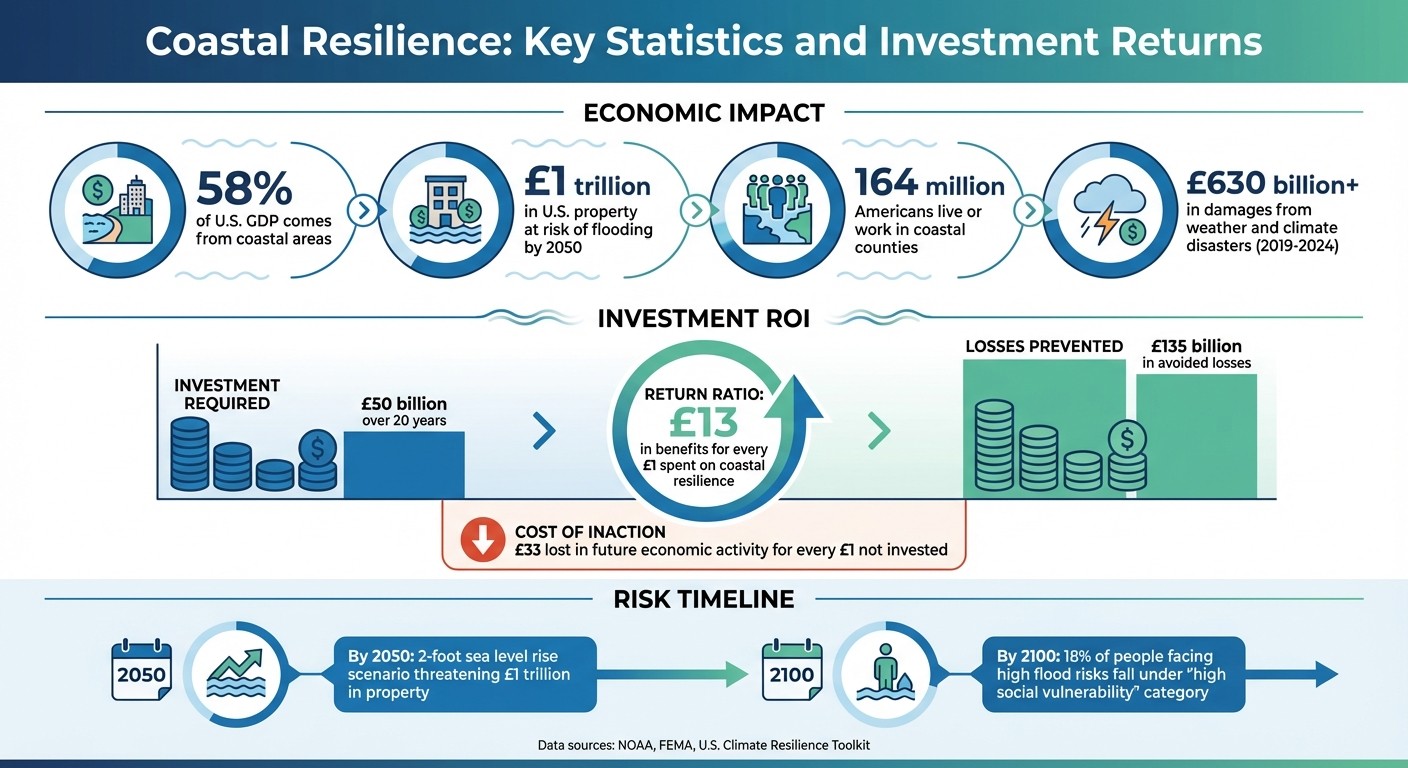
Coastal areas drive 58% of the U.S. GDP, yet face severe risks from rising sea levels and extreme weather. Over $1 trillion in U.S. property is at risk of flooding by 2050, but businesses can mitigate these threats through targeted resilience strategies. These include risk assessments, nature-based solutions like wetlands and oyster reefs, and engineered infrastructure such as seawalls and levees. Combining natural and engineered approaches can safeguard assets, reduce economic losses, and support local ecosystems. Proactive investments - $50 billion over 20 years - could prevent $135 billion in losses while ensuring long-term operational stability.
Key steps include:
Conducting Risk Assessments: Use tools like NOAA’s Sea Level Rise Viewer to identify vulnerabilities.
Implementing Nature-Based Solutions: Wetlands, dunes, and oyster reefs help absorb wave energy and reduce erosion.
Building Engineered Defenses: Seawalls, levees, and elevated infrastructure provide direct protection.
Combining Approaches: Layered defenses integrate ecological and structural measures for optimal results.
Monitoring and Collaboration: Regular updates, stakeholder input, and partnerships ensure plans stay effective.
These strategies not only protect assets but also stabilize supply chains and support workforce resilience, making them essential for businesses operating in coastal regions.
Coastal Flood Risk Statistics and ROI for Corporate Resilience Investments
New Guides to Support the Uptake of NBS to Reduce Flood Risks in Coastal Communities
Identifying Coastal Flood Risks and Vulnerabilities
Understanding coastal flood risks involves analyzing vulnerabilities and the likelihood of hazards through climate data, mapping tools, and local expertise. These evaluations form the foundation for creating effective mitigation strategies tailored to specific needs.
Running Climate Risk Assessments
A climate risk assessment helps quantify both vulnerability - how sensitive an asset is and its ability to adapt - and risk, which combines the likelihood of a hazard with its potential consequences [5]. Start with a straightforward qualitative rating (e.g., high, medium, low) to identify key assets at risk. Then, refine this analysis by incorporating detailed geospatial data and property values into a streamlined inventory [5].
When assessing hazards, establish clear probability guidelines. For example, classify an event as "high probability" if it is likely to occur within 5 years, and "medium probability" if it is expected within 5 to 20 years. These assessments should address both long-term projections (e.g., through 2100) and nearer-term operational timelines (e.g., 2050). Additionally, consider local factors like land subsidence, which can worsen the effects of sea level rise [2]. Several tools can enhance these evaluations: NOAA's Sea Level Rise Viewer offers visualizations of flooding scenarios, FEMA's National Risk Index compares risks across various natural hazards, and the Coastal Vulnerability Index evaluates risk based on factors such as tidal range, wave height, coastal slope, shoreline changes, and historical sea level trends [4] [5].
Creating Vulnerability Maps for Key Assets
Vulnerability maps turn complex data into clear, actionable visuals that highlight areas of greatest risk. These maps are essential for identifying critical assets - such as energy infrastructure, water systems, telecommunications hubs, and evacuation routes - that, if compromised, could lead to cascading failures across sectors [2] [5]. For instance, damage to a key bridge or power grid can disrupt multiple services simultaneously, emphasizing the need to focus on interconnected systems.
To create these maps, use geospatial tools like the Coastal Flood Exposure Mapper or NOAA’s Sea Level Rise Viewer to pinpoint high-risk areas and critical lifelines [2]. Concentrate on assets that combine a high probability of impact with significant potential losses, especially those essential for public safety and economic stability. These maps also guide decisions about whether to implement nature-based solutions, such as wetlands restoration, or engineered interventions like seawalls, by clearly identifying where specific approaches are needed.
Including Stakeholders in Risk Analysis
Incorporating input from both internal teams (e.g., facility managers, operations staff) and external partners (e.g., local officials, community leaders) ensures a well-rounded risk analysis. Technical data alone isn’t enough - local insights help balance analytical findings with real-world priorities. Partnering with regional organizations and neighboring counties strengthens assessments by identifying shared risks and opportunities for collaboration.
Transparency is equally important. Using accessible tools and data sources fosters public trust, while regular updates to policies on land use, zoning, and building standards ensure alignment with evolving risks. Notably, about 18% of people facing high flood risks by the end of the century fall under the "high social vulnerability" category [2]. This underscores the need to integrate physical risk assessments with a commitment to equity, ensuring that mitigation efforts address the needs of the entire community [5]. By aligning technical evaluations with community priorities, this collaborative approach lays the groundwork for effective, inclusive mitigation strategies.
Using Nature-Based Solutions for Flood Protection
Nature-based solutions, such as wetlands, dunes, and reefs, provide an effective way to safeguard coastal areas while delivering lasting environmental advantages. These approaches are often more affordable than traditional hard infrastructure and demand less maintenance over time [7]. From 2019 to 2024, weather and climate-related disasters caused over $630 billion in damages in the U.S., highlighting the need for cost-effective strategies to protect coastal businesses [6]. These solutions can also work hand-in-hand with engineered methods, creating a balanced approach to flood protection.
Living Shorelines and Wetland Restoration
Living shorelines offer a dynamic alternative to conventional flood defenses. By combining native vegetation with soft-engineered structures like stone sills, they stabilize coastlines while fostering natural habitats. Wetlands and marshes play a critical role by soaking up rainwater, slowing storm surges, and reducing wave energy before it reaches corporate facilities [6][7].
For example, the U.S. Army Corps of Engineers’ Swan Island Restoration project in the Chesapeake Bay used 60,000 cubic yards of dredged sediment and native marsh plants to combat erosion and shield the nearby town of Ewell, Maryland, from wave damage [6]. Similarly, at Morris Landing, North Carolina, stone sills and a constructed marsh were used to stabilize the shoreline, offering both structural integrity and ecological benefits [7].
The implementation process begins with site characterization, which involves analyzing historical conditions, shoreline types, and tidal patterns to identify suitable natural features [7]. Coastal engineers, ecologists, and regulatory experts are essential for planning and execution [7]. Planting should be timed to align with optimal growth periods while considering wildlife nesting seasons [7]. Performance-based contracts that encourage innovation and include long-term maintenance are key to these projects’ success [7]. While these solutions may require more frequent upkeep, such as weeding and replanting, they are better equipped to adapt to rising sea levels. Additionally, they support corporate ESG goals by creating habitats for fisheries, shellfish, and migratory birds [6][7].
Dune and Beach Reinforcement
Reinforced dunes provide a practical, nature-based solution by blending natural sand with hidden structural elements. These systems can incorporate traditional infrastructure, like cement walls, buried within sand dunes to combine durability with ecological advantages [8]. To ensure effectiveness, dunes must remain above water during storms to reduce wave energy, with studies showing that emergent dunes can lower wave heights by up to 52% [9].
Designing these systems often involves collaboration with organizations like the U.S. Army Corps of Engineers or NOAA, which use advanced modeling tools to predict flood reduction capabilities [8]. Before construction, factors such as local bathymetry, wind patterns, and tidal ranges should be thoroughly evaluated to ensure success [9]. Monitoring tools, including sediment pins and traps, can track sediment accumulation, while pressure transducers and current meters help assess wave attenuation and sediment deposition [9]. Additionally, vegetated dunes contribute to "blue carbon" storage, capturing carbon in sediments for centuries - an added benefit for companies aiming to meet carbon neutrality goals [8].
Oyster Reefs and Coastal Ecosystem Restoration
Oyster reefs serve as natural barriers, complementing other protective measures by reducing erosion and absorbing wave energy before it reaches critical assets [8][10]. These reefs can function independently or alongside traditional infrastructure to create robust, layered defense systems [8]. Beyond flood protection, they boost biodiversity, provide nursery habitats for fisheries, and aid in carbon sequestration [8].
A cost-benefit analysis can help compare the performance of oyster reefs with engineered solutions [8]. Collaboration with natural resource managers and government agencies ensures that designs are scientifically sound and effective [8]. While natural reefs maximize biodiversity, combining reefs with engineered elements may be necessary in high-energy environments to provide immediate protection while the reef establishes itself [8]. Long-term management plans are crucial to maintaining reef sustainability and performance [8]. Regular evaluations should measure flood reduction outcomes and assess the reef's ability to meet its protective goals [8]. When paired with engineered measures, oyster reefs form a comprehensive strategy for corporate coastal protection.
Using Engineered Infrastructure Solutions
Engineered infrastructure provides solid, immediate protection against storm surges and rising tides, addressing both current and future challenges. While nature-based strategies focus on building ecological resilience, these hard barriers offer clear, measurable results. According to the U.S. Climate Resilience Toolkit, "coastal hazards are increasing due to accelerating sea level rise and changing storm patterns" [1]. In the U.S. alone, property and structures worth an estimated $1 trillion face the risk of flooding from a two-foot sea-level rise, a scenario that could occur by 2050 [11].
To prepare effectively, site-specific risk assessments should be conducted using tools like the Sea Level Rise Viewer, Coastal Inundation Dashboard, and Inundation Analysis Tool [1]. These resources can help visualize potential flooding scenarios and determine whether permanent or deployable systems are the best fit.
Investing in engineered infrastructure makes sound financial sense. For every $1 spent on coastal resilience, approximately $13 in benefits and avoided recovery costs are generated [13].
"When we invest in stronger roads, flood protections, and coastal restoration, we're not just preventing damage – we're protecting livelihoods." – Massachusetts Governor Maura Healey [13]
On the flip side, delaying action can be costly, with communities potentially losing up to $33 in future economic activity for every $1 not invested [13].
Building Levees, Floodwalls, and Seawalls
Levees, floodwalls, and seawalls are vertical barriers designed to protect against high-velocity storm surges, especially in areas where space constraints make nature-based solutions insufficient. These structures can also serve dual purposes. For instance, Boston's "Raised Harborwalk" integrates floodwalls into pedestrian infrastructure, offering protection while maintaining waterfront access [12].
Incorporating freeboard - extra height above projected flood levels - provides added protection against wave action and uncertainties. Companies are encouraged to exceed minimum building codes by factoring in future sea-level rise and combined flood hazards [3]. An adaptive design approach, like New York City's East Side Coastal Resiliency project, allows for incremental modifications. This 2.4-mile system is designed for 2050 projections but can accommodate an additional two feet of elevation if sea levels rise faster than expected [14][15].
Several large-scale projects highlight the scale of investment required for robust protection. The South Shore Staten Island Project, for example, cost $615 million and included seawalls, levees, and drainage structures. Meanwhile, the Brooklyn Bridge–Montgomery Coastal Resilience project required $350 million for a one-mile stretch of barriers, and the Fire Island to Montauk Point initiative involved $1.7 billion to reinforce 83 miles of shoreline [15]. Such efforts underscore the importance of phased implementation through well-planned capital improvement strategies [3].
Raising Critical Infrastructure
Elevating buildings, equipment, and other essential assets reduces flood damage by keeping operations above projected water levels. This approach is particularly crucial in regions like Boston, where about one-sixth of the land is built on landfill, making it highly susceptible to sea-level rise. Raised infrastructure not only protects facilities but also ensures evacuation routes and access remain functional during floods. Elevated roadways, for example, can double as secondary levees for inland areas [12][13].
To safeguard critical components, businesses should focus on raising electrical systems, HVAC equipment, data centers, and manufacturing machinery to heights that account for future sea-level rise. Additional measures like dry flood-proofing (using watertight doors and sealed walls) and wet flood-proofing (employing water-resistant materials and submersible equipment) can further protect nonresidential buildings [3]. Combining flood protection with transportation infrastructure, such as raising roadways that act as both transit routes and coastal barriers, maximizes investment value. Collaborative efforts with local governments may also open opportunities for public funding [3].
Installing Surge Barriers and Pump Stations
Surge barriers are vital for preventing storm surges and high tides from moving inland through inlets, channels, and stormwater systems. Installing tidal flap valves, often called "duckbills", on stormwater pipes can further block saltwater from backing up during high tides [3].
Pump stations play a key role in managing water by actively removing it from protected areas, even during high external water levels. Submersible pump stations, which remain operational even when inundated, are particularly effective as part of a wet flood-proofing strategy that maintains functionality during prolonged flood events [3]. Proper sizing of these systems requires total water level modeling to address complex flooding scenarios involving sea-level rise, storm surges, and rainfall runoff [3].
Adopting a "No Adverse Impact" policy ensures these engineered solutions do not unintentionally increase flood risks for neighboring properties or natural ecosystems [11]. Regular maintenance and testing are essential to guarantee reliability under extreme conditions. Together, these measures strengthen a corporation’s overall flood preparedness and complement broader resilience strategies.
Combining Natural and Engineered Approaches
Protecting against floods effectively requires a combination of natural elements, such as wetlands and oyster reefs, alongside engineered structures like levees and seawalls. This layered defense system offers multiple lines of protection. Natural features serve as the first barrier, reducing wave heights and erosion through natural processes, while engineered components step in during extreme weather events for additional security [7]. Unlike traditional infrastructure, which often needs costly upgrades as sea levels rise, natural features can adapt and grow vertically under the right conditions [7].
These natural solutions offer more than just flood protection. Wetlands and reefs help filter out nitrogen and phosphorous from runoff, store carbon, and support fish populations - benefits that seawalls alone cannot provide [6][7].
"Solutions that reduce the impacts of coastal hazards... will require innovative methods and approaches that cannot be solely addressed through the use of traditional hardened infrastructure." – NOAA [6]
This hybrid approach allows for tailored solutions that combine ecological advantages with the durability of engineered systems.
Mixing Natural and Engineered Solutions
The ideal balance between natural and engineered components depends on the specific conditions of a site. In areas with high wave energy, strategies might include beach nourishment paired with offshore segmented breakwaters. Meanwhile, regions experiencing shoreline erosion could benefit from constructed salt marshes reinforced with stone sills [7]. Engineered structures often play a supporting role, shielding natural features to ensure long-term stability [7].
A thorough site assessment is crucial, factoring in elements like wind waves, boat wakes, storm surge, salinity, sunlight, and soil type [7]. The FHWA "Eco-Logical" framework can help identify locations where nature-based solutions align with existing ecological goals [7]. When selecting contractors, consider performance-based contracts that encourage innovation and include long-term maintenance plans [7].
Carefully evaluating financial and ecological factors ensures these hybrid systems provide effective and efficient protection.
Running Cost-Benefit Analysis for Resilience Investments
Financial planning for hybrid flood protection projects goes beyond upfront construction costs. Nature-based solutions are often as affordable - or even less expensive - than traditional rock revetments [7]. Their true value becomes evident after storms, as natural features typically require less expensive repairs compared to damaged structural defenses [7].
To justify investments, calculate avoided damage costs by reviewing local disaster records. For example, investing $50 billion in adaptation measures over two decades is projected to save $135 billion in avoided losses over the lifespan of those efforts [2].
Include broader benefits in your analysis. Natural features not only protect against floods but also boost local economies through recreation and commerce, improve water quality by metabolizing nutrients, and provide habitats for fish species vital to commercial fisheries [6]. These ecosystem services reduce the strain on engineered structures by dampening wave energy and absorbing rainwater, lowering overall costs [6].
Planning for Flexible, Long-Term Floodproofing
Combining natural and engineered defenses requires flexibility to adapt to changing sea levels. Instead of targeting a single endpoint like 2100, evaluate impacts over various timeframes, recognizing that different assets have different operational lifespans [2]. Tools like the Climate Explorer can help project sea-level rise and flood risks for specific locations [2].
Natural features, such as marshes and dunes, are particularly valuable for their ability to adapt and self-repair as conditions evolve [6]. However, they do require more frequent routine maintenance, such as managing invasive species and replanting vegetation, though these interventions are generally less costly than major structural repairs [7].
Adopting a "No Adverse Impact" approach ensures flood mitigation efforts don’t increase risks for nearby properties or communities [2]. For critical infrastructure like power plants or ports that cannot be relocated, focus on reinforcement and elevation while incorporating natural buffer zones [2]. Evaluate success with clear metrics, such as wave reduction and vegetation health indicators like percentage of ground cover [7].
Tracking and Improving Corporate Resilience Plans
Creating strong flood defenses is just the beginning. To ensure these measures remain effective as sea levels rise and storm patterns shift, companies must prioritize continuous monitoring and adjust their strategies over time. This requires clear performance metrics, regular feedback mechanisms, and collaboration with key partners.
Setting Up Metrics and Monitoring Systems
Monitoring coastal flooding is crucial for maintaining resilience. Tools like the Coastal Inundation Dashboard and Inundation Analysis Tool provide real-time data to track flooding frequency and depth, helping companies establish baselines and identify emerging issues. For nature-based solutions, such as restored wetlands, Sentinel Monitoring programs can confirm whether these ecosystems are adapting as intended. It’s also essential to monitor local sea-level rise trends and set measurable trigger points for upgrading systems. By keeping an eye on storm patterns and coastal hazard severity, and aligning efforts with regional initiatives like Florida's Community Resiliency Initiative, companies can build a more comprehensive approach to resilience [1]. This data-driven strategy also opens the door to incorporating valuable community insights.
Getting Stakeholder Feedback for Plan Refinement
Transparency is key to building trust. By making data sources and monitoring processes accessible, companies can encourage input from community members, local businesses, and officials, helping to identify potential blind spots. This is particularly important given that about 18% of those facing high flood risks by the end of the century fall into the "high social vulnerability" category [2]. Engaging with local stakeholders ensures that corporate efforts don’t unintentionally increase risks for surrounding communities. Regular updates on land use planning, drainage systems, and building improvements - presented in straightforward, non-technical language - can turn community feedback into opportunities for shared benefits, such as job creation and local economic growth [2]. These collaborations strengthen partnerships and can even lead to new funding opportunities.
Working with Partners and Finding Funding
Achieving large-scale resilience requires both diverse funding sources and strategic partnerships. Breaking plans into smaller, actionable phases makes it easier to secure federal grants, public-private partnerships, and regulatory incentives. This approach allows companies to address immediate risks while laying the groundwork for longer-term solutions [3]. Organizations like Council Fire specialize in connecting businesses with technical expertise and funding specifically tailored to coastal resilience. Public-private partnerships, in particular, can amplify impact by combining public funds with private investment to enhance infrastructure [3].
Conclusion: Preparing Corporations for Coastal Challenges
Building resilience against coastal threats and mitigating flood risks demands a clear, step-by-step approach. Start by assessing projected sea level changes and pinpointing critical systems at risk - such as water supplies, energy grids, and evacuation routes. From there, explore solutions like flood-proofing, raising infrastructure, or relocating assets in high-risk zones. Adopting a "No Adverse Impact" strategy ensures that any preventative measures won't inadvertently increase risks for neighboring properties or ecosystems. This structured approach allows organizations to weigh financial costs alongside comprehensive protection strategies.
The financial urgency is hard to ignore. Over $1 trillion worth of U.S. property is at risk of flooding from just two feet of sea level rise - a scenario that could occur as early as 2050. However, proactive investments in adaptation strategies, estimated at $50 billion over the next two decades, could prevent approximately $135 billion in losses over the lifespan of these measures [2].
A combined approach of natural and engineered defenses offers both immediate protection and lasting advantages. Engineered solutions like levees and seawalls provide strong, immediate barriers. Meanwhile, nature-based methods - such as wetlands restoration and oyster reefs - not only buffer waves but also enhance water filtration and store carbon in ways that adapt to changing conditions. This balanced approach protects operations while supporting the ecosystems and communities that your workforce and supply chains depend on.
Sustained success hinges on ongoing monitoring and collaboration. Regularly update building codes, share data with local communities, and build partnerships to ensure resilience plans remain effective as conditions evolve. At Council Fire, we help corporations access the technical expertise and funding needed to implement impactful coastal resilience projects.
With over 164 million Americans living or working in coastal counties - regions that contribute 58% of the nation's GDP - corporate leadership in coastal resilience extends beyond asset protection. It’s about preserving the economic backbone of entire communities and regions [2].
FAQs
What are the advantages of combining natural and engineered solutions for flood mitigation?
Combining natural and engineered flood mitigation techniques creates a well-rounded strategy for managing risks tied to flooding and erosion. Natural features like wetlands, dunes, and salt marshes play a crucial role in absorbing floodwaters, minimizing shoreline erosion, and providing lasting stability. When these are combined with engineered solutions such as levees, seawalls, or stormwater systems, the result is a layered defense system that can better adapt to changing environmental conditions.
This blended approach often proves more economical in the long run. Natural systems generally require less upkeep and come with added advantages, such as preserving habitats, enhancing water quality, and offering spaces for recreation. By integrating these methods, businesses and communities can strengthen their defenses against extreme weather, rising sea levels, and other climate-related risks, all while promoting biodiversity and building systems that are resilient and flexible.
What steps can businesses take to assess their coastal flood risks effectively?
Businesses can evaluate their coastal flood risks by leveraging tools designed to map floodplain boundaries, identify hazard zones, and predict potential storm surge effects. Taking local factors into account - such as sea level rise trends, historical flooding patterns, and storm activity - plays a key role in pinpointing specific vulnerabilities.
Collaborating with local officials and community members can uncover regional insights that help fine-tune risk management strategies. To strengthen these assessments, businesses can incorporate nature-based solutions and advanced modeling technologies, including sea level rise projections. By revisiting and updating these evaluations regularly, companies can adapt to shifting climate conditions, protect their infrastructure, and ensure smoother operations in the face of potential challenges.
Why is stakeholder involvement important in creating coastal resilience strategies?
Stakeholder involvement plays a key role in shaping coastal resilience strategies, as it promotes collaboration, incorporates a variety of perspectives, and encourages shared accountability. By bringing together residents, local businesses, government agencies, and environmental groups, companies can develop solutions that are better aligned with the unique needs and conditions of the area.
Engaging stakeholders allows for a more thorough assessment of risks, the identification of workable solutions, and an effective way to evaluate the success of resilience initiatives. This approach not only builds trust and taps into valuable local knowledge but also fosters long-term dedication to efforts that address flood risks and prepare for climate change. When collaboration is prioritized, the results are more impactful and beneficial for both businesses and the communities they serve.
Related Blog Posts
How to Build a Climate Resilience Plan for Maritime & Logistics Companies
How to Integrate Climate Risk into Infrastructure Planning for Corporations
How to Integrate Climate Risk into Infrastructure Planning for Municipalities & Government Agencies
How to Design Coastal Resilience & Flood Mitigation for Municipalities & Government Agencies
Latest Articles
©2025


FAQ
01
What does it really mean to “redefine profit”?
02
What makes Council Fire different?
03
Who does Council Fire you work with?
04
What does working with Council Fire actually look like?
05
How does Council Fire help organizations turn big goals into action?
06
How does Council Fire define and measure success?
Jan 28, 2026
How to Design Coastal Resilience & Flood Mitigation for Corporations
Sustainability Strategy
In This Article
Guidance for corporations to assess coastal flood risks and deploy nature-based and engineered defenses to protect assets, supply chains, and communities.
How to Design Coastal Resilience & Flood Mitigation for Corporations
Coastal areas drive 58% of the U.S. GDP, yet face severe risks from rising sea levels and extreme weather. Over $1 trillion in U.S. property is at risk of flooding by 2050, but businesses can mitigate these threats through targeted resilience strategies. These include risk assessments, nature-based solutions like wetlands and oyster reefs, and engineered infrastructure such as seawalls and levees. Combining natural and engineered approaches can safeguard assets, reduce economic losses, and support local ecosystems. Proactive investments - $50 billion over 20 years - could prevent $135 billion in losses while ensuring long-term operational stability.
Key steps include:
Conducting Risk Assessments: Use tools like NOAA’s Sea Level Rise Viewer to identify vulnerabilities.
Implementing Nature-Based Solutions: Wetlands, dunes, and oyster reefs help absorb wave energy and reduce erosion.
Building Engineered Defenses: Seawalls, levees, and elevated infrastructure provide direct protection.
Combining Approaches: Layered defenses integrate ecological and structural measures for optimal results.
Monitoring and Collaboration: Regular updates, stakeholder input, and partnerships ensure plans stay effective.
These strategies not only protect assets but also stabilize supply chains and support workforce resilience, making them essential for businesses operating in coastal regions.
Coastal Flood Risk Statistics and ROI for Corporate Resilience Investments
New Guides to Support the Uptake of NBS to Reduce Flood Risks in Coastal Communities
Identifying Coastal Flood Risks and Vulnerabilities
Understanding coastal flood risks involves analyzing vulnerabilities and the likelihood of hazards through climate data, mapping tools, and local expertise. These evaluations form the foundation for creating effective mitigation strategies tailored to specific needs.
Running Climate Risk Assessments
A climate risk assessment helps quantify both vulnerability - how sensitive an asset is and its ability to adapt - and risk, which combines the likelihood of a hazard with its potential consequences [5]. Start with a straightforward qualitative rating (e.g., high, medium, low) to identify key assets at risk. Then, refine this analysis by incorporating detailed geospatial data and property values into a streamlined inventory [5].
When assessing hazards, establish clear probability guidelines. For example, classify an event as "high probability" if it is likely to occur within 5 years, and "medium probability" if it is expected within 5 to 20 years. These assessments should address both long-term projections (e.g., through 2100) and nearer-term operational timelines (e.g., 2050). Additionally, consider local factors like land subsidence, which can worsen the effects of sea level rise [2]. Several tools can enhance these evaluations: NOAA's Sea Level Rise Viewer offers visualizations of flooding scenarios, FEMA's National Risk Index compares risks across various natural hazards, and the Coastal Vulnerability Index evaluates risk based on factors such as tidal range, wave height, coastal slope, shoreline changes, and historical sea level trends [4] [5].
Creating Vulnerability Maps for Key Assets
Vulnerability maps turn complex data into clear, actionable visuals that highlight areas of greatest risk. These maps are essential for identifying critical assets - such as energy infrastructure, water systems, telecommunications hubs, and evacuation routes - that, if compromised, could lead to cascading failures across sectors [2] [5]. For instance, damage to a key bridge or power grid can disrupt multiple services simultaneously, emphasizing the need to focus on interconnected systems.
To create these maps, use geospatial tools like the Coastal Flood Exposure Mapper or NOAA’s Sea Level Rise Viewer to pinpoint high-risk areas and critical lifelines [2]. Concentrate on assets that combine a high probability of impact with significant potential losses, especially those essential for public safety and economic stability. These maps also guide decisions about whether to implement nature-based solutions, such as wetlands restoration, or engineered interventions like seawalls, by clearly identifying where specific approaches are needed.
Including Stakeholders in Risk Analysis
Incorporating input from both internal teams (e.g., facility managers, operations staff) and external partners (e.g., local officials, community leaders) ensures a well-rounded risk analysis. Technical data alone isn’t enough - local insights help balance analytical findings with real-world priorities. Partnering with regional organizations and neighboring counties strengthens assessments by identifying shared risks and opportunities for collaboration.
Transparency is equally important. Using accessible tools and data sources fosters public trust, while regular updates to policies on land use, zoning, and building standards ensure alignment with evolving risks. Notably, about 18% of people facing high flood risks by the end of the century fall under the "high social vulnerability" category [2]. This underscores the need to integrate physical risk assessments with a commitment to equity, ensuring that mitigation efforts address the needs of the entire community [5]. By aligning technical evaluations with community priorities, this collaborative approach lays the groundwork for effective, inclusive mitigation strategies.
Using Nature-Based Solutions for Flood Protection
Nature-based solutions, such as wetlands, dunes, and reefs, provide an effective way to safeguard coastal areas while delivering lasting environmental advantages. These approaches are often more affordable than traditional hard infrastructure and demand less maintenance over time [7]. From 2019 to 2024, weather and climate-related disasters caused over $630 billion in damages in the U.S., highlighting the need for cost-effective strategies to protect coastal businesses [6]. These solutions can also work hand-in-hand with engineered methods, creating a balanced approach to flood protection.
Living Shorelines and Wetland Restoration
Living shorelines offer a dynamic alternative to conventional flood defenses. By combining native vegetation with soft-engineered structures like stone sills, they stabilize coastlines while fostering natural habitats. Wetlands and marshes play a critical role by soaking up rainwater, slowing storm surges, and reducing wave energy before it reaches corporate facilities [6][7].
For example, the U.S. Army Corps of Engineers’ Swan Island Restoration project in the Chesapeake Bay used 60,000 cubic yards of dredged sediment and native marsh plants to combat erosion and shield the nearby town of Ewell, Maryland, from wave damage [6]. Similarly, at Morris Landing, North Carolina, stone sills and a constructed marsh were used to stabilize the shoreline, offering both structural integrity and ecological benefits [7].
The implementation process begins with site characterization, which involves analyzing historical conditions, shoreline types, and tidal patterns to identify suitable natural features [7]. Coastal engineers, ecologists, and regulatory experts are essential for planning and execution [7]. Planting should be timed to align with optimal growth periods while considering wildlife nesting seasons [7]. Performance-based contracts that encourage innovation and include long-term maintenance are key to these projects’ success [7]. While these solutions may require more frequent upkeep, such as weeding and replanting, they are better equipped to adapt to rising sea levels. Additionally, they support corporate ESG goals by creating habitats for fisheries, shellfish, and migratory birds [6][7].
Dune and Beach Reinforcement
Reinforced dunes provide a practical, nature-based solution by blending natural sand with hidden structural elements. These systems can incorporate traditional infrastructure, like cement walls, buried within sand dunes to combine durability with ecological advantages [8]. To ensure effectiveness, dunes must remain above water during storms to reduce wave energy, with studies showing that emergent dunes can lower wave heights by up to 52% [9].
Designing these systems often involves collaboration with organizations like the U.S. Army Corps of Engineers or NOAA, which use advanced modeling tools to predict flood reduction capabilities [8]. Before construction, factors such as local bathymetry, wind patterns, and tidal ranges should be thoroughly evaluated to ensure success [9]. Monitoring tools, including sediment pins and traps, can track sediment accumulation, while pressure transducers and current meters help assess wave attenuation and sediment deposition [9]. Additionally, vegetated dunes contribute to "blue carbon" storage, capturing carbon in sediments for centuries - an added benefit for companies aiming to meet carbon neutrality goals [8].
Oyster Reefs and Coastal Ecosystem Restoration
Oyster reefs serve as natural barriers, complementing other protective measures by reducing erosion and absorbing wave energy before it reaches critical assets [8][10]. These reefs can function independently or alongside traditional infrastructure to create robust, layered defense systems [8]. Beyond flood protection, they boost biodiversity, provide nursery habitats for fisheries, and aid in carbon sequestration [8].
A cost-benefit analysis can help compare the performance of oyster reefs with engineered solutions [8]. Collaboration with natural resource managers and government agencies ensures that designs are scientifically sound and effective [8]. While natural reefs maximize biodiversity, combining reefs with engineered elements may be necessary in high-energy environments to provide immediate protection while the reef establishes itself [8]. Long-term management plans are crucial to maintaining reef sustainability and performance [8]. Regular evaluations should measure flood reduction outcomes and assess the reef's ability to meet its protective goals [8]. When paired with engineered measures, oyster reefs form a comprehensive strategy for corporate coastal protection.
Using Engineered Infrastructure Solutions
Engineered infrastructure provides solid, immediate protection against storm surges and rising tides, addressing both current and future challenges. While nature-based strategies focus on building ecological resilience, these hard barriers offer clear, measurable results. According to the U.S. Climate Resilience Toolkit, "coastal hazards are increasing due to accelerating sea level rise and changing storm patterns" [1]. In the U.S. alone, property and structures worth an estimated $1 trillion face the risk of flooding from a two-foot sea-level rise, a scenario that could occur by 2050 [11].
To prepare effectively, site-specific risk assessments should be conducted using tools like the Sea Level Rise Viewer, Coastal Inundation Dashboard, and Inundation Analysis Tool [1]. These resources can help visualize potential flooding scenarios and determine whether permanent or deployable systems are the best fit.
Investing in engineered infrastructure makes sound financial sense. For every $1 spent on coastal resilience, approximately $13 in benefits and avoided recovery costs are generated [13].
"When we invest in stronger roads, flood protections, and coastal restoration, we're not just preventing damage – we're protecting livelihoods." – Massachusetts Governor Maura Healey [13]
On the flip side, delaying action can be costly, with communities potentially losing up to $33 in future economic activity for every $1 not invested [13].
Building Levees, Floodwalls, and Seawalls
Levees, floodwalls, and seawalls are vertical barriers designed to protect against high-velocity storm surges, especially in areas where space constraints make nature-based solutions insufficient. These structures can also serve dual purposes. For instance, Boston's "Raised Harborwalk" integrates floodwalls into pedestrian infrastructure, offering protection while maintaining waterfront access [12].
Incorporating freeboard - extra height above projected flood levels - provides added protection against wave action and uncertainties. Companies are encouraged to exceed minimum building codes by factoring in future sea-level rise and combined flood hazards [3]. An adaptive design approach, like New York City's East Side Coastal Resiliency project, allows for incremental modifications. This 2.4-mile system is designed for 2050 projections but can accommodate an additional two feet of elevation if sea levels rise faster than expected [14][15].
Several large-scale projects highlight the scale of investment required for robust protection. The South Shore Staten Island Project, for example, cost $615 million and included seawalls, levees, and drainage structures. Meanwhile, the Brooklyn Bridge–Montgomery Coastal Resilience project required $350 million for a one-mile stretch of barriers, and the Fire Island to Montauk Point initiative involved $1.7 billion to reinforce 83 miles of shoreline [15]. Such efforts underscore the importance of phased implementation through well-planned capital improvement strategies [3].
Raising Critical Infrastructure
Elevating buildings, equipment, and other essential assets reduces flood damage by keeping operations above projected water levels. This approach is particularly crucial in regions like Boston, where about one-sixth of the land is built on landfill, making it highly susceptible to sea-level rise. Raised infrastructure not only protects facilities but also ensures evacuation routes and access remain functional during floods. Elevated roadways, for example, can double as secondary levees for inland areas [12][13].
To safeguard critical components, businesses should focus on raising electrical systems, HVAC equipment, data centers, and manufacturing machinery to heights that account for future sea-level rise. Additional measures like dry flood-proofing (using watertight doors and sealed walls) and wet flood-proofing (employing water-resistant materials and submersible equipment) can further protect nonresidential buildings [3]. Combining flood protection with transportation infrastructure, such as raising roadways that act as both transit routes and coastal barriers, maximizes investment value. Collaborative efforts with local governments may also open opportunities for public funding [3].
Installing Surge Barriers and Pump Stations
Surge barriers are vital for preventing storm surges and high tides from moving inland through inlets, channels, and stormwater systems. Installing tidal flap valves, often called "duckbills", on stormwater pipes can further block saltwater from backing up during high tides [3].
Pump stations play a key role in managing water by actively removing it from protected areas, even during high external water levels. Submersible pump stations, which remain operational even when inundated, are particularly effective as part of a wet flood-proofing strategy that maintains functionality during prolonged flood events [3]. Proper sizing of these systems requires total water level modeling to address complex flooding scenarios involving sea-level rise, storm surges, and rainfall runoff [3].
Adopting a "No Adverse Impact" policy ensures these engineered solutions do not unintentionally increase flood risks for neighboring properties or natural ecosystems [11]. Regular maintenance and testing are essential to guarantee reliability under extreme conditions. Together, these measures strengthen a corporation’s overall flood preparedness and complement broader resilience strategies.
Combining Natural and Engineered Approaches
Protecting against floods effectively requires a combination of natural elements, such as wetlands and oyster reefs, alongside engineered structures like levees and seawalls. This layered defense system offers multiple lines of protection. Natural features serve as the first barrier, reducing wave heights and erosion through natural processes, while engineered components step in during extreme weather events for additional security [7]. Unlike traditional infrastructure, which often needs costly upgrades as sea levels rise, natural features can adapt and grow vertically under the right conditions [7].
These natural solutions offer more than just flood protection. Wetlands and reefs help filter out nitrogen and phosphorous from runoff, store carbon, and support fish populations - benefits that seawalls alone cannot provide [6][7].
"Solutions that reduce the impacts of coastal hazards... will require innovative methods and approaches that cannot be solely addressed through the use of traditional hardened infrastructure." – NOAA [6]
This hybrid approach allows for tailored solutions that combine ecological advantages with the durability of engineered systems.
Mixing Natural and Engineered Solutions
The ideal balance between natural and engineered components depends on the specific conditions of a site. In areas with high wave energy, strategies might include beach nourishment paired with offshore segmented breakwaters. Meanwhile, regions experiencing shoreline erosion could benefit from constructed salt marshes reinforced with stone sills [7]. Engineered structures often play a supporting role, shielding natural features to ensure long-term stability [7].
A thorough site assessment is crucial, factoring in elements like wind waves, boat wakes, storm surge, salinity, sunlight, and soil type [7]. The FHWA "Eco-Logical" framework can help identify locations where nature-based solutions align with existing ecological goals [7]. When selecting contractors, consider performance-based contracts that encourage innovation and include long-term maintenance plans [7].
Carefully evaluating financial and ecological factors ensures these hybrid systems provide effective and efficient protection.
Running Cost-Benefit Analysis for Resilience Investments
Financial planning for hybrid flood protection projects goes beyond upfront construction costs. Nature-based solutions are often as affordable - or even less expensive - than traditional rock revetments [7]. Their true value becomes evident after storms, as natural features typically require less expensive repairs compared to damaged structural defenses [7].
To justify investments, calculate avoided damage costs by reviewing local disaster records. For example, investing $50 billion in adaptation measures over two decades is projected to save $135 billion in avoided losses over the lifespan of those efforts [2].
Include broader benefits in your analysis. Natural features not only protect against floods but also boost local economies through recreation and commerce, improve water quality by metabolizing nutrients, and provide habitats for fish species vital to commercial fisheries [6]. These ecosystem services reduce the strain on engineered structures by dampening wave energy and absorbing rainwater, lowering overall costs [6].
Planning for Flexible, Long-Term Floodproofing
Combining natural and engineered defenses requires flexibility to adapt to changing sea levels. Instead of targeting a single endpoint like 2100, evaluate impacts over various timeframes, recognizing that different assets have different operational lifespans [2]. Tools like the Climate Explorer can help project sea-level rise and flood risks for specific locations [2].
Natural features, such as marshes and dunes, are particularly valuable for their ability to adapt and self-repair as conditions evolve [6]. However, they do require more frequent routine maintenance, such as managing invasive species and replanting vegetation, though these interventions are generally less costly than major structural repairs [7].
Adopting a "No Adverse Impact" approach ensures flood mitigation efforts don’t increase risks for nearby properties or communities [2]. For critical infrastructure like power plants or ports that cannot be relocated, focus on reinforcement and elevation while incorporating natural buffer zones [2]. Evaluate success with clear metrics, such as wave reduction and vegetation health indicators like percentage of ground cover [7].
Tracking and Improving Corporate Resilience Plans
Creating strong flood defenses is just the beginning. To ensure these measures remain effective as sea levels rise and storm patterns shift, companies must prioritize continuous monitoring and adjust their strategies over time. This requires clear performance metrics, regular feedback mechanisms, and collaboration with key partners.
Setting Up Metrics and Monitoring Systems
Monitoring coastal flooding is crucial for maintaining resilience. Tools like the Coastal Inundation Dashboard and Inundation Analysis Tool provide real-time data to track flooding frequency and depth, helping companies establish baselines and identify emerging issues. For nature-based solutions, such as restored wetlands, Sentinel Monitoring programs can confirm whether these ecosystems are adapting as intended. It’s also essential to monitor local sea-level rise trends and set measurable trigger points for upgrading systems. By keeping an eye on storm patterns and coastal hazard severity, and aligning efforts with regional initiatives like Florida's Community Resiliency Initiative, companies can build a more comprehensive approach to resilience [1]. This data-driven strategy also opens the door to incorporating valuable community insights.
Getting Stakeholder Feedback for Plan Refinement
Transparency is key to building trust. By making data sources and monitoring processes accessible, companies can encourage input from community members, local businesses, and officials, helping to identify potential blind spots. This is particularly important given that about 18% of those facing high flood risks by the end of the century fall into the "high social vulnerability" category [2]. Engaging with local stakeholders ensures that corporate efforts don’t unintentionally increase risks for surrounding communities. Regular updates on land use planning, drainage systems, and building improvements - presented in straightforward, non-technical language - can turn community feedback into opportunities for shared benefits, such as job creation and local economic growth [2]. These collaborations strengthen partnerships and can even lead to new funding opportunities.
Working with Partners and Finding Funding
Achieving large-scale resilience requires both diverse funding sources and strategic partnerships. Breaking plans into smaller, actionable phases makes it easier to secure federal grants, public-private partnerships, and regulatory incentives. This approach allows companies to address immediate risks while laying the groundwork for longer-term solutions [3]. Organizations like Council Fire specialize in connecting businesses with technical expertise and funding specifically tailored to coastal resilience. Public-private partnerships, in particular, can amplify impact by combining public funds with private investment to enhance infrastructure [3].
Conclusion: Preparing Corporations for Coastal Challenges
Building resilience against coastal threats and mitigating flood risks demands a clear, step-by-step approach. Start by assessing projected sea level changes and pinpointing critical systems at risk - such as water supplies, energy grids, and evacuation routes. From there, explore solutions like flood-proofing, raising infrastructure, or relocating assets in high-risk zones. Adopting a "No Adverse Impact" strategy ensures that any preventative measures won't inadvertently increase risks for neighboring properties or ecosystems. This structured approach allows organizations to weigh financial costs alongside comprehensive protection strategies.
The financial urgency is hard to ignore. Over $1 trillion worth of U.S. property is at risk of flooding from just two feet of sea level rise - a scenario that could occur as early as 2050. However, proactive investments in adaptation strategies, estimated at $50 billion over the next two decades, could prevent approximately $135 billion in losses over the lifespan of these measures [2].
A combined approach of natural and engineered defenses offers both immediate protection and lasting advantages. Engineered solutions like levees and seawalls provide strong, immediate barriers. Meanwhile, nature-based methods - such as wetlands restoration and oyster reefs - not only buffer waves but also enhance water filtration and store carbon in ways that adapt to changing conditions. This balanced approach protects operations while supporting the ecosystems and communities that your workforce and supply chains depend on.
Sustained success hinges on ongoing monitoring and collaboration. Regularly update building codes, share data with local communities, and build partnerships to ensure resilience plans remain effective as conditions evolve. At Council Fire, we help corporations access the technical expertise and funding needed to implement impactful coastal resilience projects.
With over 164 million Americans living or working in coastal counties - regions that contribute 58% of the nation's GDP - corporate leadership in coastal resilience extends beyond asset protection. It’s about preserving the economic backbone of entire communities and regions [2].
FAQs
What are the advantages of combining natural and engineered solutions for flood mitigation?
Combining natural and engineered flood mitigation techniques creates a well-rounded strategy for managing risks tied to flooding and erosion. Natural features like wetlands, dunes, and salt marshes play a crucial role in absorbing floodwaters, minimizing shoreline erosion, and providing lasting stability. When these are combined with engineered solutions such as levees, seawalls, or stormwater systems, the result is a layered defense system that can better adapt to changing environmental conditions.
This blended approach often proves more economical in the long run. Natural systems generally require less upkeep and come with added advantages, such as preserving habitats, enhancing water quality, and offering spaces for recreation. By integrating these methods, businesses and communities can strengthen their defenses against extreme weather, rising sea levels, and other climate-related risks, all while promoting biodiversity and building systems that are resilient and flexible.
What steps can businesses take to assess their coastal flood risks effectively?
Businesses can evaluate their coastal flood risks by leveraging tools designed to map floodplain boundaries, identify hazard zones, and predict potential storm surge effects. Taking local factors into account - such as sea level rise trends, historical flooding patterns, and storm activity - plays a key role in pinpointing specific vulnerabilities.
Collaborating with local officials and community members can uncover regional insights that help fine-tune risk management strategies. To strengthen these assessments, businesses can incorporate nature-based solutions and advanced modeling technologies, including sea level rise projections. By revisiting and updating these evaluations regularly, companies can adapt to shifting climate conditions, protect their infrastructure, and ensure smoother operations in the face of potential challenges.
Why is stakeholder involvement important in creating coastal resilience strategies?
Stakeholder involvement plays a key role in shaping coastal resilience strategies, as it promotes collaboration, incorporates a variety of perspectives, and encourages shared accountability. By bringing together residents, local businesses, government agencies, and environmental groups, companies can develop solutions that are better aligned with the unique needs and conditions of the area.
Engaging stakeholders allows for a more thorough assessment of risks, the identification of workable solutions, and an effective way to evaluate the success of resilience initiatives. This approach not only builds trust and taps into valuable local knowledge but also fosters long-term dedication to efforts that address flood risks and prepare for climate change. When collaboration is prioritized, the results are more impactful and beneficial for both businesses and the communities they serve.
Related Blog Posts
How to Build a Climate Resilience Plan for Maritime & Logistics Companies
How to Integrate Climate Risk into Infrastructure Planning for Corporations
How to Integrate Climate Risk into Infrastructure Planning for Municipalities & Government Agencies
How to Design Coastal Resilience & Flood Mitigation for Municipalities & Government Agencies
FAQ
What does it really mean to “redefine profit”?
What makes Council Fire different?
Who does Council Fire you work with?
What does working with Council Fire actually look like?
How does Council Fire help organizations turn big goals into action?
How does Council Fire define and measure success?