
Apr 2, 2026
How to Co-Design Climate-Ready Communities with Residents for Maritime & Logistics Companies
Sustainability Strategy
In This Article
Maritime and logistics firms must co-design equitable, modular flood defenses with residents to protect operations and communities.
How to Co-Design Climate-Ready Communities with Residents for Maritime & Logistics Companies
Rising sea levels and stronger storms are reshaping the future of coastal communities and the maritime industry. For logistics and maritime companies, collaborating with local residents to design climate adaptation strategies is no longer optional - it’s a business necessity. Here's why and how this approach works:
Shared Risks, Shared Solutions: Coastal businesses and communities face overlapping threats like flooding and infrastructure damage. Engaging residents helps identify risks that technical models may miss, such as contamination from legacy industrial sites.
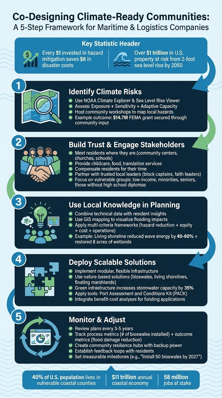
Financial Benefits: Every $1 invested in hazard mitigation saves $6 in disaster-related costs. Community-driven plans also improve access to federal and state funding, as seen in a Mid-Atlantic city securing $14.7 million for resilience projects.
Building Trust: Successful adaptation requires authentic engagement - compensating residents for their time, addressing vulnerable groups, and establishing clear communication channels.
Actionable Steps: Use tools like NOAA’s Sea Level Rise Viewer to assess risks, involve residents in mapping hazards, and prioritize modular, flexible solutions like living shorelines or bioswales.
5-Step Process for Co-Designing Climate-Ready Maritime Communities
Resilient Waterfront Design for Thriving Coastal Cities
Step 1: Identify Climate Risks in Coastal Communities
For maritime and logistics companies, understanding local climate risks is essential for crafting effective and collaborative adaptation strategies. This involves assessing three key factors: Exposure (the hazards themselves), Sensitivity (the vulnerability of infrastructure), and Adaptive Capacity (available resources to respond). This framework provides insight into not only the presence of hazards but also their interaction with infrastructure and local populations. In the U.S. alone, over $1 trillion worth of property and structures face the threat of inundation if sea levels rise by just two feet - a possibility by 2050 [5].
Collect Local Climate Data
Begin by leveraging digital tools such as the NOAA Climate Explorer, Sea Level Rise Viewer, and FEMA Flood Map Service Center to forecast future conditions and map hazard zones. A comprehensive approach, known as the total water level method, combines lunar tides, storm surges, and projected sea-level rise (analyzed at increments of 1, 2, 3, 4, 6, and 8 feet). This method helps distinguish between intermittent flooding and permanent inundation, enabling prioritization of assets requiring immediate intervention versus those needing long-term planning.
A practical example of this approach is the Adapting to Rising Tides project in Oakland. By mapping potential flood scenarios, the initiative helped the Port of Oakland and local utility agencies identify targeted measures to mitigate flood risks [4]. To complement digital mapping, develop detailed questionnaires for terminal managers and warehouse operators to evaluate current stressors, infrastructure conditions, and the consequences of potential failures.
While these tools provide a broad overview, local insights are invaluable for understanding specific challenges on the ground.
Work with Residents on Risk Assessments
Technical data alone often overlooks critical on-the-ground realities, making community input indispensable. Hosting workshops where residents map local hazards and resources can uncover risks that might otherwise go unnoticed. For instance, in a Mid-Atlantic coastal city with 28,000 residents, community workshops revealed concerns about a historically Black neighborhood near a Superfund-adjacent site. This input highlighted a compound hazard - flooding combined with contamination - that GIS modeling had not prioritized. The insights gained led to a successful $14.7 million FEMA BRIC grant application [2].
Stakeholder engagement can also include shoreline walks or driving tours to provide firsthand experience of coastal challenges. As Lindy Lowe, Program Manager of the Adapting to Rising Tides Program, explained:
"Bringing everyone together in the actual locations to experience the challenges facing the communities, infrastructure, habitats and parks helped them understand each other's concerns" [4].
To further support community involvement, translate technical findings into accessible formats. For example, Long Beach created "A Citizen's Guide to Building a Climate-Resilient Long Beach", which encouraged informed community discussions [6].
Step 2: Build Trust and Engage Stakeholders Fairly
Building trust is a cornerstone of successful climate adaptation efforts. Too often, projects falter when companies only go through the motions of community engagement. Genuine participation requires maritime and logistics companies to connect with residents on their terms. Instead of relying on sporadic public meetings, companies should adopt a relational approach that fosters long-term trust and respects local knowledge [8].
The benefits of this approach are clear. According to FEMA, every $1 invested in hazard mitigation saves $6 in disaster-related costs [1]. Gaining authentic community support not only improves project outcomes but also increases access to federal and state funding. As Council Fire highlights:
"Resilience plans that skip meaningful engagement produce technically sound documents that sit on shelves" [2].
This strategy not only secures financial resources but also strengthens the shared advantages of resilient and engaged communities.
Set Up Clear Communication Channels
Holding meetings in formal corporate or city venues can create unnecessary barriers. Instead, host sessions in places where residents feel at home, such as community centers, churches, schools, or housing complexes [1]. This localized approach has proven effective in several coastal cities, where it has uncovered overlooked hazards and helped secure federal funding [2].
To remove obstacles that prevent participation, consider providing childcare, food, and translation services. Compensate residents for their time and expertise by hiring local connectors - trusted community figures like block captains, health workers, or faith leaders [1]. While clear communication fosters trust, equitable participation empowers communities to take an active role in shaping their future.
Ensure Fair and Broad Participation
Frontline communities often face the highest risks from climate change yet have the fewest resources to influence adaptation plans. The EPA identifies particularly vulnerable groups as those with incomes at or below 200% of the poverty level, minority populations, individuals without a high school diploma, and people aged 65 and older [7]. It’s vital to involve leaders from these groups early in the planning process, rather than after decisions have already been made [7].
Effective engagement means looking beyond elected officials to find civic and neighborhood leaders who are naturally trusted by residents. For individuals who lack direct representation - such as those experiencing homelessness - partnering with community-based organizations like food banks, shelters, or senior centers can ensure their needs are addressed [7]. A great example of this inclusive approach comes from the San Francisco Bay Adapting to Rising Tides (ART) project. By using local socioeconomic data to map social vulnerabilities alongside flooding risks, the project ensured diverse stakeholders had a meaningful role in planning [3]. Lindy Lowe, Program Manager for the ART Program, emphasized this collaborative effort:
"The ART approach was developed to emphasize close collaboration and build the trusted relationships that allow both buy-in for the findings and for future action" [4].
To make climate risks more relatable, tools like GIS hazard mapping and sea-level rise viewers can help residents visualize how these issues affect their daily lives [3]. Additionally, diversify outreach by providing materials in multiple languages and using methods like door-to-door visits and text alerts to engage as many residents as possible.
Step 3: Use Local Knowledge in Climate Adaptation Plans
Once community engagement has been established and insights have been gathered, the next step is to convert this input into specific, actionable infrastructure solutions. By using structured frameworks that balance community priorities with operational needs, you can ensure both groups benefit without pitting their interests against one another.
Apply Community Input to Infrastructure Planning
Local residents often have firsthand knowledge of risks that technical models might miss. Their input can uncover hidden, interconnected hazards - like the combination of flooding and legacy contamination - that standard projections fail to catch. For instance, in a Mid-Atlantic coastal city, community-driven insights led to the creation of a living shoreline project. This initiative not only reduced wave energy by 40–60% during storms but also restored 8 acres of tidal wetlands [2].
Visualization tools like GIS mapping and NOAA's Sea Level Rise Viewer can help residents understand how potential flooding might affect their neighborhoods. These tools encourage more productive discussions about where to place infrastructure. A great example comes from the San Francisco Bay Conservation and Development Commission, which used detailed topographic data to show how rising sea levels could impact both industrial and residential areas. This data guided targeted flood-reduction efforts at critical infrastructure points [3].
Field trips to shoreline assets can also be invaluable. Organizing visits with a mix of stakeholders - such as port authorities, residents, and business managers - can uncover unexpected links between hazards and concerns. These shared experiences often strengthen collaboration and problem-solving.
As technical data is combined with local knowledge, it’s important to align these insights with operational priorities to create effective plans.
Balance Local Needs with Business Goals
Using community input to guide plans ensures that adaptation strategies are both practical and responsive. Multi-criteria frameworks can help evaluate solutions by considering factors like hazard reduction, equity impacts, cost-effectiveness, and operational benefits [2]. This approach ensures that projects address both community needs and business objectives.
To make resilience investments more appealing, express their benefits in financial terms. For instance, every $1 spent on hazard mitigation saves an average of $6 in future disaster costs [1]. Structuring plans to align with federal funding criteria - such as including benefit-cost analyses and equity scoring - can also make them more competitive for grants [2].
Adaptation projects can often deliver multiple advantages. Take green infrastructure as an example: bioswales and rain gardens can increase stormwater system capacity by up to 35% during major storms, while also creating attractive community spaces [2]. A collaborative effort by the Port of Oakland and local residents under the ART project illustrates how collective processes can lead to consensus on resilience actions. Lindy Lowe highlighted this dynamic:
"The process of working together to understand the vulnerabilities and the relationships between the vulnerabilities made reaching agreement much easier when determining the actions to take to increase resilience" [4].
Step 4: Deploy Scalable Co-Design Solutions
Once community input and business priorities are aligned, the next move is to implement infrastructure solutions that can adapt and expand as climate risks evolve. These solutions, informed by earlier risk assessments and community engagement, aim to ensure operational continuity while addressing the needs of local residents.
Use Modular and Flexible Solutions
Modular systems provide adaptability to uncertain future conditions. Instead of relying on static, large-scale barriers, consider designs that can be adjusted as conditions change. A prime example is the Emerald Tutu project, initiated by Dr. Julia Hopkins at Northeastern University in 2018. This system features floating mesh mats layered with seaweed and marshland, which can be repositioned to accommodate shipping lanes and water traffic. At the same time, these mats reduce wave energy to protect urban areas like Boston [9].
Ports benefit from incremental upgrades to avoid major disruptions. Andy Raichle, Executive Vice President at Bowman, highlights the balance needed in designing resilient infrastructure:
"Resiliency is fundamentally about the ability to recover from adversity, and we are often tasked with determining the 'right' level of protection. Too much protection can hinder port operations - for example, raising a dock too high to efficiently service berthed ships" [10].
Rather than a single large-scale upgrade, gradual dock elevation adjustments can maintain operational efficiency while enhancing protection over time.
Nature-based solutions offer dual benefits for operations and communities. Hardening critical assets like electrical substations is essential for business continuity, but incorporating living shorelines can also restore habitats and create recreational spaces for residents. Paul Kirshen, Director of the Stone Living Lab, underscores the flexibility of these approaches:
"The advantage of these nature-based systems is you can build them as you need them. You have this incredible flexibility and adaptation to deal with the uncertainty of the future sea-level rise" [9].
Green infrastructure, such as bioswales and rain gardens, can be distributed across watersheds, forming a network that evolves alongside community needs. These modular systems allow for targeted deployment, a process enhanced by digital planning tools.
Apply Tools for Climate Resilience Planning
Advanced tools like the Port Assessment and Conditions Kit (PACK) provide critical insights. Using multi-beam and lidar technology, PACK generates detailed vulnerability maps of marine structures, identifying weak points in components like piles and superstructures. This data supports long-term planning by highlighting which assets are most at risk [10].
The total water level approach addresses both current and future flooding risks. By mapping water levels from 1 to 8 feet, the Port of Oakland and the San Francisco Bay Conservation and Development Commission identified assets that could tolerate temporary flooding, such as parks, and those that required permanent protection, like terminals [4].
These tools not only guide the precise placement of solutions but also enhance funding applications. Council Fire's strategic framework integrates benefit-cost analyses and equity scoring to maximize funding potential. For instance, in February 2026, a Mid-Atlantic coastal city with 28,000 residents used this approach to secure $14.7 million in grants within 18 months. The project safeguarded $4.2 billion in property value with a 1.2-mile living shoreline and established two resilience hubs equipped with backup power and communication systems. By incorporating these analyses from the outset, the city's FEMA BRIC application ranked in the top 15% nationally [2].
Step 5: Monitor, Evaluate, and Adjust Through Collaboration
Building climate resilience isn’t a one-and-done effort - it’s a continuous cycle. Once measures are in place, it’s crucial to track their performance and refine strategies every 3–5 years, incorporating fresh data, lessons from recent events, and input from residents [1]. This ongoing process ensures that plans stay relevant and effective over time.
Set Up Real-Time Monitoring Systems
To measure success, it’s important to track both the steps taken and the results achieved. For instance, process metrics like the number of bioswales installed can show progress, while outcome metrics, such as reduced flood damage, reveal the tangible impact [1]. Consider the case of a Mid-Atlantic coastal city where annual tidal flooding days surged from 12 in 2010 to 37 by 2023. This stark increase highlighted the need to speed up adaptation efforts [2].
Specialized tools are invaluable for this kind of monitoring. The EPA’s Storm Water Management Model (SWMM) and approaches like "total water level" tracking provide real-time insights into changing conditions. Tidal flooding frequency, for example, can be monitored through primary gauge stations, which alert operators when flooding exceeds historical averages. These tools not only help evaluate current measures but also shape future strategies.
Create Feedback Loops with Residents
While data-driven systems are essential, they’re only part of the equation. Resident feedback ensures that adaptation strategies stay in sync with community needs. Collaboration doesn’t end when construction begins - it must remain an active part of the process. A great example is the San Francisco Bay Conservation and Development Commission’s Adapting to Rising Tides (ART) project. Since 2010, the initiative has used tools like the Sea Level Rise Viewer to make complex climate data accessible to residents. Program Manager Lindy Lowe explained:
"Many of these organizations have not worked together, so the ART approach was developed to emphasize close collaboration and build the trusted relationships that allow both buy-in for the findings and for future action" [4].
Community resilience hubs can play a key role in fostering this collaboration. These hubs - often located in community centers or churches equipped with backup power and communications - serve as permanent spaces for gathering feedback and coordinating emergency responses [2]. By combining technical data with community insights, these hubs ensure that adaptation measures remain effective and inclusive.
Set Measurable Milestones and Conduct Regular Reviews
Clear, specific goals make it easier to track progress and make adjustments. For example, instead of setting a general goal like "improve stormwater management", aim for something concrete, such as "Install 50 bioswales in flood-prone zones by 2027" [1]. Regular reviews, such as quarterly check-ins for active projects, can help identify and resolve issues early on, preventing setbacks in later phases [11].
The financial benefits of this approach are also compelling. According to FEMA, every $1 spent on hazard mitigation saves $6 in avoided disaster costs [1]. This underscores the value of continuous monitoring and collaboration as not just a practical strategy but a smart investment in long-term resilience.
Case Studies: Maritime Co-Design Initiatives That Worked
These examples showcase how co-design strategies have successfully transformed maritime and logistics operations, blending community collaboration with measurable outcomes in financial and environmental performance.
One standout example comes from a major East Coast port authority that undertook a large-scale sustainability project spanning 2,800 acres between 2021 and 2026. By transitioning 65% of its cargo handling equipment to electric, the port slashed per-unit energy costs by 65% compared to diesel, saving an impressive US$48 million in fuel costs. Additionally, 12 megawatts of solar power were installed on terminal rooftops, further enhancing efficiency. Over five years, the initiative delivered US$125 million in cumulative savings, achieved a 52% reduction in Scope 1 and 2 emissions, and improved air quality in nearby neighborhoods, with PM2.5 levels dropping by 31%. This reduction contributed to fewer pediatric asthma emergency visits in the area [12].
In New Bedford, Massachusetts, a port generating US$11 billion annually and employing over 6,800 people faced serious climate threats in 2020. The city responded with the "NB Resilient" initiative, starting with an investment of US$208,000. This program emphasized community involvement by appointing resilience ambassadors, conducting boat tours for city leaders to witness sea-level rise impacts firsthand, and developing an interactive coastal viewer tool. These efforts led to the creation of Resilient Design Guidelines and a Maritime Business Resilient Toolkit, which have since become essential resources for port infrastructure planning and local zoning regulations [13].
The San Francisco Bay Conservation and Development Commission's Adapting to Rising Tides (ART) project, launched in 2010, showcased strong regional collaboration. By integrating high-resolution topographic data with social vulnerability mapping, the initiative strengthened infrastructure planning across Alameda County and the larger Bay Area. The publicly available Sea Level Rise Viewer now aids municipal leaders in identifying vulnerabilities and prioritizing investments. The project demonstrated the value of building trusted relationships to foster stakeholder support and guide future actions [3].
Another example from a Mid-Atlantic coastal city highlights the benefits of inclusive engagement. By actively involving the community in resilience planning, the city secured US$14.7 million in grants. This approach emphasized how integrating local knowledge with strategic planning can uncover hidden risks and unlock funding opportunities [2]. These cases underscore the importance of tailored collaboration and innovative approaches in addressing complex maritime challenges.
Conclusion: Key Takeaways for Creating Climate-Ready Communities
Building climate-resilient communities isn't just a moral responsibility - it’s a practical necessity for maritime and logistics companies. With over 40% of the U.S. population residing in coastal counties that are increasingly vulnerable to climate impacts, the stakes are enormous. Without action, annual property losses could climb to $146 billion by 2090. However, there’s a silver lining: for every dollar spent on hazard mitigation, an estimated $6 is saved in avoided disaster costs, making proactive collaboration a wise investment [14][15][1].
The most impactful co-design efforts prioritize equity and actively involve frontline communities. As Council Fire resources highlight, resilience plans lacking genuine community engagement often result in reports that gather dust instead of driving action [2]. To avoid this pitfall, maritime companies need to move beyond surface-level consultations. This means compensating residents for their expertise, forming partnerships with trusted local organizations, and creating governance structures that empower communities with real decision-making authority [1][15].
Aligning business objectives with community resilience is key to scalability. Coastal economies generate $11 trillion annually for the U.S. GDP and support over 58 million jobs [15]. Safeguarding this vital economic sector requires strategic investments in workforce development for blue-green industries, early alignment with federal grant requirements, and the creation of resilience hubs that serve dual purposes - disaster response and strengthening community bonds [1][2][15].
Achieving maritime emission reduction targets - 40% by 2030 and 70% by 2040 - will also hinge on strong community partnerships [16]. Ports and logistics facilities must collaborate closely with the communities they operate in to balance sustainability goals with operational efficiency. As Patricia Stathatou from Georgia Tech aptly puts it:
"If we are to make a difference in the industry in regard to climate, we need partnerships with shipping companies to help guide their efforts" [16].
FAQs
How do we start co-design with residents?
To create effective resilience strategies, it’s crucial to involve the community from the beginning. Start with a community-level vulnerability assessment that includes mapping hazard zones and forecasting future climate scenarios. Make this process collaborative by actively engaging residents, gathering their input, and incorporating their lived experiences. Build trust through open and inclusive conversations, such as listening sessions and participatory planning workshops. Transparent communication and genuine collaboration ensure that the resulting strategies are tailored to the community’s unique challenges while laying the groundwork for broader, adaptable climate resilience solutions.
What tools should we use to map flood risk?
To assess flood risks accurately, consider using resources like the Coastal Flood Exposure Mapper available through the U.S. Climate Resilience Toolkit. This tool offers detailed maps of coastal flooding zones, serving as a valuable asset for resilience planning efforts. Additionally, working closely with local, state, and federal agencies to incorporate updated floodplain data and climate projections is crucial. These strategies enable better identification of hazard areas, prioritization of vulnerable regions, and more informed decision-making to address climate challenges effectively.
How do we pay for resilience projects?
Funding for resilience projects typically relies on a mix of government budgets, community investments, and grants. To secure these resources, strategic planning plays a critical role. This involves engaging stakeholders and conducting vulnerability assessments to pinpoint areas of need and opportunity. For instance, incorporating economic considerations - such as property values and infrastructure costs - into the planning process can open doors to funding through local partnerships, municipal budgets, or external grants. Aligning these approaches helps ensure financial backing for essential infrastructure upgrades and climate adaptation initiatives.
Related Blog Posts
How to Build a Climate Resilience Plan for Maritime & Logistics Companies
How to Integrate Climate Risk into Infrastructure Planning for Maritime & Logistics Companies
How to Design Coastal Resilience & Flood Mitigation for Maritime & Logistics Companies
How to Co-Design Climate-Ready Communities with Residents for Municipalities & Government Agencies
Latest Articles
©2025


FAQ
01
What does it really mean to “redefine profit”?
02
What makes Council Fire different?
03
Who does Council Fire you work with?
04
What does working with Council Fire actually look like?
05
How does Council Fire help organizations turn big goals into action?
06
How does Council Fire define and measure success?
Apr 2, 2026
How to Co-Design Climate-Ready Communities with Residents for Maritime & Logistics Companies
Sustainability Strategy
In This Article
Maritime and logistics firms must co-design equitable, modular flood defenses with residents to protect operations and communities.
How to Co-Design Climate-Ready Communities with Residents for Maritime & Logistics Companies
Rising sea levels and stronger storms are reshaping the future of coastal communities and the maritime industry. For logistics and maritime companies, collaborating with local residents to design climate adaptation strategies is no longer optional - it’s a business necessity. Here's why and how this approach works:
Shared Risks, Shared Solutions: Coastal businesses and communities face overlapping threats like flooding and infrastructure damage. Engaging residents helps identify risks that technical models may miss, such as contamination from legacy industrial sites.
Financial Benefits: Every $1 invested in hazard mitigation saves $6 in disaster-related costs. Community-driven plans also improve access to federal and state funding, as seen in a Mid-Atlantic city securing $14.7 million for resilience projects.
Building Trust: Successful adaptation requires authentic engagement - compensating residents for their time, addressing vulnerable groups, and establishing clear communication channels.
Actionable Steps: Use tools like NOAA’s Sea Level Rise Viewer to assess risks, involve residents in mapping hazards, and prioritize modular, flexible solutions like living shorelines or bioswales.
5-Step Process for Co-Designing Climate-Ready Maritime Communities
Resilient Waterfront Design for Thriving Coastal Cities
Step 1: Identify Climate Risks in Coastal Communities
For maritime and logistics companies, understanding local climate risks is essential for crafting effective and collaborative adaptation strategies. This involves assessing three key factors: Exposure (the hazards themselves), Sensitivity (the vulnerability of infrastructure), and Adaptive Capacity (available resources to respond). This framework provides insight into not only the presence of hazards but also their interaction with infrastructure and local populations. In the U.S. alone, over $1 trillion worth of property and structures face the threat of inundation if sea levels rise by just two feet - a possibility by 2050 [5].
Collect Local Climate Data
Begin by leveraging digital tools such as the NOAA Climate Explorer, Sea Level Rise Viewer, and FEMA Flood Map Service Center to forecast future conditions and map hazard zones. A comprehensive approach, known as the total water level method, combines lunar tides, storm surges, and projected sea-level rise (analyzed at increments of 1, 2, 3, 4, 6, and 8 feet). This method helps distinguish between intermittent flooding and permanent inundation, enabling prioritization of assets requiring immediate intervention versus those needing long-term planning.
A practical example of this approach is the Adapting to Rising Tides project in Oakland. By mapping potential flood scenarios, the initiative helped the Port of Oakland and local utility agencies identify targeted measures to mitigate flood risks [4]. To complement digital mapping, develop detailed questionnaires for terminal managers and warehouse operators to evaluate current stressors, infrastructure conditions, and the consequences of potential failures.
While these tools provide a broad overview, local insights are invaluable for understanding specific challenges on the ground.
Work with Residents on Risk Assessments
Technical data alone often overlooks critical on-the-ground realities, making community input indispensable. Hosting workshops where residents map local hazards and resources can uncover risks that might otherwise go unnoticed. For instance, in a Mid-Atlantic coastal city with 28,000 residents, community workshops revealed concerns about a historically Black neighborhood near a Superfund-adjacent site. This input highlighted a compound hazard - flooding combined with contamination - that GIS modeling had not prioritized. The insights gained led to a successful $14.7 million FEMA BRIC grant application [2].
Stakeholder engagement can also include shoreline walks or driving tours to provide firsthand experience of coastal challenges. As Lindy Lowe, Program Manager of the Adapting to Rising Tides Program, explained:
"Bringing everyone together in the actual locations to experience the challenges facing the communities, infrastructure, habitats and parks helped them understand each other's concerns" [4].
To further support community involvement, translate technical findings into accessible formats. For example, Long Beach created "A Citizen's Guide to Building a Climate-Resilient Long Beach", which encouraged informed community discussions [6].
Step 2: Build Trust and Engage Stakeholders Fairly
Building trust is a cornerstone of successful climate adaptation efforts. Too often, projects falter when companies only go through the motions of community engagement. Genuine participation requires maritime and logistics companies to connect with residents on their terms. Instead of relying on sporadic public meetings, companies should adopt a relational approach that fosters long-term trust and respects local knowledge [8].
The benefits of this approach are clear. According to FEMA, every $1 invested in hazard mitigation saves $6 in disaster-related costs [1]. Gaining authentic community support not only improves project outcomes but also increases access to federal and state funding. As Council Fire highlights:
"Resilience plans that skip meaningful engagement produce technically sound documents that sit on shelves" [2].
This strategy not only secures financial resources but also strengthens the shared advantages of resilient and engaged communities.
Set Up Clear Communication Channels
Holding meetings in formal corporate or city venues can create unnecessary barriers. Instead, host sessions in places where residents feel at home, such as community centers, churches, schools, or housing complexes [1]. This localized approach has proven effective in several coastal cities, where it has uncovered overlooked hazards and helped secure federal funding [2].
To remove obstacles that prevent participation, consider providing childcare, food, and translation services. Compensate residents for their time and expertise by hiring local connectors - trusted community figures like block captains, health workers, or faith leaders [1]. While clear communication fosters trust, equitable participation empowers communities to take an active role in shaping their future.
Ensure Fair and Broad Participation
Frontline communities often face the highest risks from climate change yet have the fewest resources to influence adaptation plans. The EPA identifies particularly vulnerable groups as those with incomes at or below 200% of the poverty level, minority populations, individuals without a high school diploma, and people aged 65 and older [7]. It’s vital to involve leaders from these groups early in the planning process, rather than after decisions have already been made [7].
Effective engagement means looking beyond elected officials to find civic and neighborhood leaders who are naturally trusted by residents. For individuals who lack direct representation - such as those experiencing homelessness - partnering with community-based organizations like food banks, shelters, or senior centers can ensure their needs are addressed [7]. A great example of this inclusive approach comes from the San Francisco Bay Adapting to Rising Tides (ART) project. By using local socioeconomic data to map social vulnerabilities alongside flooding risks, the project ensured diverse stakeholders had a meaningful role in planning [3]. Lindy Lowe, Program Manager for the ART Program, emphasized this collaborative effort:
"The ART approach was developed to emphasize close collaboration and build the trusted relationships that allow both buy-in for the findings and for future action" [4].
To make climate risks more relatable, tools like GIS hazard mapping and sea-level rise viewers can help residents visualize how these issues affect their daily lives [3]. Additionally, diversify outreach by providing materials in multiple languages and using methods like door-to-door visits and text alerts to engage as many residents as possible.
Step 3: Use Local Knowledge in Climate Adaptation Plans
Once community engagement has been established and insights have been gathered, the next step is to convert this input into specific, actionable infrastructure solutions. By using structured frameworks that balance community priorities with operational needs, you can ensure both groups benefit without pitting their interests against one another.
Apply Community Input to Infrastructure Planning
Local residents often have firsthand knowledge of risks that technical models might miss. Their input can uncover hidden, interconnected hazards - like the combination of flooding and legacy contamination - that standard projections fail to catch. For instance, in a Mid-Atlantic coastal city, community-driven insights led to the creation of a living shoreline project. This initiative not only reduced wave energy by 40–60% during storms but also restored 8 acres of tidal wetlands [2].
Visualization tools like GIS mapping and NOAA's Sea Level Rise Viewer can help residents understand how potential flooding might affect their neighborhoods. These tools encourage more productive discussions about where to place infrastructure. A great example comes from the San Francisco Bay Conservation and Development Commission, which used detailed topographic data to show how rising sea levels could impact both industrial and residential areas. This data guided targeted flood-reduction efforts at critical infrastructure points [3].
Field trips to shoreline assets can also be invaluable. Organizing visits with a mix of stakeholders - such as port authorities, residents, and business managers - can uncover unexpected links between hazards and concerns. These shared experiences often strengthen collaboration and problem-solving.
As technical data is combined with local knowledge, it’s important to align these insights with operational priorities to create effective plans.
Balance Local Needs with Business Goals
Using community input to guide plans ensures that adaptation strategies are both practical and responsive. Multi-criteria frameworks can help evaluate solutions by considering factors like hazard reduction, equity impacts, cost-effectiveness, and operational benefits [2]. This approach ensures that projects address both community needs and business objectives.
To make resilience investments more appealing, express their benefits in financial terms. For instance, every $1 spent on hazard mitigation saves an average of $6 in future disaster costs [1]. Structuring plans to align with federal funding criteria - such as including benefit-cost analyses and equity scoring - can also make them more competitive for grants [2].
Adaptation projects can often deliver multiple advantages. Take green infrastructure as an example: bioswales and rain gardens can increase stormwater system capacity by up to 35% during major storms, while also creating attractive community spaces [2]. A collaborative effort by the Port of Oakland and local residents under the ART project illustrates how collective processes can lead to consensus on resilience actions. Lindy Lowe highlighted this dynamic:
"The process of working together to understand the vulnerabilities and the relationships between the vulnerabilities made reaching agreement much easier when determining the actions to take to increase resilience" [4].
Step 4: Deploy Scalable Co-Design Solutions
Once community input and business priorities are aligned, the next move is to implement infrastructure solutions that can adapt and expand as climate risks evolve. These solutions, informed by earlier risk assessments and community engagement, aim to ensure operational continuity while addressing the needs of local residents.
Use Modular and Flexible Solutions
Modular systems provide adaptability to uncertain future conditions. Instead of relying on static, large-scale barriers, consider designs that can be adjusted as conditions change. A prime example is the Emerald Tutu project, initiated by Dr. Julia Hopkins at Northeastern University in 2018. This system features floating mesh mats layered with seaweed and marshland, which can be repositioned to accommodate shipping lanes and water traffic. At the same time, these mats reduce wave energy to protect urban areas like Boston [9].
Ports benefit from incremental upgrades to avoid major disruptions. Andy Raichle, Executive Vice President at Bowman, highlights the balance needed in designing resilient infrastructure:
"Resiliency is fundamentally about the ability to recover from adversity, and we are often tasked with determining the 'right' level of protection. Too much protection can hinder port operations - for example, raising a dock too high to efficiently service berthed ships" [10].
Rather than a single large-scale upgrade, gradual dock elevation adjustments can maintain operational efficiency while enhancing protection over time.
Nature-based solutions offer dual benefits for operations and communities. Hardening critical assets like electrical substations is essential for business continuity, but incorporating living shorelines can also restore habitats and create recreational spaces for residents. Paul Kirshen, Director of the Stone Living Lab, underscores the flexibility of these approaches:
"The advantage of these nature-based systems is you can build them as you need them. You have this incredible flexibility and adaptation to deal with the uncertainty of the future sea-level rise" [9].
Green infrastructure, such as bioswales and rain gardens, can be distributed across watersheds, forming a network that evolves alongside community needs. These modular systems allow for targeted deployment, a process enhanced by digital planning tools.
Apply Tools for Climate Resilience Planning
Advanced tools like the Port Assessment and Conditions Kit (PACK) provide critical insights. Using multi-beam and lidar technology, PACK generates detailed vulnerability maps of marine structures, identifying weak points in components like piles and superstructures. This data supports long-term planning by highlighting which assets are most at risk [10].
The total water level approach addresses both current and future flooding risks. By mapping water levels from 1 to 8 feet, the Port of Oakland and the San Francisco Bay Conservation and Development Commission identified assets that could tolerate temporary flooding, such as parks, and those that required permanent protection, like terminals [4].
These tools not only guide the precise placement of solutions but also enhance funding applications. Council Fire's strategic framework integrates benefit-cost analyses and equity scoring to maximize funding potential. For instance, in February 2026, a Mid-Atlantic coastal city with 28,000 residents used this approach to secure $14.7 million in grants within 18 months. The project safeguarded $4.2 billion in property value with a 1.2-mile living shoreline and established two resilience hubs equipped with backup power and communication systems. By incorporating these analyses from the outset, the city's FEMA BRIC application ranked in the top 15% nationally [2].
Step 5: Monitor, Evaluate, and Adjust Through Collaboration
Building climate resilience isn’t a one-and-done effort - it’s a continuous cycle. Once measures are in place, it’s crucial to track their performance and refine strategies every 3–5 years, incorporating fresh data, lessons from recent events, and input from residents [1]. This ongoing process ensures that plans stay relevant and effective over time.
Set Up Real-Time Monitoring Systems
To measure success, it’s important to track both the steps taken and the results achieved. For instance, process metrics like the number of bioswales installed can show progress, while outcome metrics, such as reduced flood damage, reveal the tangible impact [1]. Consider the case of a Mid-Atlantic coastal city where annual tidal flooding days surged from 12 in 2010 to 37 by 2023. This stark increase highlighted the need to speed up adaptation efforts [2].
Specialized tools are invaluable for this kind of monitoring. The EPA’s Storm Water Management Model (SWMM) and approaches like "total water level" tracking provide real-time insights into changing conditions. Tidal flooding frequency, for example, can be monitored through primary gauge stations, which alert operators when flooding exceeds historical averages. These tools not only help evaluate current measures but also shape future strategies.
Create Feedback Loops with Residents
While data-driven systems are essential, they’re only part of the equation. Resident feedback ensures that adaptation strategies stay in sync with community needs. Collaboration doesn’t end when construction begins - it must remain an active part of the process. A great example is the San Francisco Bay Conservation and Development Commission’s Adapting to Rising Tides (ART) project. Since 2010, the initiative has used tools like the Sea Level Rise Viewer to make complex climate data accessible to residents. Program Manager Lindy Lowe explained:
"Many of these organizations have not worked together, so the ART approach was developed to emphasize close collaboration and build the trusted relationships that allow both buy-in for the findings and for future action" [4].
Community resilience hubs can play a key role in fostering this collaboration. These hubs - often located in community centers or churches equipped with backup power and communications - serve as permanent spaces for gathering feedback and coordinating emergency responses [2]. By combining technical data with community insights, these hubs ensure that adaptation measures remain effective and inclusive.
Set Measurable Milestones and Conduct Regular Reviews
Clear, specific goals make it easier to track progress and make adjustments. For example, instead of setting a general goal like "improve stormwater management", aim for something concrete, such as "Install 50 bioswales in flood-prone zones by 2027" [1]. Regular reviews, such as quarterly check-ins for active projects, can help identify and resolve issues early on, preventing setbacks in later phases [11].
The financial benefits of this approach are also compelling. According to FEMA, every $1 spent on hazard mitigation saves $6 in avoided disaster costs [1]. This underscores the value of continuous monitoring and collaboration as not just a practical strategy but a smart investment in long-term resilience.
Case Studies: Maritime Co-Design Initiatives That Worked
These examples showcase how co-design strategies have successfully transformed maritime and logistics operations, blending community collaboration with measurable outcomes in financial and environmental performance.
One standout example comes from a major East Coast port authority that undertook a large-scale sustainability project spanning 2,800 acres between 2021 and 2026. By transitioning 65% of its cargo handling equipment to electric, the port slashed per-unit energy costs by 65% compared to diesel, saving an impressive US$48 million in fuel costs. Additionally, 12 megawatts of solar power were installed on terminal rooftops, further enhancing efficiency. Over five years, the initiative delivered US$125 million in cumulative savings, achieved a 52% reduction in Scope 1 and 2 emissions, and improved air quality in nearby neighborhoods, with PM2.5 levels dropping by 31%. This reduction contributed to fewer pediatric asthma emergency visits in the area [12].
In New Bedford, Massachusetts, a port generating US$11 billion annually and employing over 6,800 people faced serious climate threats in 2020. The city responded with the "NB Resilient" initiative, starting with an investment of US$208,000. This program emphasized community involvement by appointing resilience ambassadors, conducting boat tours for city leaders to witness sea-level rise impacts firsthand, and developing an interactive coastal viewer tool. These efforts led to the creation of Resilient Design Guidelines and a Maritime Business Resilient Toolkit, which have since become essential resources for port infrastructure planning and local zoning regulations [13].
The San Francisco Bay Conservation and Development Commission's Adapting to Rising Tides (ART) project, launched in 2010, showcased strong regional collaboration. By integrating high-resolution topographic data with social vulnerability mapping, the initiative strengthened infrastructure planning across Alameda County and the larger Bay Area. The publicly available Sea Level Rise Viewer now aids municipal leaders in identifying vulnerabilities and prioritizing investments. The project demonstrated the value of building trusted relationships to foster stakeholder support and guide future actions [3].
Another example from a Mid-Atlantic coastal city highlights the benefits of inclusive engagement. By actively involving the community in resilience planning, the city secured US$14.7 million in grants. This approach emphasized how integrating local knowledge with strategic planning can uncover hidden risks and unlock funding opportunities [2]. These cases underscore the importance of tailored collaboration and innovative approaches in addressing complex maritime challenges.
Conclusion: Key Takeaways for Creating Climate-Ready Communities
Building climate-resilient communities isn't just a moral responsibility - it’s a practical necessity for maritime and logistics companies. With over 40% of the U.S. population residing in coastal counties that are increasingly vulnerable to climate impacts, the stakes are enormous. Without action, annual property losses could climb to $146 billion by 2090. However, there’s a silver lining: for every dollar spent on hazard mitigation, an estimated $6 is saved in avoided disaster costs, making proactive collaboration a wise investment [14][15][1].
The most impactful co-design efforts prioritize equity and actively involve frontline communities. As Council Fire resources highlight, resilience plans lacking genuine community engagement often result in reports that gather dust instead of driving action [2]. To avoid this pitfall, maritime companies need to move beyond surface-level consultations. This means compensating residents for their expertise, forming partnerships with trusted local organizations, and creating governance structures that empower communities with real decision-making authority [1][15].
Aligning business objectives with community resilience is key to scalability. Coastal economies generate $11 trillion annually for the U.S. GDP and support over 58 million jobs [15]. Safeguarding this vital economic sector requires strategic investments in workforce development for blue-green industries, early alignment with federal grant requirements, and the creation of resilience hubs that serve dual purposes - disaster response and strengthening community bonds [1][2][15].
Achieving maritime emission reduction targets - 40% by 2030 and 70% by 2040 - will also hinge on strong community partnerships [16]. Ports and logistics facilities must collaborate closely with the communities they operate in to balance sustainability goals with operational efficiency. As Patricia Stathatou from Georgia Tech aptly puts it:
"If we are to make a difference in the industry in regard to climate, we need partnerships with shipping companies to help guide their efforts" [16].
FAQs
How do we start co-design with residents?
To create effective resilience strategies, it’s crucial to involve the community from the beginning. Start with a community-level vulnerability assessment that includes mapping hazard zones and forecasting future climate scenarios. Make this process collaborative by actively engaging residents, gathering their input, and incorporating their lived experiences. Build trust through open and inclusive conversations, such as listening sessions and participatory planning workshops. Transparent communication and genuine collaboration ensure that the resulting strategies are tailored to the community’s unique challenges while laying the groundwork for broader, adaptable climate resilience solutions.
What tools should we use to map flood risk?
To assess flood risks accurately, consider using resources like the Coastal Flood Exposure Mapper available through the U.S. Climate Resilience Toolkit. This tool offers detailed maps of coastal flooding zones, serving as a valuable asset for resilience planning efforts. Additionally, working closely with local, state, and federal agencies to incorporate updated floodplain data and climate projections is crucial. These strategies enable better identification of hazard areas, prioritization of vulnerable regions, and more informed decision-making to address climate challenges effectively.
How do we pay for resilience projects?
Funding for resilience projects typically relies on a mix of government budgets, community investments, and grants. To secure these resources, strategic planning plays a critical role. This involves engaging stakeholders and conducting vulnerability assessments to pinpoint areas of need and opportunity. For instance, incorporating economic considerations - such as property values and infrastructure costs - into the planning process can open doors to funding through local partnerships, municipal budgets, or external grants. Aligning these approaches helps ensure financial backing for essential infrastructure upgrades and climate adaptation initiatives.
Related Blog Posts
How to Build a Climate Resilience Plan for Maritime & Logistics Companies
How to Integrate Climate Risk into Infrastructure Planning for Maritime & Logistics Companies
How to Design Coastal Resilience & Flood Mitigation for Maritime & Logistics Companies
How to Co-Design Climate-Ready Communities with Residents for Municipalities & Government Agencies
FAQ
What does it really mean to “redefine profit”?
What makes Council Fire different?
Who does Council Fire you work with?
What does working with Council Fire actually look like?
How does Council Fire help organizations turn big goals into action?
How does Council Fire define and measure success?