In This Article
Six-step approach to map, assess, control, and fund biodiversity risks within an ISO 14001 EMS—linking impacts to owners, targets, and budgets.
Biodiversity Impact Analysis for EMS
I use biodiversity impact analysis to turn harm to nature into clear decisions: what to avoid, who takes action, and what needs funding. Before approving work, I link each priority impact to an owner, a measurable target, and a budget.
My approach connects 6 steps:
Set boundaries: Map sites, suppliers, watersheds, and nearby habitats.
Build a baseline: Record species, habitat conditions, water flows, and data gaps.
Rank harm: Assess ecological damage and legal duties separately from financial exposure.
Choose controls: Avoid harm first, then minimize, restore, and assess whether offsets are suitable.
Check results: Track ecological outcomes, set action thresholds, and retain records.
Fund commitments: Compare project options and budget for controls, monitoring, and closure.
I use ISO 14001 to organize this work - not replace specialist surveys or required approvals. My test is simple: completed tasks do not prove recovery. <u>Measured results should guide the next decision.</u>
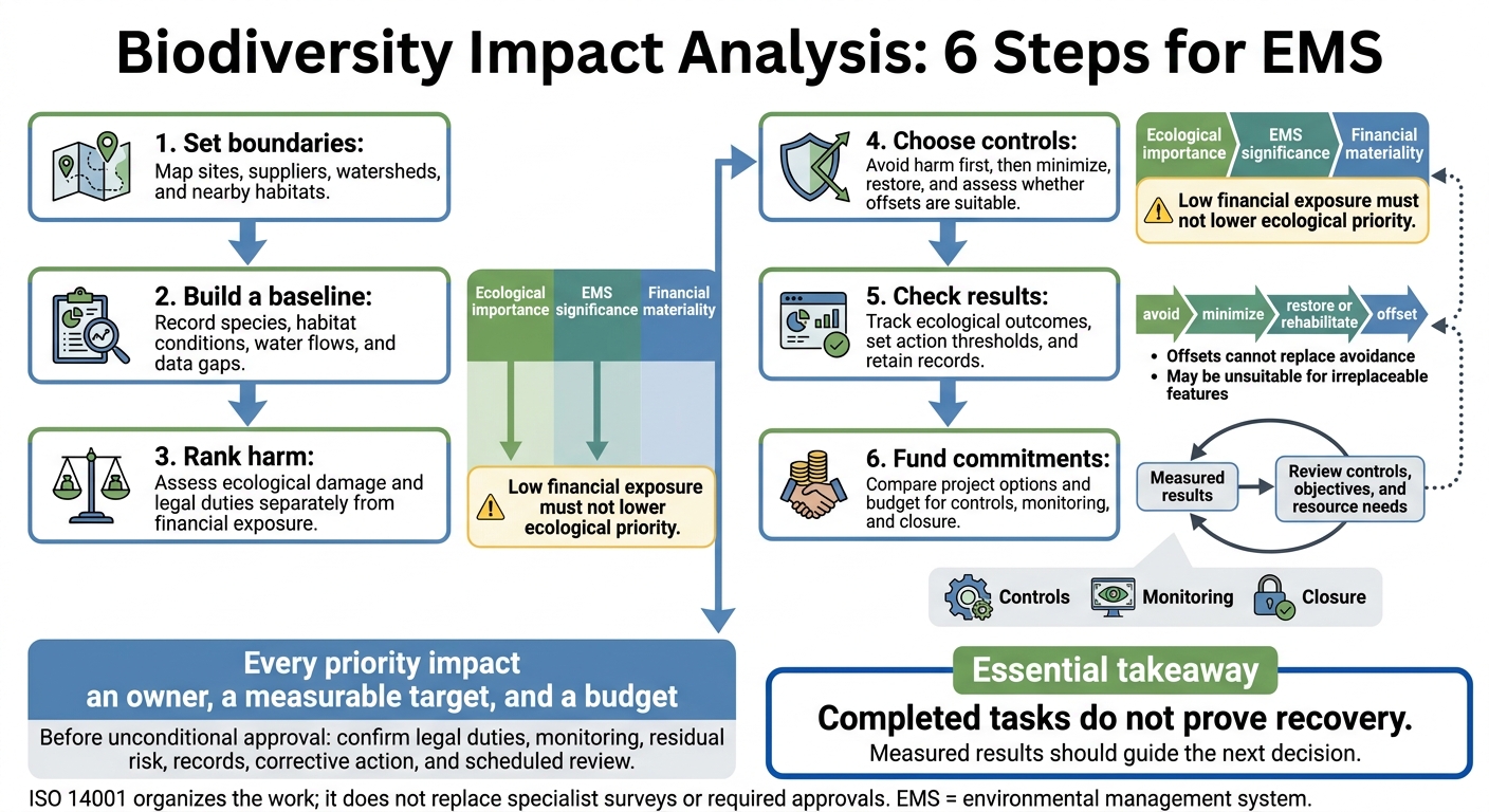
Biodiversity Impact Analysis: 6 Steps for EMS
ISO 14001:2026 - Understanding the New Edition of ISO 14001
sbb-itb-8baf5f1
Set Assessment Boundaries and Ecological Baselines
Once you’ve identified priority nature interfaces, set the study boundary and gather baseline evidence.
Map Sites, Suppliers, and Landscape Connections
Define organizational, geographic, life-cycle, and time boundaries before screening nature impacts. Cover controlled sites, projects, contractors, suppliers, transport routes, water withdrawals, and waste destinations. Look beyond property lines wherever runoff, groundwater, noise, light, or habitat fragmentation may affect nature. Account for seasonal cycles, construction, operation, closure, and cumulative pressures. Scale the assessment to ecological sensitivity and potential harm - not company size.[2][3]
Document the boundary so you can trace each impact to a location, pathway, and owner. Use the scope matrix below as a working template, and record map sources, dates, resolution, assumptions, and uncertainty alongside it. Treat unknown supplier origins as gaps, not low-risk locations. Request source coordinates and screen conservatively until those locations are verified.
| Activity or asset | Location and ecological setting | Impact pathway | Assessment scale | Data needed | Owner |
|---|---|---|---|---|---|
| Facility expansion | Parcel and watershed | Clearing, runoff, fragmentation | Parcel, watershed, landscape | Land cover, wetlands, species, drainage, permits | Project manager |
| Water withdrawal | River basin and downstream users | Reduced flow, temperature change | Watershed and seasonal flow regime | Withdrawal volume, flow records, ecological thresholds | Utilities manager |
| Agricultural supplier | Supplier farms and connected habitat | Pesticide runoff, soil loss, conversion | Supplier, catchment, landscape | Farm boundary, practices, riparian condition | Procurement lead |
| Freight route or waste contractor | Roads crossing wetlands, wildlife corridors, or disposal facilities | Collision, noise, contamination, disturbance | Route/corridor or receiving site | Route maps, crossing records, permits, release data | Logistics or EHS manager |
Screen Sensitive Areas and Legal Requirements
Before selecting locations, routes, designs, or sources, screen for protected lands, wetlands, listed-species ranges, critical habitat, wildlife corridors, and Tribal cultural or natural-resource areas. Start with USFWS IPaC, State Natural Heritage Programs, and State Wildlife Action Plans. Flag potential requirements under the Endangered Species Act (ESA), Clean Water Act Sections 401 and 404, stormwater rules, state endangered-species and wetland laws, local grading or tree-removal rules, and Tribal consultation processes. Assess whether NEPA applies when a federal action is involved.[4][5]
A blank map does not prove species absence, wetland jurisdiction, or compliance. Refer uncertain sites to qualified specialists and agencies.
Record Species, Habitats, and Ecosystem Services
Document conditions before disturbance: habitat extent and condition, species presence and seasonality, connectivity, invasive-species pressures, hydrology, and ecosystem services such as flood regulation, pollination, fisheries, and culturally important resources. Qualified ecologists should set survey methods and timing. One visit may miss migratory, cryptic, or dormant species.
Obtain consent before recording community or Tribal knowledge. Agree on permitted uses and limit access to sensitive location data.
Where IFC Performance Standard 6 applies, classify habitat as modified, natural, or critical using ecological evidence.[1][2] If natural or critical habitat may be present, assess an area larger than the parcel.[3] The baseline provides a reference for pressure mapping, thresholds, and controls. Use the register below to support later impact ratings and project decisions.
| Baseline field | What to record |
|---|---|
| Location and extent | Site, project, supplier, or landscape ID; coordinates; assessment boundary; map scale; and reporting area in acres, with hectares in parentheses where useful |
| Habitats and priority receptors | Habitat type, condition, connectivity, and classification as modified, natural, or potentially critical; species status, seasonality, and ecosystem-service values |
| Physical conditions and pressures | Hydrology, water quality, soil, land-use history, invasive species, existing disturbance, and cumulative pressures; label every measurement unit |
| Evidence and limitations | Sources, survey dates, methods, personnel, weather, detection limits, data confidence, assumptions, unresolved gaps, relevant permits, legal designations, agency correspondence, and Tribal or community inputs |
| Ownership and safeguards | Priority receptors, safeguards, owner, review date, escalation threshold, and data access limits |
Use this baseline in the next step to link activities to pressures and rank ecological harm.
Prioritize Biodiversity Impacts and Set EMS Controls
Use the baseline to rank each pressure, then turn the highest-risk items into EMS controls.
Map Activities, Pressures, and Ecological Effects
Build the register along a clear chain: activity → pressure → receptor/pathway → effect → impact → control. Include land conversion, fragmentation, extraction, pollution, water withdrawal, species introductions, disturbance, and climate stress.
Tag direct, indirect, induced, cumulative, and residual effects where relevant. For each entry, record the location, evidence source, owner, and confidence level. Assess cumulative pressures beyond the organization’s own contribution: a discharge that meets permit limits can still add nutrients to an already overloaded watershed.
Rate Ecological Harm and Business Materiality
Keep ecological importance, EMS significance, and financial materiality separate. Use defined rating scales, not a single blended score. Document receptor sensitivity; impact magnitude, extent, duration, reversibility, and likelihood; legal duties; stakeholder concerns; dependency criticality; and uncertainty.
Score financial exposure separately across cost, revenue, assets, supply continuity, liability, and financing. Low financial exposure must not lower ecological priority. Likewise, low greenhouse gas emissions do not mean low biodiversity impact.
Treat protected or irreplaceable features, possible species loss, irreversible harm, and legal noncompliance as automatic escalation triggers. Require qualified review before approving disturbance. When missing evidence could hide serious harm, use conservative assumptions and close the evidence gap before making an irreversible decision. Limited control over a supplier changes the response - not the impact’s significance.
With ecological and business priorities assessed separately, use the rankings to decide which impacts to avoid, reduce, restore, or offset.
Apply the Mitigation Hierarchy and Site Controls
Apply avoid → minimize → restore or rehabilitate → offset, in that order. Offsets cannot replace avoidance and may be unsuitable for irreplaceable features or those important to a community’s heritage or practices. Check any proposed offset for ecological equivalence, additionality, permanence, leakage, time lags, governance, monitoring, and verification in its specific setting.
Move high-priority impacts into control design and keep lower-priority items under routine monitoring. Turn each priority into an operating requirement that names the owner, location, timing, performance limit, monitoring method, and corrective-action trigger.
Build buffers, seasonal limits, withdrawal caps, biosecurity, contractor rules, training, and emergency response into procedures and work approvals. Assign one owner for each area: operations, design, procurement, legal review, finance, and EMS tracking.
Require change approval when footprints, suppliers, production, or permits change. Reassess after incidents, extreme weather, new species findings, or declining ecological indicators - even when no legal limit has been exceeded. Keep residual impacts open as a continuing EMS duty until monitoring shows recovery or residual risk is approved.
Set Biodiversity Targets and Keep EMS Records
Choose Outcome Metrics and Action Thresholds
Track outcomes, not inputs. Measure habitat function, native-species composition, wetland hydrology, species occupancy, corridor continuity, invasive cover, water quality, or wildlife mortality. Tie each metric to the control or restoration action it checks. Compare results against the baseline and, where feasible, reference or analogue sites. Acres restored alone do not prove recovery.[6][7][9]
Keep a target register that links each objective to supporting evidence and clear response rules:
| Register field | What to record |
|---|---|
| Scope and baseline | Linked impact, receptor, boundary, baseline reference, source, and confidence |
| Target and timing | Outcome metric, unit, target value, interim milestones, and target date |
| Monitoring plan | Sampling method, locations, season, frequency, duration, and responsible owner |
| Evidence and uncertainty | Required datasets, photographs, laboratory results, limitations, and triggers for additional sampling |
| Action threshold | Trigger value, immediate response, investigation owner, deadline, escalation route, and closure evidence |
Set thresholds before monitoring starts, covering both control failures and negative ecological trends. Act when occupancy declines, habitat condition falls, or milestones are missed - not just when the final target date arrives. Use qualified seasonal surveys and stronger sampling designs for high-risk receptors; periodic inspections may be enough for lower-risk areas. Account for seasonal variation and uncertainty before linking changes to an intervention.[8][9][11]
Use these targets and thresholds in capital planning to identify which actions need funding first, ensuring investments strengthen ecosystems and build long-term resilience.
Manage Records and Verify Results
Use the same records to check whether controls work, not just whether tasks are complete. Retain maps, GIS layers, surveys, permits, impact registers, raw data and validated datasets, inspections, incidents, restoration results, and management decisions. Assign record owners and set rules for version control, source metadata, retention periods, access rights, backups, and GIS update approvals. Restrict access to sensitive species locations, and keep equipment maintenance and calibration records where relevant.[7][9][10][12]
Use site inspections to check conditions and internal audits to test whether controls, data, and assumptions hold up in practice. Have qualified ecological reviewers assess methods and results, with independent review for high-risk cases. Treat missed surveys, unreliable data, and unsupported recovery claims as nonconformities. Before closing each one, record its root cause, owner, deadline, corrective action, and effectiveness check. Management review should use these findings to revise controls, objectives, and resource needs - not equate completed tasks with success.[7][9][10]
Bring Biodiversity Findings into Capital Planning
Carry every priority impact from the target register into the funding memo. Put biodiversity requirements in the funding memo - not just the environmental report. Document site constraints, affected receptors, design conditions, permit duties, mitigation costs, residual impacts, and the decision owner. Explain how each affects project viability, permits, schedule, and the funding recommendation so biodiversity stays part of capital approval.
Compare Project Options Before Funding
Screen options during site selection, concept design, procurement, and final approval. Compare them on the same financial basis, apply a consistent scoring method, and state assumptions openly. Don’t treat the preferred option as a foregone conclusion.
Use project-specific USD estimates, separating capital costs from annual operating costs. Include a realistic no-project case that accounts for pressures from continued operations.
| Option to assess | Biodiversity effects | Mitigation costs in USD | Life-cycle costs | Permit and schedule exposure | Resilience benefits | Residual risk | Approval decision |
|---|---|---|---|---|---|---|---|
| Proposed site and design | Identify affected species, habitats, and connectivity | Price controls and monitoring | Include operations, restoration, and closure | Identify permits and seasonal restrictions | Assess water security and flood control | Quantify impacts remaining after controls | Approve; approve with conditions; defer pending data; redesign; or reject |
| Alternative site or footprint | Identify impacts avoided and new pressures | Price redesign and remaining controls | Compare on the same financial basis | Assess changes to approvals and construction timing | Compare ecosystem-service dependencies | Assess remaining harm and uncertainty | Select only after comparison |
| No-project case, where realistic | Avoid new disturbance while retaining current pressures | Include existing control obligations | Include continued operations and liabilities | Identify continuing permit duties | Assess retained ecosystem services | Record unresolved existing risks | Defer or manage existing controls |
Test reduced water availability, ecological decline, and changing land-use constraints. For each scenario, record the trigger, probability or range, financial consequence, mitigation response, and decision threshold. A higher risk score alone isn’t enough.
Set Budgets, Owners, and Approval Gates
Assign capital and operating budgets for redesign, water treatment, wildlife crossings, restoration, monitoring, invasive-species control, and closure. Give every commitment an owner and budget code.
Require EMS and finance sign-off at concept, design, permit, funding, construction, operations, closure, and expansion gates. Funding papers should state cost ranges, survey gaps, residual impacts, assumptions, and uncertainty, plus the conditions for releasing funds.
Conclusion: Fund and Review Biodiversity Actions
Before unconditional approval, confirm that every priority impact has:
An accountable owner, a mitigation-hierarchy control[2], and a linked target-register entry.
An approved monitoring budget and schedule, plus documented permit, consultation, or legal duties.
Capital and operating budgets that include contingency and closure costs.
An assessment of assumptions, uncertainty, and residual risk.
A record-retention location and evidence standard.
A corrective-action and escalation process.
A scheduled EMS, finance, and management review.
FAQs
How often should I update my biodiversity assessment?
Conduct field audits quarterly or annually, depending on your facility and its activities, to track changes in species, habitats, and ecosystem health. Report the same core metrics year over year to keep consistent oversight of complex, site-specific biodiversity data.
Adjust management strategies as seasons shift, industrial activities change, and climate conditions evolve. Use monitoring results to refine your biodiversity action plan and keep it aligned with long-term sustainability goals.
How can I distinguish project impacts from natural changes?
Before development begins, establish a baseline with ecological surveys that record species, habitat conditions, and ecosystem health. Track changes through periodic field audits, monitoring, and remote sensing, such as satellite imagery or drone surveys.
Compare new data against that baseline, accounting for seasonal shifts and broader climate trends. This helps separate the effects of your industrial activities from natural changes and outside environmental factors.
How should I prioritize biodiversity actions with limited funding?
Focus on areas with the greatest impact and material risk. Use the Science Based Targets Network (SBTN) framework to screen your value chain and map impacts by location. Follow the mitigation hierarchy: avoid, minimize, restore, then offset. Never skip avoidance or minimization.
Make funding go further with nature-based solutions that deliver multiple benefits and targeted investments at wildlife corridor pinch points. Consider blended finance, green bonds, or government grants to supplement internal capital.



FAQ