

Jan 23, 2026
How to Integrate Climate Risk into Infrastructure Planning for Foundations & Philanthropic Organizations
Sustainability Strategy
In This Article
Step-by-step guide for foundations to assess climate hazards, prioritize vulnerable assets, adopt adaptation measures, and monitor resilience using federal tools.
How to Integrate Climate Risk into Infrastructure Planning for Foundations & Philanthropic Organizations
Climate risks like extreme heat, flooding, and wildfires are reshaping infrastructure planning for foundations and philanthropic organizations. Ignoring these risks can lead to costly disruptions and jeopardize critical community assets.
Key Takeaways:
Why it matters: Climate risks impact essential infrastructure like healthcare centers, schools, and water systems. Rising sea levels, shifting weather patterns, and frequent hazards demand forward-thinking strategies.
What to do: Use tools like FEMA’s National Risk Index, NOAA’s Climate Explorer, and the U.S. Climate Resilience Toolkit to gather climate data and assess risks.
How to act: Conduct climate risk assessments using frameworks like the PIEVC Protocol, prioritize high-risk assets, and implement targeted resilience measures.
Stay proactive: Establish monitoring systems to track effectiveness and adjust plans as climate conditions evolve.
By integrating climate risk into planning, organizations can protect investments, ensure infrastructure longevity, and support the communities they serve.
5-Step Climate Risk Integration Framework for Infrastructure Planning
Top Climate Resilient Infrastructure Solutions for Civil Engineers
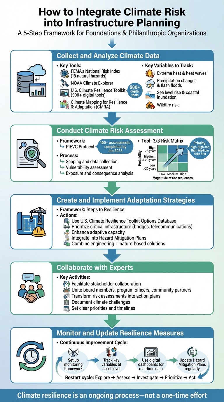
Step 1: Collect and Analyze Climate Data
Accurate climate data is the foundation of effective resilience planning. Without dependable information, any strategy risks falling short. Thankfully, U.S. government agencies and scientific institutions provide tools to help organizations access the data they need. Here's a look at where to find this data and how to use it to inform your analysis.
Where to Find Climate Data
The Fifth National Climate Assessment (NCA5), published in 2023 by the U.S. Global Change Research Program[7], serves as a key resource for climate-related decision-making across the nation. Additional tools like the Climate Mapping for Resilience & Adaptation (CMRA) portal and the U.S. Climate Resilience Toolkit compile a wide range of federal and non-federal datasets. These resources document historical, current, and projected climate hazards, offering access to over 500 digital tools, including the "Steps to Resilience" framework, which is particularly useful for systematic infrastructure planning[1][3][8].
For broader initial assessments, FEMA's National Risk Index provides an interactive mapping tool that compares data for 18 natural hazards at the community level[4]. If you need localized projections, the NOAA Climate Explorer offers visualizations of expected changes in temperature and precipitation patterns[3]. For more specific concerns, tools like the NOAA Sea Level Rise Viewer are invaluable for coastal planning, while the "Wildfire Risk to Communities" tool helps address fire-prone areas[3].
Which Climate Variables to Track
To protect infrastructure effectively, focus on the climate factors that pose direct threats to its integrity. For instance:
Extreme heat, including heat waves lasting two or more days, can overburden energy systems and weaken building materials[6].
Precipitation changes may lead to droughts or flash floods, with flash floods defined as rapid water flow occurring within six hours of intense rainfall[6].
Sea level rise and coastal inundation endanger facilities near shorelines.
Wildfire risk intensifies as conditions become hotter and drier[6][1].
The CMRA Assessment Tool is a good starting point to evaluate how these hazards are expected to evolve over time[1]. For drought resilience, analyzing water usage at the building level can highlight areas for conservation[6]. When planning for flood resilience, consider increasing local freeboard requirements to at least four feet above the base flood level for public facilities[6]. By defining these variables, you can identify the specific risks that may impact your project site.
Evaluate Location-Specific Risks
Once you've gathered and analyzed the data, the next step is to assess how these metrics shape local risk profiles. Every project site has its own mix of vulnerabilities based on its geographic and environmental context. FEMA's National Risk Index is an excellent tool for identifying assets that are most at risk[4]. As the U.S. Climate Resilience Toolkit explains:
Risk is a compound concept that describes the chance of sustaining a substantial loss. The first element of risk is the probability of a hazard occurring. The second element is the magnitude of consequences from the event. - U.S. Climate Resilience Toolkit[4]
To visualize these risks, use a 3x3 risk matrix to map assets based on likelihood (y-axis) and the magnitude of consequences (x-axis)[4]. For example, hazards expected within five years might be labeled as "high probability", while those anticipated once every 20 years or more could be considered "low probability"[4]. For more complex assessments involving multiple types of infrastructure, it may be helpful to consult Architecture and Engineering firms or adaptation specialists who can interpret technical climate data and provide actionable recommendations[4].
Step 2: Conduct a Climate Risk Assessment
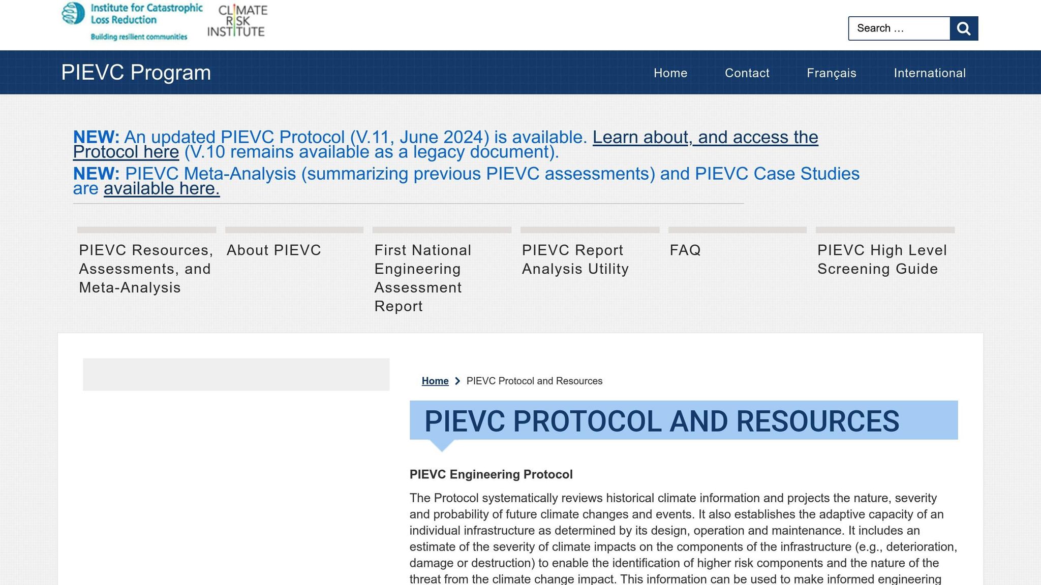
Once you've gathered climate data, the next step is to turn that information into actionable strategies. The PIEVC Protocol provides a structured framework to guide this process. By January 2023, this protocol had been used to complete over 100 infrastructure risk assessments across a wide range of systems, including residential and commercial buildings, stormwater and wastewater systems, roads, bridges, water supply networks, and even airport infrastructure [12]. Its applications are not limited to Canada; it has also been employed in countries like Costa Rica, Honduras, Brazil, Vietnam, and regions such as the Nile River Basin [10]. This approach lays the groundwork for integrating the PIEVC Protocol into your own risk assessment.
Applying the PIEVC Protocol
The PIEVC Protocol is a five-step process designed to evaluate how climate impacts infrastructure. It starts with scoping and data collection, where you define the scope of your assessment and identify the assets at risk. Next, conduct a vulnerability assessment, which examines two key factors: sensitivity (how prone an asset is to damage) and adaptive capacity (its ability to adapt or recover). Follow this with an exposure and consequence analysis to estimate the potential damage or degradation of specific infrastructure components [4][9][12].
In June 2024, an updated version of the protocol, PIEVC Protocol V.11, was released, offering refined methods and tools [11]. For those conducting initial assessments, the PIEVC High Level Screening Guide provides a quick way to pinpoint assets that may require deeper analysis [11].
Scoring Risks and Setting Priorities
After completing the vulnerability assessment, use a 3x3 risk matrix to prioritize resources effectively. This matrix plots each asset-hazard pair on a grid, with probability on the vertical axis and magnitude of consequence on the horizontal axis [4][9]. To maintain consistency, categorize hazards based on timeframes: those expected within five years as "High", those in 5–20 years as "Medium", and those beyond 20 years as "Low" [4][9].
Immediate attention should go to assets that fall into the "High-High" or "High-Medium" sections of the matrix, as these pose the greatest risk of significant loss [4]. Additionally, prioritize assets with the potential to cause cascading failures - such as critical bridges or telecommunications hubs - even if their individual risk scores are not the highest [4][9]. This ensures a comprehensive approach to safeguarding infrastructure against climate risks.
Step 3: Create and Implement Adaptation Strategies
Use the Steps to Resilience framework to develop and apply specific measures that address the climate hazards you've identified - whether it's erosion, extreme heat, flooding, landslides, or severe winter weather [5][1]. This framework helps you prioritize and implement solutions effectively, ensuring your strategies are closely aligned with the risks at hand [13].
For tailored solutions, explore the U.S. Climate Resilience Toolkit's Options Database, which offers both engineering and nature-based approaches to manage specific climate risks [1][3]. Pay particular attention to critical infrastructure that could lead to cascading failures across various sectors. As highlighted in the U.S. Climate Resilience Toolkit:
If you recognize that damage to a specific asset (for example, a heavily used bridge or your telecommunications capacity) could initiate multiple failures across other sectors in your community, consider that asset as a top priority [4].
Adaptation Approaches for Infrastructure
Using your risk assessment as a guide, craft adaptation strategies that address identified hazards while aligning with community priorities [4]. Many organizations bring in Architecture and Engineering (A&E) firms or climate adaptation specialists to tackle complex technical requirements and ensure solutions reflect their broader mission [4]. These strategies might include upgrading design standards to meet future climate challenges or adopting nature-based solutions like green infrastructure.
For assets particularly vulnerable to climate impacts, focus on enhancing their adaptive capacity - their ability to adjust to potential damage or recover quickly [4]. While qualitative assessments can guide early planning stages, incorporating quantitative geospatial data and property valuations is crucial when seeking approval for substantial infrastructure investments. This data-driven approach minimizes uncertainty and strengthens the case for resilience-focused budgets [4].
Build Climate Resilience into Design
To secure federal and state funding, integrate your adaptation strategies into official planning documents like Hazard Mitigation Plans [5]. Conduct stress tests that simulate multiple future scenarios to ensure your infrastructure remains functional even under unexpected climate conditions.
The U.S. Climate Resilience Toolkit underscores the importance of combining data with community input:
Leveraging community engagements... to add climate considerations to planning documents is an efficient way to move plans forward and integrate climate resilience into future plans [5].
Step 4: Work with Council Fire for Climate Resilience Planning
Once your risk assessment is complete, the next step is to collaborate with climate experts who can simplify resilience planning while aligning with your foundation's goals. Council Fire offers extensive experience in climate science and risk management, helping foundations document climate-related hazards and create customized climate action plans [5]. This stage transforms your data-driven insights into actionable, collaborative strategies.
Facilitate Stakeholder Collaboration
Successful climate resilience planning hinges on uniting a variety of perspectives, from board members and program officers to community partners and technical experts. Council Fire fosters this collaboration by organizing stakeholder groups that delve into local climate issues and focus on safeguarding the assets your foundation values most [5]. The process starts with gathering key community members and planners to align technical priorities with social needs. By merging data analysis with participatory approaches, Council Fire guides you from identifying hazards to implementing structured resilience plans.
Turn Climate Risk Assessments into Action
Using your established risk matrix and assessment protocols as a foundation, Council Fire ensures that your findings translate into tangible infrastructure adaptations. Through the Steps to Resilience process, Council Fire transforms risk assessments into practical strategies [5]. Rather than creating reports that remain unused, they help you identify which asset–hazard combinations require immediate action and which adaptation measures will have the most significant impact.
Their support includes breaking down complex climate data, documenting critical challenges, and setting clear priorities for intricate infrastructure systems [4]. Whether you need rapid qualitative screenings or detailed geospatial analyses, Council Fire customizes its approach to fit your needs and resources [4][9]. This results in a well-defined roadmap that connects climate data to actionable design standards, funding opportunities, and implementation timelines.
Step 5: Monitor and Update Resilience Measures
As climate conditions continue to shift, your resilience strategies must keep pace. Once adaptation measures are in place, it's essential to establish a structured monitoring framework to track their effectiveness and refine your approach as needed. Building resilience is not a one-time effort - it’s an ongoing process of assessing exposure, vulnerability, and risk in response to evolving climate patterns [5].
Set Up a Monitoring Framework
To effectively monitor climate-related risks, implement systems that track key variables at the asset level. For example, in water-related infrastructure, monitoring water usage trends can help identify early signs of potential issues like drought [6]. Digital tools, such as dashboards, can provide real-time data, reveal emerging trends, and pinpoint vulnerabilities [6].
While qualitative assessments can offer an initial understanding, transitioning to quantitative tools, such as geospatial data and mapping layers, reduces uncertainty and enhances accuracy [4]. Establish clear and consistent criteria for categorizing hazards - for instance, defining "high probability" as an event likely to occur within the next five years. This ensures that your data is applied uniformly over time [4].
Incorporate climate resilience monitoring into your routine administrative processes. For instance, updates to official planning documents, like Hazard Mitigation Plans, can serve as structured opportunities to reassess and refine your strategies [5]. Using these mandated updates for federal and state program compliance offers a practical timeline for evaluating progress. Collaboration is key - local leaders, climate-service practitioners, and other stakeholders should work together to document hazards and manage the resilience process [5]. This cycle of monitoring and adjustment helps ensure continuous improvement.
Apply Continuous Improvement
The "Steps to Resilience" framework operates as a dynamic, five-step cycle: Explore Hazards, Assess Vulnerability and Risk, Investigate Options, Prioritize and Plan, and Take Action [5][1]. Monitoring plays a crucial role in restarting this cycle by providing updated data for the "Explore Hazards" phase. By analyzing hazard frequency data and aligning with required update timelines, you can refine future climate plans and strategies [4][5].
Keep an eye on resources and datasets from organizations like the Federal Highway Administration and NOAA, as these are regularly updated with new insights and tools [2]. When necessary, bring in adaptation experts to document new climate challenges and ensure your strategies remain effective [4].
Conclusion
Key Takeaways
Incorporating climate risk into infrastructure planning is essential for safeguarding investments and ensuring long-term success. The approach involves several key steps: gathering reliable climate data from tools like the Climate Mapping for Resilience & Adaptation (CMRA) Assessment Tool, conducting thorough risk assessments, crafting adaptation strategies tailored to specific assets, and implementing monitoring systems to track performance over time.
A well-rounded strategy blends qualitative screening with quantitative analysis. Risk assessments should guide prioritization, especially for critical assets where failure could lead to broader disruptions, such as telecommunications networks or essential bridges [4][9]. Resilience-building isn’t a one-and-done effort - it requires ongoing evaluation and the integration of findings into official planning documents to qualify for federal and state support programs [5]. These steps create a robust framework for managing climate risks while delivering environmental, social, and economic benefits.
With these principles in mind, the next steps outline actionable ways to embed resilience into your planning efforts.
Next Steps
Start by forming a resilience team, led by a local advocate, to coordinate stakeholders and guide the planning process [5]. Conduct an inventory of critical assets and perform an initial screening to identify vulnerabilities. For organizations new to climate planning, the six-module "Steps to Resilience" e-learning course provides practical tools to build internal expertise [5].
Council Fire can help turn your risk assessments into actionable resilience plans. By fostering collaboration among stakeholders and applying systems thinking, we bring the strategies discussed here to life - ensuring your infrastructure projects are prepared for the future. Whether it’s vulnerability screening, developing adaptation strategies, or setting up ongoing monitoring systems, our team offers the technical know-how and strategic communication skills needed to protect your investments and achieve lasting results.
FAQs
How can philanthropic organizations prioritize infrastructure projects while addressing climate risks?
Philanthropic organizations can effectively address climate-related challenges by focusing on their most vulnerable infrastructure assets. Start by identifying which assets face the greatest risks from events like floods, extreme heat, or storms. Evaluate how sensitive these assets are to such hazards and consider their capacity to withstand or adapt to these threats.
Once you've pinpointed the key vulnerabilities, prioritize solutions that deliver the most meaningful resilience benefits. Carefully weigh the costs, potential benefits, and practicality of each option. Develop a targeted plan that addresses the most pressing projects first. It's also crucial to revisit and update these assessments regularly, incorporating the latest climate data and forecasts to ensure your strategies stay relevant and responsive to changing risks and community priorities.
By adopting a forward-thinking, data-informed approach, organizations can make well-placed investments that reduce climate risks while fostering long-term resilience and adaptability.
What tools can help assess climate risks for specific locations?
To evaluate climate risks for specific areas, leveraging a mix of mapping tools and risk assessment resources proves invaluable. Platforms like the Climate Mapping for Resilience and Adaptation (CMRA) offer detailed maps and localized data, making it easier to pinpoint hazards such as flooding, wildfires, or rising sea levels. Similarly, the Sea Level Rise Viewer helps visualize how coastal regions might be affected by increasing sea levels, supporting more focused risk evaluations.
For a broader perspective, tools like the EPA's climate risk assessment worksheets assist organizations in identifying vulnerabilities and selecting the most relevant data for their needs. Federal agencies also recommend using localized climate scenarios and downscaled data to produce precise and actionable insights. Together, these resources empower organizations to develop resilience strategies tailored to their specific locations and operational needs.
How can foundations and philanthropic organizations maintain and update climate resilience strategies in their infrastructure planning?
Keeping climate resilience strategies effective calls for an ongoing, proactive effort. Begin with regular vulnerability assessments to pinpoint which assets are at risk from climate-related threats. These evaluations should also gauge the ability of these assets to adapt. It's essential to revisit and update these assessments frequently to reflect the latest climate data, emerging risks, and any shifts in community needs or infrastructure conditions.
Integrating climate forecasting tools and scenario planning into your decision-making process is another crucial step. These tools help organizations anticipate potential risks and develop adaptable, durable infrastructure. Alongside this, implement monitoring systems with clearly defined performance indicators to track how well resilience measures are working over time. By following this cycle of assessment, action, and review, organizations can ensure their strategies stay effective and aligned with the ever-changing climate landscape.
Related Blog Posts
How to Build a Climate Resilience Plan for Foundations & Philanthropic Organizations
How to Integrate Climate Risk into Infrastructure Planning for Corporations
How to Integrate Climate Risk into Infrastructure Planning for Municipalities & Government Agencies
How to Integrate Climate Risk into Infrastructure Planning for NGOs & Nonprofits
Latest Articles
©2025


FAQ
01
What does it really mean to “redefine profit”?
02
What makes Council Fire different?
03
Who does Council Fire you work with?
04
What does working with Council Fire actually look like?
05
How does Council Fire help organizations turn big goals into action?
06
How does Council Fire define and measure success?
Jan 23, 2026
How to Integrate Climate Risk into Infrastructure Planning for Foundations & Philanthropic Organizations
Sustainability Strategy
In This Article
Step-by-step guide for foundations to assess climate hazards, prioritize vulnerable assets, adopt adaptation measures, and monitor resilience using federal tools.
How to Integrate Climate Risk into Infrastructure Planning for Foundations & Philanthropic Organizations
Climate risks like extreme heat, flooding, and wildfires are reshaping infrastructure planning for foundations and philanthropic organizations. Ignoring these risks can lead to costly disruptions and jeopardize critical community assets.
Key Takeaways:
Why it matters: Climate risks impact essential infrastructure like healthcare centers, schools, and water systems. Rising sea levels, shifting weather patterns, and frequent hazards demand forward-thinking strategies.
What to do: Use tools like FEMA’s National Risk Index, NOAA’s Climate Explorer, and the U.S. Climate Resilience Toolkit to gather climate data and assess risks.
How to act: Conduct climate risk assessments using frameworks like the PIEVC Protocol, prioritize high-risk assets, and implement targeted resilience measures.
Stay proactive: Establish monitoring systems to track effectiveness and adjust plans as climate conditions evolve.
By integrating climate risk into planning, organizations can protect investments, ensure infrastructure longevity, and support the communities they serve.
5-Step Climate Risk Integration Framework for Infrastructure Planning
Top Climate Resilient Infrastructure Solutions for Civil Engineers
Step 1: Collect and Analyze Climate Data
Accurate climate data is the foundation of effective resilience planning. Without dependable information, any strategy risks falling short. Thankfully, U.S. government agencies and scientific institutions provide tools to help organizations access the data they need. Here's a look at where to find this data and how to use it to inform your analysis.
Where to Find Climate Data
The Fifth National Climate Assessment (NCA5), published in 2023 by the U.S. Global Change Research Program[7], serves as a key resource for climate-related decision-making across the nation. Additional tools like the Climate Mapping for Resilience & Adaptation (CMRA) portal and the U.S. Climate Resilience Toolkit compile a wide range of federal and non-federal datasets. These resources document historical, current, and projected climate hazards, offering access to over 500 digital tools, including the "Steps to Resilience" framework, which is particularly useful for systematic infrastructure planning[1][3][8].
For broader initial assessments, FEMA's National Risk Index provides an interactive mapping tool that compares data for 18 natural hazards at the community level[4]. If you need localized projections, the NOAA Climate Explorer offers visualizations of expected changes in temperature and precipitation patterns[3]. For more specific concerns, tools like the NOAA Sea Level Rise Viewer are invaluable for coastal planning, while the "Wildfire Risk to Communities" tool helps address fire-prone areas[3].
Which Climate Variables to Track
To protect infrastructure effectively, focus on the climate factors that pose direct threats to its integrity. For instance:
Extreme heat, including heat waves lasting two or more days, can overburden energy systems and weaken building materials[6].
Precipitation changes may lead to droughts or flash floods, with flash floods defined as rapid water flow occurring within six hours of intense rainfall[6].
Sea level rise and coastal inundation endanger facilities near shorelines.
Wildfire risk intensifies as conditions become hotter and drier[6][1].
The CMRA Assessment Tool is a good starting point to evaluate how these hazards are expected to evolve over time[1]. For drought resilience, analyzing water usage at the building level can highlight areas for conservation[6]. When planning for flood resilience, consider increasing local freeboard requirements to at least four feet above the base flood level for public facilities[6]. By defining these variables, you can identify the specific risks that may impact your project site.
Evaluate Location-Specific Risks
Once you've gathered and analyzed the data, the next step is to assess how these metrics shape local risk profiles. Every project site has its own mix of vulnerabilities based on its geographic and environmental context. FEMA's National Risk Index is an excellent tool for identifying assets that are most at risk[4]. As the U.S. Climate Resilience Toolkit explains:
Risk is a compound concept that describes the chance of sustaining a substantial loss. The first element of risk is the probability of a hazard occurring. The second element is the magnitude of consequences from the event. - U.S. Climate Resilience Toolkit[4]
To visualize these risks, use a 3x3 risk matrix to map assets based on likelihood (y-axis) and the magnitude of consequences (x-axis)[4]. For example, hazards expected within five years might be labeled as "high probability", while those anticipated once every 20 years or more could be considered "low probability"[4]. For more complex assessments involving multiple types of infrastructure, it may be helpful to consult Architecture and Engineering firms or adaptation specialists who can interpret technical climate data and provide actionable recommendations[4].
Step 2: Conduct a Climate Risk Assessment
Once you've gathered climate data, the next step is to turn that information into actionable strategies. The PIEVC Protocol provides a structured framework to guide this process. By January 2023, this protocol had been used to complete over 100 infrastructure risk assessments across a wide range of systems, including residential and commercial buildings, stormwater and wastewater systems, roads, bridges, water supply networks, and even airport infrastructure [12]. Its applications are not limited to Canada; it has also been employed in countries like Costa Rica, Honduras, Brazil, Vietnam, and regions such as the Nile River Basin [10]. This approach lays the groundwork for integrating the PIEVC Protocol into your own risk assessment.
Applying the PIEVC Protocol
The PIEVC Protocol is a five-step process designed to evaluate how climate impacts infrastructure. It starts with scoping and data collection, where you define the scope of your assessment and identify the assets at risk. Next, conduct a vulnerability assessment, which examines two key factors: sensitivity (how prone an asset is to damage) and adaptive capacity (its ability to adapt or recover). Follow this with an exposure and consequence analysis to estimate the potential damage or degradation of specific infrastructure components [4][9][12].
In June 2024, an updated version of the protocol, PIEVC Protocol V.11, was released, offering refined methods and tools [11]. For those conducting initial assessments, the PIEVC High Level Screening Guide provides a quick way to pinpoint assets that may require deeper analysis [11].
Scoring Risks and Setting Priorities
After completing the vulnerability assessment, use a 3x3 risk matrix to prioritize resources effectively. This matrix plots each asset-hazard pair on a grid, with probability on the vertical axis and magnitude of consequence on the horizontal axis [4][9]. To maintain consistency, categorize hazards based on timeframes: those expected within five years as "High", those in 5–20 years as "Medium", and those beyond 20 years as "Low" [4][9].
Immediate attention should go to assets that fall into the "High-High" or "High-Medium" sections of the matrix, as these pose the greatest risk of significant loss [4]. Additionally, prioritize assets with the potential to cause cascading failures - such as critical bridges or telecommunications hubs - even if their individual risk scores are not the highest [4][9]. This ensures a comprehensive approach to safeguarding infrastructure against climate risks.
Step 3: Create and Implement Adaptation Strategies
Use the Steps to Resilience framework to develop and apply specific measures that address the climate hazards you've identified - whether it's erosion, extreme heat, flooding, landslides, or severe winter weather [5][1]. This framework helps you prioritize and implement solutions effectively, ensuring your strategies are closely aligned with the risks at hand [13].
For tailored solutions, explore the U.S. Climate Resilience Toolkit's Options Database, which offers both engineering and nature-based approaches to manage specific climate risks [1][3]. Pay particular attention to critical infrastructure that could lead to cascading failures across various sectors. As highlighted in the U.S. Climate Resilience Toolkit:
If you recognize that damage to a specific asset (for example, a heavily used bridge or your telecommunications capacity) could initiate multiple failures across other sectors in your community, consider that asset as a top priority [4].
Adaptation Approaches for Infrastructure
Using your risk assessment as a guide, craft adaptation strategies that address identified hazards while aligning with community priorities [4]. Many organizations bring in Architecture and Engineering (A&E) firms or climate adaptation specialists to tackle complex technical requirements and ensure solutions reflect their broader mission [4]. These strategies might include upgrading design standards to meet future climate challenges or adopting nature-based solutions like green infrastructure.
For assets particularly vulnerable to climate impacts, focus on enhancing their adaptive capacity - their ability to adjust to potential damage or recover quickly [4]. While qualitative assessments can guide early planning stages, incorporating quantitative geospatial data and property valuations is crucial when seeking approval for substantial infrastructure investments. This data-driven approach minimizes uncertainty and strengthens the case for resilience-focused budgets [4].
Build Climate Resilience into Design
To secure federal and state funding, integrate your adaptation strategies into official planning documents like Hazard Mitigation Plans [5]. Conduct stress tests that simulate multiple future scenarios to ensure your infrastructure remains functional even under unexpected climate conditions.
The U.S. Climate Resilience Toolkit underscores the importance of combining data with community input:
Leveraging community engagements... to add climate considerations to planning documents is an efficient way to move plans forward and integrate climate resilience into future plans [5].
Step 4: Work with Council Fire for Climate Resilience Planning
Once your risk assessment is complete, the next step is to collaborate with climate experts who can simplify resilience planning while aligning with your foundation's goals. Council Fire offers extensive experience in climate science and risk management, helping foundations document climate-related hazards and create customized climate action plans [5]. This stage transforms your data-driven insights into actionable, collaborative strategies.
Facilitate Stakeholder Collaboration
Successful climate resilience planning hinges on uniting a variety of perspectives, from board members and program officers to community partners and technical experts. Council Fire fosters this collaboration by organizing stakeholder groups that delve into local climate issues and focus on safeguarding the assets your foundation values most [5]. The process starts with gathering key community members and planners to align technical priorities with social needs. By merging data analysis with participatory approaches, Council Fire guides you from identifying hazards to implementing structured resilience plans.
Turn Climate Risk Assessments into Action
Using your established risk matrix and assessment protocols as a foundation, Council Fire ensures that your findings translate into tangible infrastructure adaptations. Through the Steps to Resilience process, Council Fire transforms risk assessments into practical strategies [5]. Rather than creating reports that remain unused, they help you identify which asset–hazard combinations require immediate action and which adaptation measures will have the most significant impact.
Their support includes breaking down complex climate data, documenting critical challenges, and setting clear priorities for intricate infrastructure systems [4]. Whether you need rapid qualitative screenings or detailed geospatial analyses, Council Fire customizes its approach to fit your needs and resources [4][9]. This results in a well-defined roadmap that connects climate data to actionable design standards, funding opportunities, and implementation timelines.
Step 5: Monitor and Update Resilience Measures
As climate conditions continue to shift, your resilience strategies must keep pace. Once adaptation measures are in place, it's essential to establish a structured monitoring framework to track their effectiveness and refine your approach as needed. Building resilience is not a one-time effort - it’s an ongoing process of assessing exposure, vulnerability, and risk in response to evolving climate patterns [5].
Set Up a Monitoring Framework
To effectively monitor climate-related risks, implement systems that track key variables at the asset level. For example, in water-related infrastructure, monitoring water usage trends can help identify early signs of potential issues like drought [6]. Digital tools, such as dashboards, can provide real-time data, reveal emerging trends, and pinpoint vulnerabilities [6].
While qualitative assessments can offer an initial understanding, transitioning to quantitative tools, such as geospatial data and mapping layers, reduces uncertainty and enhances accuracy [4]. Establish clear and consistent criteria for categorizing hazards - for instance, defining "high probability" as an event likely to occur within the next five years. This ensures that your data is applied uniformly over time [4].
Incorporate climate resilience monitoring into your routine administrative processes. For instance, updates to official planning documents, like Hazard Mitigation Plans, can serve as structured opportunities to reassess and refine your strategies [5]. Using these mandated updates for federal and state program compliance offers a practical timeline for evaluating progress. Collaboration is key - local leaders, climate-service practitioners, and other stakeholders should work together to document hazards and manage the resilience process [5]. This cycle of monitoring and adjustment helps ensure continuous improvement.
Apply Continuous Improvement
The "Steps to Resilience" framework operates as a dynamic, five-step cycle: Explore Hazards, Assess Vulnerability and Risk, Investigate Options, Prioritize and Plan, and Take Action [5][1]. Monitoring plays a crucial role in restarting this cycle by providing updated data for the "Explore Hazards" phase. By analyzing hazard frequency data and aligning with required update timelines, you can refine future climate plans and strategies [4][5].
Keep an eye on resources and datasets from organizations like the Federal Highway Administration and NOAA, as these are regularly updated with new insights and tools [2]. When necessary, bring in adaptation experts to document new climate challenges and ensure your strategies remain effective [4].
Conclusion
Key Takeaways
Incorporating climate risk into infrastructure planning is essential for safeguarding investments and ensuring long-term success. The approach involves several key steps: gathering reliable climate data from tools like the Climate Mapping for Resilience & Adaptation (CMRA) Assessment Tool, conducting thorough risk assessments, crafting adaptation strategies tailored to specific assets, and implementing monitoring systems to track performance over time.
A well-rounded strategy blends qualitative screening with quantitative analysis. Risk assessments should guide prioritization, especially for critical assets where failure could lead to broader disruptions, such as telecommunications networks or essential bridges [4][9]. Resilience-building isn’t a one-and-done effort - it requires ongoing evaluation and the integration of findings into official planning documents to qualify for federal and state support programs [5]. These steps create a robust framework for managing climate risks while delivering environmental, social, and economic benefits.
With these principles in mind, the next steps outline actionable ways to embed resilience into your planning efforts.
Next Steps
Start by forming a resilience team, led by a local advocate, to coordinate stakeholders and guide the planning process [5]. Conduct an inventory of critical assets and perform an initial screening to identify vulnerabilities. For organizations new to climate planning, the six-module "Steps to Resilience" e-learning course provides practical tools to build internal expertise [5].
Council Fire can help turn your risk assessments into actionable resilience plans. By fostering collaboration among stakeholders and applying systems thinking, we bring the strategies discussed here to life - ensuring your infrastructure projects are prepared for the future. Whether it’s vulnerability screening, developing adaptation strategies, or setting up ongoing monitoring systems, our team offers the technical know-how and strategic communication skills needed to protect your investments and achieve lasting results.
FAQs
How can philanthropic organizations prioritize infrastructure projects while addressing climate risks?
Philanthropic organizations can effectively address climate-related challenges by focusing on their most vulnerable infrastructure assets. Start by identifying which assets face the greatest risks from events like floods, extreme heat, or storms. Evaluate how sensitive these assets are to such hazards and consider their capacity to withstand or adapt to these threats.
Once you've pinpointed the key vulnerabilities, prioritize solutions that deliver the most meaningful resilience benefits. Carefully weigh the costs, potential benefits, and practicality of each option. Develop a targeted plan that addresses the most pressing projects first. It's also crucial to revisit and update these assessments regularly, incorporating the latest climate data and forecasts to ensure your strategies stay relevant and responsive to changing risks and community priorities.
By adopting a forward-thinking, data-informed approach, organizations can make well-placed investments that reduce climate risks while fostering long-term resilience and adaptability.
What tools can help assess climate risks for specific locations?
To evaluate climate risks for specific areas, leveraging a mix of mapping tools and risk assessment resources proves invaluable. Platforms like the Climate Mapping for Resilience and Adaptation (CMRA) offer detailed maps and localized data, making it easier to pinpoint hazards such as flooding, wildfires, or rising sea levels. Similarly, the Sea Level Rise Viewer helps visualize how coastal regions might be affected by increasing sea levels, supporting more focused risk evaluations.
For a broader perspective, tools like the EPA's climate risk assessment worksheets assist organizations in identifying vulnerabilities and selecting the most relevant data for their needs. Federal agencies also recommend using localized climate scenarios and downscaled data to produce precise and actionable insights. Together, these resources empower organizations to develop resilience strategies tailored to their specific locations and operational needs.
How can foundations and philanthropic organizations maintain and update climate resilience strategies in their infrastructure planning?
Keeping climate resilience strategies effective calls for an ongoing, proactive effort. Begin with regular vulnerability assessments to pinpoint which assets are at risk from climate-related threats. These evaluations should also gauge the ability of these assets to adapt. It's essential to revisit and update these assessments frequently to reflect the latest climate data, emerging risks, and any shifts in community needs or infrastructure conditions.
Integrating climate forecasting tools and scenario planning into your decision-making process is another crucial step. These tools help organizations anticipate potential risks and develop adaptable, durable infrastructure. Alongside this, implement monitoring systems with clearly defined performance indicators to track how well resilience measures are working over time. By following this cycle of assessment, action, and review, organizations can ensure their strategies stay effective and aligned with the ever-changing climate landscape.
Related Blog Posts
How to Build a Climate Resilience Plan for Foundations & Philanthropic Organizations
How to Integrate Climate Risk into Infrastructure Planning for Corporations
How to Integrate Climate Risk into Infrastructure Planning for Municipalities & Government Agencies
How to Integrate Climate Risk into Infrastructure Planning for NGOs & Nonprofits
FAQ
What does it really mean to “redefine profit”?
What makes Council Fire different?
Who does Council Fire you work with?
What does working with Council Fire actually look like?
How does Council Fire help organizations turn big goals into action?
How does Council Fire define and measure success?